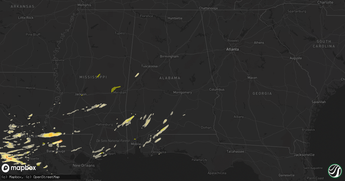
Hail Map in Alabama on February 15, 2016
Get this storm
February 15 map
$229
one time, instant access
Download today. No call, no setup
Keep the $229
Bought the map and want the full workflow? Apply the entire $229 to a subscription within 7 days. None of it is wasted.
Every map, not just this one
This buys you this map. Subscription and you get every map we run, in the markets you choose from a few cities to whole states to nationwide. Plus real-time alerts the moment a storm fires.
Contact data
Name, contact info, occupancy, even credit band for addresses in the footprint. You go from where it hit to who to call.
Become the source they trust
Unlimited branding weather history reports on demand. You already have the documented answer ready for the property owner, and you are the one who showed up with it.
Property data and RoofTrace estimates
Pull up any address you have got, its value and the exact code rules for that jurisdiction, straight from One Click Code. Then RoofTrace estimates the squares, pitch, and roof value, priced the way you price.
Storm reports in Alabama
Alabama
| Date | Description |
|---|---|
| 02/15/20165:59 PM CST | Large trees down near goshen high school. Winds were estimated at 70 to 80 mph. Other than sporadic tree damage the only other damage was to a building at a peanut farm |
| 02/15/20165:57 PM CST | Damaged chicken houses. |
| 02/15/20165:51 PM CST | Barn destroyed on emmett ave. |
| 02/15/20165:49 PM CST | Older barn fell in. |
| 02/15/20165:47 PM CST | Numerous trees down along country drive. One tree fell onto a home causing roof damage. A shed was also destroyed. Winds estimated between 70 to 80 mph. |
| 02/15/20165:46 PM CST | Numerous trees down on straughn school road. Winds estimated between 70 to 80 mph. |
| 02/15/20165:39 PM CST | Tstm wind damage on hwy 97 just south of pettus rd. Deputy sheriff trapped by fallen trees. |
| 02/15/20164:58 PM CST | Winds tore large street lamp out of brick column. Radar observed 53 knot winds. |
| 02/15/20164:57 PM CST | *** 1 inj *** covington county ema reported a mobile home destroyed with 1 injury. |
| 02/15/20164:39 PM CST | Trees down. Powerline poles snapped. |
| 02/15/20164:33 PM CST | Storm chaser reports that a tornado crossed cr-6 and destroyed the johnsonville vfd. A home sustained roof damage with numerous trees and power lines snapped. |
| 02/15/20164:32 PM CST | Trees down along oakley rd. |
| 02/15/20164:28 PM CST | Trees down along oak grove church rd near frisco city and hwy 84. |
| 02/15/20164:26 PM CST | Numerous trees down in the monroeville area. |
| 02/15/20164:24 PM CST | Trees down along south mt pleasant ave between monroeville and hwy 84. |
| 02/15/20164:16 PM CST | Near the intersection of flowers road and matthews road. A few barns damaged... Damage to a tin roof... A few trees down. Possible tornado. Time estimated by radar. |
| 02/15/20164:13 PM CST | Public reports quarter sized hail in saraland. Relayed via social media. |
| 02/15/20164:07 PM CST | Clarke county ema reports a downed tree on gainestown rd in southeastern clarke county. |
| 02/15/20164:05 PM CST | Clarke county ema reports trees down in the thomasville community. |
| 02/15/20164:05 PM CST | Trees down in east brewton. Relayed via social media. |
| 02/15/20164:05 PM CST | Near the intersection of flowers road and matthews road. A few barns damaged... Damage to a tin roof... A few trees down. Tornado. |
| 02/15/20164:05 PM CST | The ending point to the montgomery county tornado... |
| 02/15/20164:05 PM CST | Broadcast media relayed a public report of a tornado along foshee rd near brewton. |
| 02/15/20164:00 PM CST | The tornado first touched down just south of dawson road...topping 2 trees. It then proceeded northeast... Paralleling dawson road. As the tornado approached flowers ro |
| 02/15/20163:55 PM CST | Tree down on a home on conti st in york |
| 02/15/20163:55 PM CST | Clarke county ema reports downed tree on samantha drive in jackson. |
| 02/15/20163:53 PM CST | Clarke county ema reports trees and power lines down on salt works rd. |
| 02/15/20163:51 PM CST | Structural and tree damage reported along fannie rd east of flomaton. Reported by escambia county ema. |
| 02/15/20163:46 PM CST | Clarke county ema reports tree down along mm 13/14 on hwy 69 near old lock one rd. |
| 02/15/20163:41 PM CST | Trees and powerlines down in the pennington community. |
| 02/15/20163:35 PM CST | Trees and powerlines down along cr6 in the silas community. |
| 02/15/20163:33 PM CST | 15-20 trees and powerlines down in the lake lavada subdivision. |
| 02/15/20163:30 PM CST | Trees and powerlines down along bailey road in butler. |
| 02/15/20163:27 PM CST | Powerlines down along frank scrugs rd. |
| 02/15/20163:23 PM CST | Trees and powerlines down in the isney community. |
| 02/15/20163:23 PM CST | Choctaw county reports multiple trees down on melvin cutoff rd. Relayed via social media. |
| 02/15/20163:14 PM CST | Trees down along crawford and cr 1. |
| 02/15/20162:24 PM CST | Quarter size hail reported on social media. |
| 02/15/20162:00 PM CST | Clarke county ema reports trees down near the intersection of walker springs rd and rabbit creek rd |
| 02/15/20161:58 PM CST | Trees down in rose bud along cr 51. |
| 02/15/20161:52 PM CST | Quarter size hail reported on social media. |
| 02/15/20161:15 PM CST | Public report of quarter size hail in yarbo. Relayed via social media. |
| 02/15/20161:05 PM CST | Media relayed public report of quarter size hail in laton hill. |
| 02/15/201612:14 PM CST | Public report of quarter size hail in yarbo. Relayed via social media. |
| 02/15/201612:02 PM CST | Media relayed public report of quarter size hail in laton hill. |
| 02/14/20167:23 PM CST | Fire chief estimates 2 mile section of alabama highway 125 from near mount olive church to tarentum has multiple trees down... Several large trees snapped... Power poles sn ( |
| 02/14/20167:18 PM CST | Multiple trees down around the city of eufaula. 4 chicken houses and nearby residence were also damaged on county road 20. |
| 02/14/20167:15 PM CST | Tree down on the state highway in slocomb |
| 02/14/20167:07 PM CST | Possible roof collapse... Report of kids trapped. Barn damaged. Trees down. Possible tornado. Time estimated by radar. |
| 02/14/20167:06 PM CST | Tree down on brown road near crawford. Time estimated by radar |
| 02/14/20167:05 PM CST | Barn destroyed. Multiple trees down. Power lines down... No power. Possible tornado. Time estimated by radar. |
| 02/14/20167:05 PM CST | Tree down on county road 75. |
| 02/14/20167:03 PM CST | Multiple trees down on green dudley road. Possible tornado. Time estimated by radar. |
| 02/14/20167:00 PM CST | A weak ef0 tornado was confirmed in russell county near the community of crawford. Numerous trees were snapped or uprooted with the heaviest damage noted along brown ro |
| 02/14/20167:00 PM CST | Tree down on car and home. Power lines down. Time estimated by radar. |
| 02/14/20166:57 PM CST | An ef1 tornado was confirmed across northwest russell county near the community of huguley. Numerous trees were uprooted or snapped with the most concentrated damage al |
| 02/14/20166:49 PM CST | Tree down on east county road 19 near intersection with county road 70 |
| 02/14/20166:44 PM CST | Some roofing peeled back on chicken houses. Some minor tree damage at the same location. Time based on radar. |
| 02/14/20166:40 PM CST | Tree down on county road 5 near intersection with county road 245. |
| 02/14/20166:30 PM CST | Multiple trees and power lines down all across coffee county |
| 02/14/20166:23 PM CST | Fire chief estimates 2 mile section of alabama highway 125 from near mount olive church to tarentum has multiple trees down... Several large trees snapped... Power poles sn ( |
| 02/14/20166:20 PM CST | A 5 mile long ef-1 tornado with winds of up to 105 mph touched down just northwest of al hwy 125 approx 1.5 miles west-southwest of us hwy 231. Hundreds of trees were s |
| 02/14/20166:17 PM CST | Trees down on highway 125 between elba and highway 167n |
| 02/14/20166:17 PM CST | Fire chief estimates 2 mile section of alabama highway 125 from near mount olive church to tarentum has multiple trees down... Several large trees snapped... Power poles sn ( |
| 02/14/20166:15 PM CST | Tree down on highway 189 about 5 miles outside of elba along with power lines down |
| 02/14/20166:14 PM CST | Power outages reported in troy. Time estimated by radar. |
| 02/14/20166:10 PM CST | Reports of trees and power lines down in the northwest part of coffee county |
| 02/14/20166:05 PM CST | Trees down near coffee county lake with car damaged from falling trees |
| 02/14/20166:04 PM CST | Large trees down near goshen high school. Time estimated by radar. |
All States Impacted by Hail Map on February 15, 2016
Cities Impacted by Hail Map on February 15, 2016
- Newhebron, MS
- Mendenhall, MS
- Pinola, MS
- Jennings, LA
- Bay Saint Louis, MS
- Kiln, MS
- Erath, LA
- Abbeville, LA
- Woodville, MS
- Saint Francisville, LA
- Boyce, LA
- Otis, LA
- Elmer, LA
- Iowa, LA
- Lake Charles, LA
- Hineston, LA
- Gainestown, AL
- Frisco City, AL
- Uriah, AL
- Franklin, AL
- Little River, AL
- Whatley, AL
- Loxley, AL
- Evergreen, AL
- Forest Hill, LA
- Oakdale, LA
- Glenmora, LA
- Baton Rouge, LA
- Dequincy, LA
- Jena, LA
- Opelousas, LA
- Ville Platte, LA
- Washington, LA
- Port Barre, LA
- Bunkie, LA
- Fort Lauderdale, FL
- Lake Arthur, LA
- Roanoke, LA
- Bell City, LA
- Kinder, LA
- Welsh, LA
- Denham Springs, LA
- Saint Landry, LA
- Bay Springs, MS
- Iota, LA
- Brewton, AL
- Century, FL
- Flomaton, AL
- Eunice, LA
- Church Point, LA
- Longville, LA
- Deville, LA
- Georgiana, AL
- Greenville, AL
- Mize, MS
- Mount Olive, MS
- Raleigh, MS
- Magee, MS
- Taylorsville, MS
- Arnaudville, LA
- Dry Creek, LA
- Sugartown, LA
- Deridder, LA
- Reeves, LA
- Mittie, LA
- Ragley, LA
- Oberlin, LA
- Beaumont, MS
- Gulf Breeze, FL
- Port Arthur, TX
- Nederland, TX
- Groves, TX
- Slaughter, LA
- Ethel, LA
- Boligee, AL
- Eutaw, AL
- Theriot, LA
- Mamou, LA
- Gloster, MS
- Pitkin, LA
- Clinton, LA
- Zachary, LA
- Bonita Springs, FL
- Naples, FL
- Marksville, LA
- Immokalee, FL
- Neely, MS
- Fruitdale, AL
- Millry, AL
- Frankville, AL
- Vinegar Bend, AL
- Richton, MS
- Chatom, AL
- Deer Park, AL
- State Line, MS
- Leakesville, MS
- Cheneyville, LA
- Norwood, LA
- Centreville, MS
- Angola, LA
- Crowley, LA
- Jeanerette, LA
- Jackson, LA
- Brookhaven, MS
- Wesson, MS
- New Iberia, LA
- Gueydan, LA
- Morse, LA
- Liberty, MS
- Osyka, MS
- Magnolia, MS
- Sunset, LA
- Luverne, AL
- Brantley, AL
- Kaplan, LA
- Jackson, AL
- Grove Hill, AL
- Port Neches, TX
- Hackberry, LA
- Beaumont, TX
- Cameron, LA
- Alexandria, LA
- Union Church, MS
- Trout, LA
- Pride, LA
- Cottonport, LA
- Sulphur, LA
- Jay, FL
- Molino, FL
- Loreauville, LA
- Saint Martinville, LA
- Colfax, LA
- Monterey, LA
- Batchelor, LA
- Simmesport, LA
- Lettsworth, LA
- Wilson, LA
- Walker, LA
- Greenwell Springs, LA
- Honoraville, AL
- Fort Deposit, AL
- Letohatchee, AL
- Sieper, LA
- Lena, LA
- Leesville, LA
- Rayne, LA
- Baker, LA
- Mermentau, LA
- Elton, LA
- Egan, LA
- Branch, LA
- Basile, LA
- Pass Christian, MS
- Canton, TX
- Grand Saline, TX
- Franklin, LA
- Woodworth, LA
- Waynesboro, MS
- McDavid, FL
- Krotz Springs, LA
- Melville, LA
- Jonesville, LA
- Repton, AL
- Daphne, AL
- Vancleave, MS
- Lecompte, LA
- Hazlehurst, MS
- Mansura, LA
- Castleberry, AL
- Cloutierville, LA
- Elizabeth, LA
- Crosby, MS
- Stapleton, AL
- Bay Minette, AL
- Slidell, LA
- Diamondhead, MS
- Pearlington, MS
- Loranger, LA
- Hammond, LA
- Ponchatoula, LA
- Robert, LA
- Springfield, LA
- Folsom, LA
- Covington, LA
- Fordoche, LA
- Morganza, LA
- Erwinville, LA
- Lakeland, LA
- Ventress, LA
- Jarreau, LA
- Glynn, LA
- Rougon, LA
- McLain, MS
- Wauchula, FL
- Montgomery, LA
- Natchez, LA
- Picayune, MS
- Stennis Space Center, MS
- Pearl River, LA
- Patterson, LA
- Saint Joseph, LA
- Newellton, LA
- Braxton, MS
- Effie, LA
- Port Allen, LA
- Biloxi, MS
- Gulfport, MS
- Saucier, MS
- Duson, LA
- Port Gibson, MS
- Mccomb, MS
- Tylertown, MS
- New Roads, LA
- Kosciusko, MS
- Carthage, MS
- Pearl, MS
- Flowood, MS
- Chunky, MS
- Bailey, MS
- Decatur, MS
- Meridian, MS
- Little Rock, MS
- Hickory, MS
- Collinsville, MS
- Daleville, MS
- Saraland, AL


