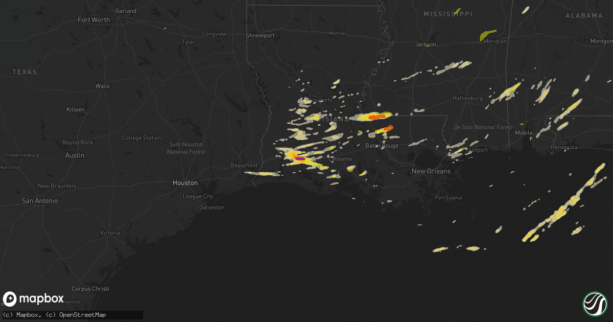
Hail Map on February 15, 2016
Get this storm
February 15 map
$229
one time, instant access
Download today. No call, no setup
Keep the $229
Bought the map and want the full workflow? Apply the entire $229 to a subscription within 7 days. None of it is wasted.
Every map, not just this one
This buys you this map. Subscription and you get every map we run, in the markets you choose from a few cities to whole states to nationwide. Plus real-time alerts the moment a storm fires.
Contact data
Name, contact info, occupancy, even credit band for addresses in the footprint. You go from where it hit to who to call.
Become the source they trust
Unlimited branding weather history reports on demand. You already have the documented answer ready for the property owner, and you are the one who showed up with it.
Property data and RoofTrace estimates
Pull up any address you have got, its value and the exact code rules for that jurisdiction, straight from One Click Code. Then RoofTrace estimates the squares, pitch, and roof value, priced the way you price.
States Impacted by Hail Map on February 15, 2016
Storm reports
Mississippi
| Date | Description |
|---|---|
| 02/15/20163:53 PM CST | Roof blown off an old shed near rocky creek on turkey fork rd. |
| 02/15/20163:25 PM CST | Numerous trees downed around clarke county including several in quitman...where two cars were damaged by falling trees. |
| 02/15/20163:25 PM CST | Tree down on a mobile home. |
| 02/15/20163:20 PM CST | Power lines down at hwy 145 and tm jones rd. |
| 02/15/20163:20 PM CST | Trees downed in the enterprise area. A large tree was blocking an exit ramp along i-59. |
| 02/15/20163:16 PM CST | Trees down across palmer hollinghead and denham progress roads. |
| 02/15/20163:13 PM CST | Tree fell on a house and went through the roof on taylor circle. |
| 02/15/20163:12 PM CST | Large tree on a house. |
| 02/15/20163:12 PM CST | 3 large trees down on old hwy 45 and winchester rd. |
| 02/15/20163:11 PM CST | Mulitple trees down on chicora river road. |
| 02/15/20163:08 PM CST | Powerlines down on ceamon pittman road. |
| 02/15/20163:04 PM CST | 2 large trees reported down near neely rd and hwy 63. |
| 02/15/20163:00 PM CST | A large limb fell onto a home causing minor damage |
| 02/15/20162:54 PM CST | Tin was blown off and scattered through a field along with numerous large limbs and some trees blown down in far southern newton county. |
| 02/15/20162:52 PM CST | Multiple trees and large limbs downed along ms hwy 504 in far northern jasper county. |
| 02/15/20162:50 PM CST | Scattered trees down across the county |
| 02/15/20162:50 PM CST | A roof was damaged along ms highway 503 |
| 02/15/20162:46 PM CST | Several trees down in richton. |
| 02/15/20162:45 PM CST | A large pine tree was downed along ms highway 15 |
| 02/15/20162:40 PM CST | Tree downed at frosty hinton rd and josh hinton rd near soso |
| 02/15/20162:39 PM CST | Large limb caused minor roof damage to a home on bobby beasley st |
| 02/15/20162:36 PM CST | Tree in roadway on lower myrick rd. |
| 02/15/20162:36 PM CST | Tree down across highway 15 south near perry county line. |
| 02/15/20162:35 PM CST | Tree and power lines downed on ramsey mcqueen rd |
| 02/15/20162:33 PM CST | Limb and powerline down on house on north 5th ave... Resulting in a possible fire. |
| 02/15/20162:32 PM CST | Carport was blown over on garden road southwest of laurel. |
| 02/15/20162:28 PM CST | Trees and large limbs were downed in the center ridge area |
| 02/15/20162:20 PM CST | Trees down on chocktaw road. |
| 02/15/20162:20 PM CST | Small tree blocking bonhomie rd |
| 02/15/20162:20 PM CST | Trees downed on houses on elizabeth ave and dixie ave |
| 02/15/20162:15 PM CST | Trees down on jones lane. |
| 02/15/20162:15 PM CST | A few trees and limbs down just inside newton co from jasper co. |
| 02/15/20162:15 PM CST | Trees down on smith lane. |
| 02/15/20162:10 PM CST | Trees down on clem school road. |
| 02/15/20162:10 PM CST | Trees down on keys road. |
| 02/15/20162:10 PM CST | Tree downed on je johnson ave |
| 02/15/20162:10 PM CST | Trees down on roberts road. |
| 02/15/20162:08 PM CST | Emergency manager reports mobile home destroyed with minor injuries on jackson liberty road |
| 02/15/20162:08 PM CST | Emergency manager reports several trees blocking road near colin |
| 02/15/20162:05 PM CST | Quarter size hail reported in diamondhead. Time estimated from radar. |
| 02/15/20162:05 PM CST | Trees down on whitesands road. |
| 02/15/20162:05 PM CST | Trees down on will barber road. |
| 02/15/20162:02 PM CST | Tree downed on sonat rd |
| 02/15/20161:59 PM CST | Trees downed on a home and mobile home in montrose. Multiple trees snapped and uprooted across the area. Reports and pictures relayed via social media. |
| 02/15/20161:58 PM CST | Trees and power lines downed in the louin and montrose areas along cr 20 and ms hwy 15 |
| 02/15/20161:52 PM CST | This tornado began in eastern smith county just west of cr-107 and continued into jasper county...causing significant damage to trees along the path. The tornado contin |
| 02/15/20161:46 PM CST | Structural damage and power lines downed on hwy 18 |
| 02/15/20161:45 PM CST | Major damage to homes and structures in the sylvarena area. Gas pump blown away from james grocery off of highway 18. Reports and pictures relayed via social media. |
| 02/15/20161:43 PM CST | This tornado touched down on cr-84 snapping and uprooting trees...causing damage to homes in the area. The tornado tracked through downtown sylvarena...causing signific |
| 02/15/20161:35 PM CST | Roof damage and damage to shed near intersection of fenn rd and miller rd. Time estimated by radar. |
| 02/15/20161:30 PM CST | A tree fell on a home on fulton st |
| 02/15/20161:30 PM CST | Emergency manager reports several trees blocking road near colin |
| 02/15/20161:30 PM CST | Trees down on e lexie road. House damaged at 69 ginntown rd. Possible tornado. Time estimated by radar. |
| 02/15/20161:24 PM CST | This brief tornado touched down on cr-114 in western smith county before crossing georgia pacific land and ending back on cr-114. A few trees were downed along the path |
| 02/15/20161:20 PM CST | 5-6 homes had minor damage. 3-4 sheds were also destroyed. Both occurred on red star road. Trees were also snapped and uprooted onto powerlines in this area. |
| 02/15/20161:19 PM CST | Emergency manager reports mobile home destroyed with minor injuries on jackson liberty road |
| 02/15/20161:18 PM CST | *** 2 inj *** an intense microburst occurred along the lincoln/copiah co line. Damage occured just w of jackson-liberty rd and n of norton-assink rd. Here a mobile home |
| 02/15/20161:15 PM CST | *** 2 inj *** dozens of trees uprooted or snapped and numerous power lines down. One home had total loss of roof and one exterior wall collapsed. Minor damage to other |
| 02/15/20161:13 PM CST | Trees downed off of hwy 15. |
| 02/15/201612:52 PM CST | Several trees downed along a path between rockport...pinola...and south of mendenhall |
| 02/15/201612:50 PM CST | Trees and powerlines downed in walnut grove. |
| 02/15/201612:47 PM CST | Several trees and several power poles downed along hinze-rural hill rd. |
| 02/15/201612:47 PM CST | Tree down across hinze road. |
| 02/15/201612:47 PM CST | Tree down across hinze road. |
| 02/15/201612:45 PM CST | Several trees snapped or uprooted along hinze road. Tornado rated ef1 with max winds of 105mph. Path length of 2.5 miles and width of 200 yards. |
| 02/15/201612:40 PM CST | Tree downed at 1060 highway 13n. |
| 02/15/201612:34 PM CST | Trees down in the area and on a house at 687 lower rockport road. |
| 02/15/201612:33 PM CST | A tree fell on a semi truck along ms hwy 27...briefly trapping a person |
| 02/15/201612:23 PM CST | Home damaged in the stronghope community. |
| 02/15/201612:19 PM CST | Nws storm survey rated an ef2 tornado with max winds of 130mph. Highest damage found in stronghope where house was obliterated. Survey is still ongoing. |
| 02/15/201612:18 PM CST | Trees downed and chicken houses destroyed at cooper rd and waggoner rd near the conway community. Home had roof damage and a shed was destroyed here also. |
| 02/15/201612:15 PM CST | The roof of a shop building was damaged |
| 02/15/201612:15 PM CST | Numerous trees downed along ms hwy 429 |
| 02/15/201612:15 PM CST | Numerous trees downed along ms hwy 429. Three chicken houses flattened and one damaged. Heavy tree damage evident along path. 1.9 mile path length. 300 yards wide. 110 |
| 02/15/201612:15 PM CST | Tree downed at 244 melissa drive. |
| 02/15/201612:12 PM CST | Trees down on hwy 51 north of barner rd. |
| 02/15/201612:12 PM CST | Roof damage to wesson attendance center. |
| 02/15/201612:10 PM CST | Damage began in wesson and occurred to wesson attendance center. Numerous trees were snapped and uprooted along the path. Highest rated damage of ef2 occurred in strong |
| 02/15/201611:55 AM CST | Several reportes of quarter size hail. Relayed via social media. |
| 02/15/201611:53 AM CST | Quarter sized hail reported in centreville. Time estimated by radar. |
| 02/15/201611:42 AM CST | Two trees down off whitaker rd. Less than one mile north of state line. |
| 02/15/201611:37 AM CST | Tree down on cupit road. |
| 02/15/201611:23 AM CST | Quarter sized hail reported near pleasant hill rd and hwy 63. |
| 02/15/201611:15 AM CST | Tree downed across old agency rd near mockingbird ln |
| 02/15/201611:10 AM CST | Tree down on norton rd. |
| 02/15/201611:10 AM CST | Mobile home destroyed on norton road. 5 homes had minor damage. Trees were snapped and twisted. |
| 02/15/201611:08 AM CST | Trees downed along cynthia rd |
| 02/15/201611:05 AM CST | Tree down on oakley rd near learned. |
| 02/15/201611:05 AM CST | Tree down on stampley road. |
| 02/15/201611:00 AM CST | This weak and brief tornado touched down in the southern oaks subdivision just off pinehaven dr. A few cedar trees were snapped and the top of one hardwood tree was blo |
| 02/15/201610:55 AM CST | Tree down on learned road and also on old port gibson road. |
| 02/15/201610:35 AM CST | Tree down on old port gibson rd. |
| 02/15/201610:15 AM CST | Powerline and tree down on chapman ranch rd. |
| 02/15/201610:05 AM CST | Occurred near center ridge |
| 02/15/20169:55 AM CST | Picture received via twitter |
| 02/15/20169:33 AM CST | Nickel to quarter size hail |
Alabama
| Date | Description |
|---|---|
| 02/15/20165:59 PM CST | Large trees down near goshen high school. Winds were estimated at 70 to 80 mph. Other than sporadic tree damage the only other damage was to a building at a peanut farm |
| 02/15/20165:57 PM CST | Damaged chicken houses. |
| 02/15/20165:51 PM CST | Barn destroyed on emmett ave. |
| 02/15/20165:49 PM CST | Older barn fell in. |
| 02/15/20165:47 PM CST | Numerous trees down along country drive. One tree fell onto a home causing roof damage. A shed was also destroyed. Winds estimated between 70 to 80 mph. |
| 02/15/20165:46 PM CST | Numerous trees down on straughn school road. Winds estimated between 70 to 80 mph. |
| 02/15/20165:39 PM CST | Tstm wind damage on hwy 97 just south of pettus rd. Deputy sheriff trapped by fallen trees. |
| 02/15/20164:58 PM CST | Winds tore large street lamp out of brick column. Radar observed 53 knot winds. |
| 02/15/20164:57 PM CST | *** 1 inj *** covington county ema reported a mobile home destroyed with 1 injury. |
| 02/15/20164:39 PM CST | Trees down. Powerline poles snapped. |
| 02/15/20164:33 PM CST | Storm chaser reports that a tornado crossed cr-6 and destroyed the johnsonville vfd. A home sustained roof damage with numerous trees and power lines snapped. |
| 02/15/20164:32 PM CST | Trees down along oakley rd. |
| 02/15/20164:28 PM CST | Trees down along oak grove church rd near frisco city and hwy 84. |
| 02/15/20164:26 PM CST | Numerous trees down in the monroeville area. |
| 02/15/20164:24 PM CST | Trees down along south mt pleasant ave between monroeville and hwy 84. |
| 02/15/20164:16 PM CST | Near the intersection of flowers road and matthews road. A few barns damaged... Damage to a tin roof... A few trees down. Possible tornado. Time estimated by radar. |
| 02/15/20164:13 PM CST | Public reports quarter sized hail in saraland. Relayed via social media. |
| 02/15/20164:07 PM CST | Clarke county ema reports a downed tree on gainestown rd in southeastern clarke county. |
| 02/15/20164:05 PM CST | Trees down in east brewton. Relayed via social media. |
| 02/15/20164:05 PM CST | Clarke county ema reports trees down in the thomasville community. |
| 02/15/20164:05 PM CST | The ending point to the montgomery county tornado... |
| 02/15/20164:05 PM CST | Near the intersection of flowers road and matthews road. A few barns damaged... Damage to a tin roof... A few trees down. Tornado. |
| 02/15/20164:05 PM CST | Broadcast media relayed a public report of a tornado along foshee rd near brewton. |
| 02/15/20164:00 PM CST | The tornado first touched down just south of dawson road...topping 2 trees. It then proceeded northeast... Paralleling dawson road. As the tornado approached flowers ro |
| 02/15/20163:55 PM CST | Clarke county ema reports downed tree on samantha drive in jackson. |
| 02/15/20163:55 PM CST | Tree down on a home on conti st in york |
| 02/15/20163:53 PM CST | Clarke county ema reports trees and power lines down on salt works rd. |
| 02/15/20163:51 PM CST | Structural and tree damage reported along fannie rd east of flomaton. Reported by escambia county ema. |
| 02/15/20163:46 PM CST | Clarke county ema reports tree down along mm 13/14 on hwy 69 near old lock one rd. |
| 02/15/20163:41 PM CST | Trees and powerlines down in the pennington community. |
| 02/15/20163:35 PM CST | Trees and powerlines down along cr6 in the silas community. |
| 02/15/20163:33 PM CST | 15-20 trees and powerlines down in the lake lavada subdivision. |
| 02/15/20163:30 PM CST | Trees and powerlines down along bailey road in butler. |
| 02/15/20163:27 PM CST | Powerlines down along frank scrugs rd. |
| 02/15/20163:23 PM CST | Choctaw county reports multiple trees down on melvin cutoff rd. Relayed via social media. |
| 02/15/20163:23 PM CST | Trees and powerlines down in the isney community. |
| 02/15/20163:14 PM CST | Trees down along crawford and cr 1. |
| 02/15/20162:24 PM CST | Quarter size hail reported on social media. |
| 02/15/20162:00 PM CST | Clarke county ema reports trees down near the intersection of walker springs rd and rabbit creek rd |
| 02/15/20161:58 PM CST | Trees down in rose bud along cr 51. |
| 02/15/20161:52 PM CST | Quarter size hail reported on social media. |
| 02/15/20161:15 PM CST | Public report of quarter size hail in yarbo. Relayed via social media. |
| 02/15/20161:05 PM CST | Media relayed public report of quarter size hail in laton hill. |
| 02/15/201612:14 PM CST | Public report of quarter size hail in yarbo. Relayed via social media. |
| 02/15/201612:02 PM CST | Media relayed public report of quarter size hail in laton hill. |
| 02/14/20167:23 PM CST | Fire chief estimates 2 mile section of alabama highway 125 from near mount olive church to tarentum has multiple trees down... Several large trees snapped... Power poles sn ( |
| 02/14/20167:18 PM CST | Multiple trees down around the city of eufaula. 4 chicken houses and nearby residence were also damaged on county road 20. |
| 02/14/20167:15 PM CST | Tree down on the state highway in slocomb |
| 02/14/20167:07 PM CST | Possible roof collapse... Report of kids trapped. Barn damaged. Trees down. Possible tornado. Time estimated by radar. |
| 02/14/20167:06 PM CST | Tree down on brown road near crawford. Time estimated by radar |
| 02/14/20167:05 PM CST | Barn destroyed. Multiple trees down. Power lines down... No power. Possible tornado. Time estimated by radar. |
| 02/14/20167:05 PM CST | Tree down on county road 75. |
| 02/14/20167:03 PM CST | Multiple trees down on green dudley road. Possible tornado. Time estimated by radar. |
| 02/14/20167:00 PM CST | A weak ef0 tornado was confirmed in russell county near the community of crawford. Numerous trees were snapped or uprooted with the heaviest damage noted along brown ro |
| 02/14/20167:00 PM CST | Tree down on car and home. Power lines down. Time estimated by radar. |
| 02/14/20166:57 PM CST | An ef1 tornado was confirmed across northwest russell county near the community of huguley. Numerous trees were uprooted or snapped with the most concentrated damage al |
| 02/14/20166:49 PM CST | Tree down on east county road 19 near intersection with county road 70 |
| 02/14/20166:44 PM CST | Some roofing peeled back on chicken houses. Some minor tree damage at the same location. Time based on radar. |
| 02/14/20166:40 PM CST | Tree down on county road 5 near intersection with county road 245. |
| 02/14/20166:30 PM CST | Multiple trees and power lines down all across coffee county |
| 02/14/20166:23 PM CST | Fire chief estimates 2 mile section of alabama highway 125 from near mount olive church to tarentum has multiple trees down... Several large trees snapped... Power poles sn ( |
| 02/14/20166:20 PM CST | A 5 mile long ef-1 tornado with winds of up to 105 mph touched down just northwest of al hwy 125 approx 1.5 miles west-southwest of us hwy 231. Hundreds of trees were s |
| 02/14/20166:17 PM CST | Fire chief estimates 2 mile section of alabama highway 125 from near mount olive church to tarentum has multiple trees down... Several large trees snapped... Power poles sn ( |
| 02/14/20166:17 PM CST | Trees down on highway 125 between elba and highway 167n |
| 02/14/20166:15 PM CST | Tree down on highway 189 about 5 miles outside of elba along with power lines down |
| 02/14/20166:14 PM CST | Power outages reported in troy. Time estimated by radar. |
| 02/14/20166:10 PM CST | Reports of trees and power lines down in the northwest part of coffee county |
| 02/14/20166:05 PM CST | Trees down near coffee county lake with car damaged from falling trees |
| 02/14/20166:04 PM CST | Large trees down near goshen high school. Time estimated by radar. |
Louisiana
| Date | Description |
|---|---|
| 02/15/20163:48 PM CST | Public posted photo of quarter size hail to social media. |
| 02/15/20163:47 PM CST | Public measured 1 inch hail in new iberia |
| 02/15/20163:00 PM CST | Roof blown off of trailer. |
| 02/15/20162:35 PM CST | Quarter sized hail reported in milldale. |
| 02/15/20162:17 PM CST | Public posted photo of 2 inch hail near welsh to social media. |
| 02/15/20162:06 PM CST | Public posted photo of 2 inch hail to social media. Time estimated from radar. |
| 02/15/20161:45 PM CST | Public measured 2 inch hail in iowa. |
| 02/15/20161:35 PM CST | Media relayed report of quarter size hail |
| 02/15/20161:25 PM CST | A local report indicates 1.00 inch wind near MOSS BLUFF |
| 02/15/20161:16 PM CST | Public posted photo of quarter size hail to social media. Time estimated from radar. |
| 02/15/20161:04 PM CST | A tornado touched down near arceneaux road and moved to the northeast through open fields before lifting. No damage was reported. |
| 02/15/20161:00 PM CST | Public posted photo of quarter size hail to social media. |
| 02/15/201612:50 PM CST | Golf ball sized hail reported in slaughter. Relayed via social media. Time estimated based on radar. |
| 02/15/201612:45 PM CST | Public posted photo of quarter size hail to social media. |
| 02/15/201612:20 PM CST | Damage reported to two buisinesses in alexandria. Media photos indicate a portion of the roof of a pizza hut was blown off and a wall of a car wash was blown down. |
| 02/15/201612:15 PM CST | Ham operator relayed a report of 1 inch hail and estimated winds of 50 mph. |
| 02/15/201611:38 AM CST | Few trees down. |
| 02/15/201611:38 AM CST | Ping pong ball sized hail reported at south of the border gas station. |
| 02/15/201611:28 AM CST | Few trees down. |
| 02/15/201611:00 AM CST | Strong winds blew down an aluminum structure for solar panels |
| 02/15/201610:22 AM CST | Nws storm survey confirms a weak ef0 tornado briefly touched down on hwy 1181 ese of plaucheville. |
| 02/15/201610:20 AM CST | Plaucheville city hall reports damage to house on hwy 1181. |
| 02/15/20169:30 AM CST | Broadcast media relayed report of portion of a roof being pulled off a house |
Florida
| Date | Description |
|---|---|
| 02/15/20165:53 PM CST | Tree blown down on a car. Relayed via social media. |
| 02/15/20165:53 PM CST | 18-wheeler slammed against a tree in a walmart parking lot. Wind damage to stores at a neighboring strip mall. Relayed via social media. |
| 02/15/20165:50 PM CST | Tree blown down on a car near nine mile and guidy. Relayed via social media. |
| 02/15/20165:50 PM CST | Damage to an awning at a truck stop. Relayed via social media. |
| 02/15/20165:46 PM CST | Tree blown down on a truck at timberlake mobile home park. Reported relayed via social media. |
| 02/15/20164:54 PM CST | Quarter size hail reported in new york... Fl. Relayed via social media. |
| 02/15/20163:33 PM CST | Broadcast media reports multiple homes damaged or destroyed from mcdavid to century. Radar observed tornado debris signature. |
| 02/15/20165:53 AM CST | Large branches down around roosevelt elementary school. Radar estimated winds in the area of 60 to 70 mph. |
| 02/15/20164:15 AM CST | Mesonet site l006 on lake okeechobee recorded a wind gust to 56 knots 64 mph from the southeast |
| 02/15/20164:10 AM CST | Fhp officer headed eastbound on i-75 reported a tornado touchdown north of the highway around mile marker 70 at 510am. The officer lost site of the tornado at mile mark |
| 02/15/20164:10 AM CST | Fhp officer headed eastbound on i-75 reported a tornado touchdown north of the highway around mile marker 70 at 510am. The officer lost site of the tornado at mile mark |
| 02/15/20163:50 AM CST | Wind gusts from a thunderstorm caused damage to a trailer and its tent twisted on top. Roof damage to a house along western ave was reported as well as trees and powerl |
| 02/15/20163:49 AM CST | Several mobile homes significantly damaged. Damage to a trailer and its tent twisted on top. Roof damage to a house along western ave was reported as well as trees and |
| 02/15/20163:14 AM CST | Several mobile home carports damaged along amethyst avenue in the enchanting shores co-op park. An additional mobile home in the neighborhood suffered damage to its roo |
| 02/14/201610:25 PM CST | Trees were blown down on w w kelly road during the monday night storms. |
| 02/14/201610:25 PM CST | Trees were blown down on natural bridge road near old plank road during the monday night storms. |
| 02/14/201610:15 PM CST | Multiple trees down |
| 02/14/201610:02 PM CST | Peak gust of 81 mph measured at fsu coastal and marine lab weatherstem site on the franklin county coast. Also some tree damage...light debris scattered such as metal s |
| 02/14/20169:55 PM CST | Multiple trees blown down in the sopchoppy area and also near the coastal highway. |
| 02/14/20169:46 PM CST | Trees down and damage to a shed in lanark village. |
| 02/14/20169:41 PM CST | Tree on residence. |
| 02/14/20169:13 PM CST | Multiple trees down. |
| 02/14/20169:07 PM CST | Sr-65 blocked with tree across the road. |
| 02/14/20168:00 PM CST | Roof blown off house. Numerous trees and power lines down across city. |
| 02/14/20168:00 PM CST | Possible tornado touchdown but no damage except for trees down in a field. |
| 02/14/20167:55 PM CST | Several reports of trees and power lines down throughout jackson county |
| 02/14/20167:47 PM CST | Trees snapped near corbin road and highway 231. Public report to wjhg-tv facebook page. |
| 02/14/20167:36 PM CST | Numerous reports of trees and power lines down throughout washington county |
| 02/14/20167:33 PM CST | Tree down on the corner of a carport on the north side of chipley. Other reports of tree damage in chipley. Public reports to wmbb-tv facebook page. |
| 02/14/20167:22 PM CST | Tree down just south of bonifay |
| 02/14/20167:22 PM CST | High tension power line down on highway 98 near breakers street resulting in a large power outage |
| 02/14/20167:08 PM CST | Tree down in ponce de leon |
| 02/14/20166:57 PM CST | Trees down in topsill state park |
| 02/14/20166:50 PM CST | Trees down on otter pond road near highway 2 |
| 02/14/20166:50 PM CST | Tree down on county road 185 near bartlett road |
| 02/14/20166:33 PM CST | The valparaiso kvps asos measured a wind gust of 60 mph. |
| 02/14/20166:26 PM CST | Straight line wind damage on woodbridge rd in niceville. Two large trees down and one tree fell on a truck. |
| 02/14/20166:15 PM CST | Minor roof damage to residences at james harvell rd and hwy 87. |
| 02/14/20166:15 PM CST | Moderate roof damage to residences on cosica blvd. |
| 02/14/20166:10 PM CST | Several houses with roof damage in the santa rosa shores area. Large boat picked up and dropped on a pickup truck. Relayed via social media. |
| 02/14/20166:05 PM CST | Broken windows at residences along sea breeze lane. Minor roof damage to multiple homes. Fencing blown down. |
| 02/14/20166:02 PM CST | Pensacola asos measured a wind gust of 60 mph. |
Georgia
| Date | Description |
|---|---|
| 02/15/20161:30 AM CST | Local savannah media relayed a report from savannah police of a tree down on truman parkway near president street. |
| 02/15/20161:25 AM CST | Local savannah media relayed a picture of a tree that fell and brought down power lines near the intersection of i-16 and chatham parkway at savannah christian preparat |
| 02/15/20161:24 AM CST | 3 trees were blown down by thunderstorm winds. One tree blocked balboa blvd. Other fallen trees destroyed a storage building...damaged wooden and chain link fences and |
| 02/15/201612:57 AM CST | Fort stewart emergency management reported a small guard/fuel shack was blown off its foundation and torn apart. Time estimated from radar. |
| 02/15/201612:51 AM CST | Liberty county emergency management reported a portion of a wooden fence blown over...several large trees uprooted or broken off...and numerous large tree limbs down ar |
| 02/15/201612:45 AM CST | Several trees and power lines down in and near land of lakes mobile home park. Several mobile homes and 4 vehicles also reported with damage. |
| 02/15/201612:34 AM CST | The public reports the walls of a metal shed ripped off...minor vinyl siding damage...a few large trees blown down...and minor shingle damage to a mobile home on sims b |
| 02/15/201612:25 AM CST | The emergency manager conducted a survey and determined that a downburst impacted the area near 3165 old river road. A barn was damaged...the eves of the home were blow |
| 02/15/201612:25 AM CST | Emergency manager determined a downburst impacted the northwest part of the county and caused tree damage and some structural damage near 400 woods farm road where a ba |
| 02/15/201612:20 AM CST | The emergency manager concluded that a downburst impacted the area near 1053 melvin westbury road. Several trees were blown down and a barn was damaged. |
| 02/15/201612:20 AM CST | The emergency manager conducted a storm survey and determined that a downburst impacted the area near 11011 highway 169 where numerous trees were blown down...approxima |
| 02/15/201612:06 AM CST | There were reports of trees down and damage to homes along metts overstreet rd in the southern portion of the county. The time given was based on radar. |
| 02/14/201611:54 PM CST | There were reports of trees down and damage to homes. The time given was based on radar. |
| 02/14/201611:54 PM CST | A large tree fell and damaged a semi near the bacon and pierce border. The time listed was based on radar. |
| 02/14/201611:25 PM CST | Widespread trees were blown down in pearson. A large tree was blown down onto powerlines. The time of damage was based on radar imagery. |
| 02/14/20168:25 PM CST | Estimated peak wind around 80 mph. The damage occured along rock hill school road where 30 to 50 medium to large pine trees were uprooted. The trees were all laying in |
| 02/14/20168:20 PM CST | A tree and powerlines were blown down onto lanier rd. |
| 02/14/20168:15 PM CST | Trees down in the graves area |
| 02/14/20168:10 PM CST | A large cedar tree was blown down at highway 74 and lawrence rd. |
| 02/14/20168:10 PM CST | A large tree was blown onto pleasant valley rd at lawrence road. |
| 02/14/20168:07 PM CST | Trees down in the shellman area |
| 02/14/20167:57 PM CST | Trees down on highway 216 |
| 02/14/20167:40 PM CST | A tree was blown down onto miller rd. Crews are working to clear the road. |
| 02/14/20167:30 PM CST | Two trees down on hwy 39 about 1 mile southwest of omaha. |
| 02/14/20167:20 PM CST | 2 reports of trees down in quitman county |
North Carolina
| Date | Description |
|---|---|
| 02/15/20165:55 AM CST | Tree down onn route 581. Time estimated by radar. |
| 02/15/20165:55 AM CST | Treee down near sims. Time estiamted by radar. |
| 02/15/20165:55 AM CST | Emergency manager reported several trees down near perrytown including one tree on a vacant mobile home. Time estimated by radar. |
| 02/15/20165:55 AM CST | Emergency manager reported a couple of trees down near warren plains. Time estimated by radar. |
| 02/15/20165:52 AM CST | Trees and power lines down on highway 39 just outside of epsom. |
| 02/15/20165:10 AM CST | Trees and power lines down at avent ferry road and lake dam road. |
| 02/15/20165:05 AM CST | Tree down pulling powerlines to the ground. Time estimated by radar. |
| 02/15/20165:05 AM CST | Tree down on a house on ashley ridge drive. Report from wral. |
| 02/15/20165:04 AM CST | Tree down on alderman circle and fanny brown rd. |
| 02/15/20165:04 AM CST | Tree down on valey run drive in greystone neighborhood. |
Cities Impacted by Hail Map on February 15, 2016
- Newhebron, MS
- Mendenhall, MS
- Pinola, MS
- Jennings, LA
- Bay Saint Louis, MS
- Kiln, MS
- Erath, LA
- Abbeville, LA
- Woodville, MS
- Saint Francisville, LA
- Boyce, LA
- Otis, LA
- Elmer, LA
- Iowa, LA
- Lake Charles, LA
- Hineston, LA
- Gainestown, AL
- Frisco City, AL
- Uriah, AL
- Franklin, AL
- Little River, AL
- Whatley, AL
- Loxley, AL
- Evergreen, AL
- Forest Hill, LA
- Oakdale, LA
- Glenmora, LA
- Baton Rouge, LA
- Dequincy, LA
- Jena, LA
- Opelousas, LA
- Ville Platte, LA
- Washington, LA
- Port Barre, LA
- Bunkie, LA
- Fort Lauderdale, FL
- Lake Arthur, LA
- Roanoke, LA
- Bell City, LA
- Kinder, LA
- Welsh, LA
- Denham Springs, LA
- Saint Landry, LA
- Bay Springs, MS
- Iota, LA
- Brewton, AL
- Century, FL
- Flomaton, AL
- Eunice, LA
- Church Point, LA
- Longville, LA
- Deville, LA
- Georgiana, AL
- Greenville, AL
- Mize, MS
- Mount Olive, MS
- Raleigh, MS
- Magee, MS
- Taylorsville, MS
- Arnaudville, LA
- Dry Creek, LA
- Sugartown, LA
- Deridder, LA
- Reeves, LA
- Mittie, LA
- Ragley, LA
- Oberlin, LA
- Beaumont, MS
- Gulf Breeze, FL
- Port Arthur, TX
- Nederland, TX
- Groves, TX
- Slaughter, LA
- Ethel, LA
- Boligee, AL
- Eutaw, AL
- Theriot, LA
- Mamou, LA
- Gloster, MS
- Pitkin, LA
- Clinton, LA
- Zachary, LA
- Bonita Springs, FL
- Naples, FL
- Marksville, LA
- Immokalee, FL
- Neely, MS
- Fruitdale, AL
- Millry, AL
- Frankville, AL
- Vinegar Bend, AL
- Richton, MS
- Chatom, AL
- Deer Park, AL
- State Line, MS
- Leakesville, MS
- Cheneyville, LA
- Norwood, LA
- Centreville, MS
- Angola, LA
- Crowley, LA
- Jeanerette, LA
- Jackson, LA
- Brookhaven, MS
- Wesson, MS
- New Iberia, LA
- Gueydan, LA
- Morse, LA
- Liberty, MS
- Osyka, MS
- Magnolia, MS
- Sunset, LA
- Luverne, AL
- Brantley, AL
- Kaplan, LA
- Jackson, AL
- Grove Hill, AL
- Port Neches, TX
- Hackberry, LA
- Beaumont, TX
- Cameron, LA
- Alexandria, LA
- Union Church, MS
- Trout, LA
- Pride, LA
- Cottonport, LA
- Sulphur, LA
- Jay, FL
- Molino, FL
- Loreauville, LA
- Saint Martinville, LA
- Colfax, LA
- Monterey, LA
- Batchelor, LA
- Simmesport, LA
- Lettsworth, LA
- Wilson, LA
- Walker, LA
- Greenwell Springs, LA
- Honoraville, AL
- Fort Deposit, AL
- Letohatchee, AL
- Sieper, LA
- Lena, LA
- Leesville, LA
- Rayne, LA
- Baker, LA
- Mermentau, LA
- Elton, LA
- Egan, LA
- Branch, LA
- Basile, LA
- Pass Christian, MS
- Canton, TX
- Grand Saline, TX
- Franklin, LA
- Woodworth, LA
- Waynesboro, MS
- McDavid, FL
- Krotz Springs, LA
- Melville, LA
- Jonesville, LA
- Repton, AL
- Daphne, AL
- Vancleave, MS
- Lecompte, LA
- Hazlehurst, MS
- Mansura, LA
- Castleberry, AL
- Cloutierville, LA
- Elizabeth, LA
- Crosby, MS
- Stapleton, AL
- Bay Minette, AL
- Slidell, LA
- Diamondhead, MS
- Pearlington, MS
- Loranger, LA
- Hammond, LA
- Ponchatoula, LA
- Robert, LA
- Springfield, LA
- Folsom, LA
- Covington, LA
- Fordoche, LA
- Morganza, LA
- Erwinville, LA
- Lakeland, LA
- Ventress, LA
- Jarreau, LA
- Glynn, LA
- Rougon, LA
- McLain, MS
- Wauchula, FL
- Montgomery, LA
- Natchez, LA
- Picayune, MS
- Stennis Space Center, MS
- Pearl River, LA
- Patterson, LA
- Saint Joseph, LA
- Newellton, LA
- Braxton, MS
- Effie, LA
- Port Allen, LA
- Biloxi, MS
- Gulfport, MS
- Saucier, MS
- Duson, LA
- Port Gibson, MS
- Mccomb, MS
- Tylertown, MS
- New Roads, LA
- Kosciusko, MS
- Carthage, MS
- Pearl, MS
- Flowood, MS
- Chunky, MS
- Bailey, MS
- Decatur, MS
- Meridian, MS
- Little Rock, MS
- Hickory, MS
- Collinsville, MS
- Daleville, MS
- Saraland, AL