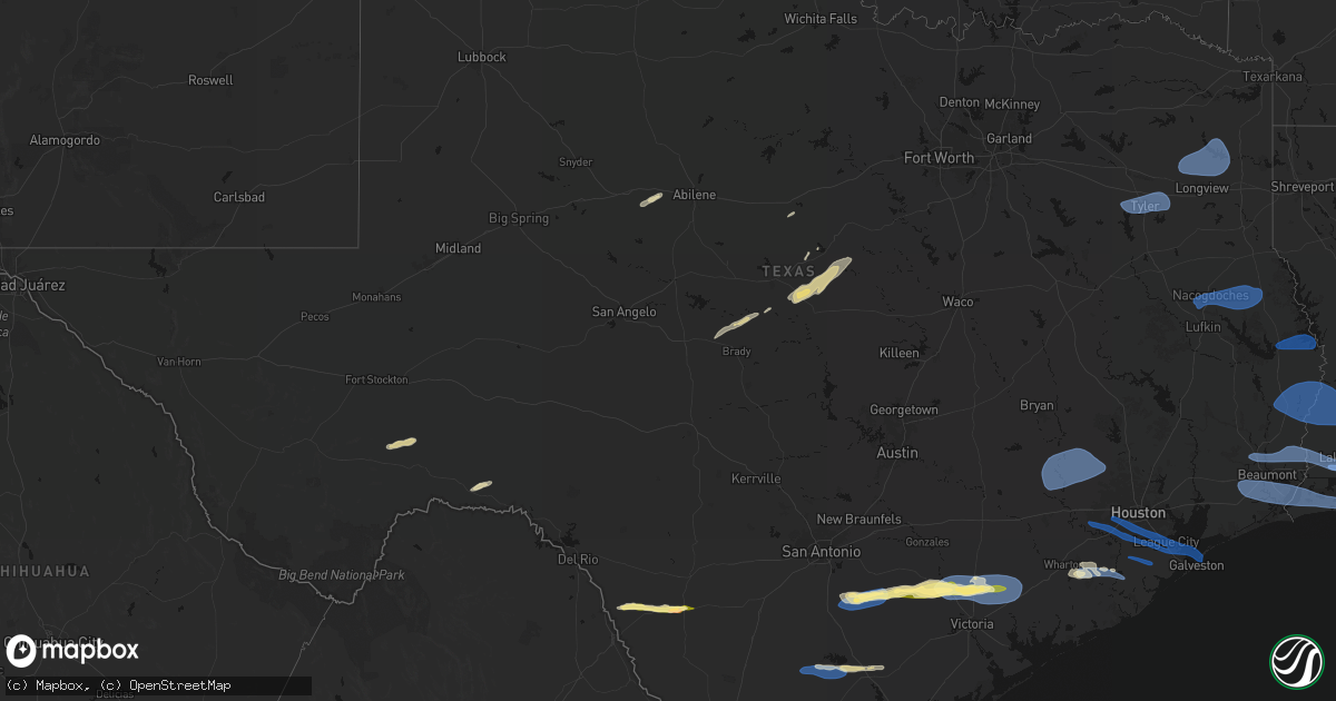
Hail Map in Texas on February 14, 2026
Get this storm
February 14 map
$229
one time, instant access
Download today. No call, no setup
Keep the $229
Bought the map and want the full workflow? Apply the entire $229 to a subscription within 7 days. None of it is wasted.
Every map, not just this one
This buys you this map. Subscription and you get every map we run, in the markets you choose from a few cities to whole states to nationwide. Plus real-time alerts the moment a storm fires.
Contact data
Name, contact info, occupancy, even credit band for addresses in the footprint. You go from where it hit to who to call.
Become the source they trust
Unlimited branding weather history reports on demand. You already have the documented answer ready for the property owner, and you are the one who showed up with it.
Property data and RoofTrace estimates
Pull up any address you have got, its value and the exact code rules for that jurisdiction, straight from One Click Code. Then RoofTrace estimates the squares, pitch, and roof value, priced the way you price.
Storm reports in Texas
Texas
| Date | Description |
|---|---|
| 02/14/20265:59 PM CST | Power lines down and several trees with tin roof wrapped in debris reported in splendora near intersection of morgan dr at morton dr. |
| 02/14/20265:50 PM CST | Law enforcement received report of a downed power line along hwy 7 e at cr 3156. |
| 02/14/20265:19 PM CST | Report from mping: half dollar |
| 02/14/20265:15 PM CST | Law enforcement received numerous reports of wind related damage... Resulting in multiple service runs related to downed power lines across nacogdoches city and county. |
| 02/14/20265:00 PM CST | Mesonet station 124ce 116 ives creek. |
| 02/14/20265:00 PM CST | Media reported 65 mph wind gust in ives creek... Tx. |
| 02/14/20264:53 PM CST | Social media picture featuring hailstones up to penny to quarter size. Time estimated via radar. |
| 02/14/20264:50 PM CST | Quarter sized hail on smith ranch road reported by dewitt county emergency management. |
| 02/14/20264:40 PM CST | Law enforcement received reports of downed trees and power lines along fm 225 between cushing and douglass. |
| 02/14/20264:30 PM CST | Large downed tree branches greater than 6 to 9 inches in diameter. Near the intersection of cabeza road and edmund mueller northwest of nordheim. Time estimated via rad |
| 02/14/20264:14 PM CST | Report of tree down near cr 118 that the local fire department cleared off the road. |
| 02/14/20264:05 PM CST | Mesonet station tw109 three oaks. |
| 02/14/20263:53 PM CST | An mping report of power lines down was submitted north of gladewater... Tx. |
| 02/14/20263:45 PM CST | Law enforcement received a report of a downed power line at the intersection of pyeatt dr and north point pleasant rd. |
| 02/14/20263:41 PM CST | Damage to 2 houses and a boat house on lake gladewater. |
| 02/14/20263:40 PM CST | Law enforcement received a report of a downed tree along farm to market road 757. |
| 02/14/20263:40 PM CST | Law enforcement received a report of a downed tree northeast of big sandy. |
| 02/14/20263:38 PM CST | An mping report of 1-inch tree limbs broken was submitted at 3:38pm south of gilmer... Tx. |
| 02/14/20263:29 PM CST | Measured at tyler pounds field airport asos. |
| 02/14/20262:42 PM CST | Photo and video via social media with the biggest stones around or slightly bigger than a quarter. Time estimated via radar. |
| 02/13/20268:02 PM CST | Photo received of damage to deweyville united pentecostal church. Portion of the outside wooden covering was blown off. |
| 02/13/20267:59 PM CST | Kfdm mesonet. |
| 02/13/20267:48 PM CST | Corrects previous report from 7 wsw high island for report type. Report from noaa ocean service - tides and water levels obs. |
| 02/13/20267:48 PM CST | Report from noaa ocean service - tides and water levels obs. |
| 02/13/20267:38 PM CST | Measured by kfdm mesonet at utophia ranch. |
| 02/13/20267:35 PM CST | Tree limbs on home and carport. Possible tornado. |
| 02/13/20267:27 PM CST | Vfd reports tree on a home and downed powerlines. Exact location not known... Time estimated by radar. |
| 02/13/20267:25 PM CST | Mesonet station xlev levee. |
| 02/13/20267:25 PM CST | Corrects previous non-tstm wnd gst report from 4 ene texas city for proper report type. Mesonet station xlev levee. |
| 02/13/20267:22 PM CST | At kfdm mesonet lumberton middle school. |
| 02/13/20267:02 PM CST | Staircase damaged at a motel in webster at the intersection of nasa parkway and north kobayashi road. |
| 02/13/20267:00 PM CST | Mesonet station 028ce 61 rosharon. |
| 02/13/20267:00 PM CST | Mesonet station 024ce 39 chocolate springs. |
| 02/13/20266:55 PM CST | Downed tree reported at apartment complex near intersection of bay area blvd and glenwest dr. |
| 02/13/20266:51 PM CST | Fences down near blackhawk blvd at lettie ave just north of beltway 8. |
| 02/13/20266:50 PM CST | Mesonet station 141ce 143 rosharon. |
| 02/13/20266:46 PM CST | Damage reported near barbara cockrell elementary in pearland. Fences down and trampolines blown onto structures. |
| 02/13/20266:42 PM CST | Mesonet station fw9607 kingsville. |
| 02/13/20266:40 PM CST | Mesonet station 060ce 17 brazoria solar. |
| 02/13/20266:18 PM CST | Downed tree in the backyard of a residence in sugar land. |
| 02/13/20266:15 PM CST | Fence down and damage to a garage door in sugar mill |
| 02/13/20266:15 PM CST | 67 mph gust reported at sugar land regional airport. |
| 02/13/20266:12 PM CST | Asos station ksgr houston sugar la. |
All States Impacted by Hail Map on February 14, 2026
Cities Impacted by Hail Map on February 14, 2026
- Sweetwater, TX
- Fort Stockton, TX
- Merkel, TX
- Rising Star, TX
- Dryden, TX
- Carbon, TX
- Gorman, TX
- Lohn, TX
- Melvin, TX
- Rochelle, TX
- Comstock, TX
- Brownwood, TX
- Mullin, TX
- Comanche, TX
- Zephyr, TX
- Early, TX
- Priddy, TX
- Gustine, TX
- Hamilton, TX
- Goldthwaite, TX
- Dublin, TX
- Carlton, TX
- Quemado, TX
- Eagle Pass, TX
- Crystal City, TX
- La Pryor, TX
- Batesville, TX
- Chandler, TX
- Gilmer, TX
- Ore City, TX
- Diana, TX
- Longview, TX
- Tyler, TX
- Flint, TX
- Whitehouse, TX
- Arp, TX
- Floresville, TX
- Lone Star, TX
- Avinger, TX
- Jefferson, TX
- Hallsville, TX
- Harleton, TX
- Laredo, TX
- Poth, TX
- Falls City, TX
- Pleasanton, TX
- Hobson, TX
- Karnes City, TX
- Stockdale, TX
- Gillett, TX
- Ecleto, TX
- Yorktown, TX
- Westhoff, TX
- Cuero, TX
- Yoakum, TX
- Childress, TX
- Calliham, TX
- Tilden, TX
- Three Rivers, TX
- George West, TX
- Edna, TX
- Inez, TX
- Magnolia, TX
- Pinehurst, TX
- Hallettsville, TX
- Victoria, TX
- Ganado, TX
- Louise, TX
- Beeville, TX
- Waller, TX
- Hockley, TX
- Hempstead, TX
- Chappell Hill, TX
- Bellville, TX
- Prairie View, TX
- Tomball, TX
- Washington, TX
- Brenham, TX
- Navasota, TX
- Plantersville, TX
- Montgomery, TX
- Concepcion, TX
- Boling, TX
- Pledger, TX
- Sweeny, TX
- Damon, TX
- Guy, TX
- Richmond, TX
- Sugar Land, TX
- Missouri City, TX
- Fresno, TX
- Stafford, TX
- Rosharon, TX
- Houston, TX
- Wharton, TX
- Alice, TX
- West Columbia, TX
- Kingsville, TX
- Pearland, TX
- Manvel, TX
- Alvin, TX
- Angleton, TX
- Brookeland, TX
- Pineland, TX
- Wiergate, TX
- Hemphill, TX
- Needville, TX
- Friendswood, TX
- Webster, TX
- League City, TX
- Seabrook, TX
- Liverpool, TX
- Santa Fe, TX
- Dickinson, TX
- Texas City, TX
- Kemah, TX
- Bishop, TX
- La Marque, TX
- Burkeville, TX
- Kirbyville, TX
- Corpus Christi, TX
- Bacliff, TX
- Call, TX
- Bon Wier, TX
- Port Bolivar, TX
- Lumberton, TX
- Vidor, TX
- Port Aransas, TX
- Kountze, TX
- Merryville, LA
- Newton, TX
- Buna, TX
- Orange, TX
- Beaumont, TX
- Port Arthur, TX
- Nederland, TX
- Groves, TX
- Port Neches, TX
- Leesville, LA
- Bridge City, TX
- Cameron, LA
- Deweyville, TX
- Vinton, LA
- Starks, LA
- Dequincy, LA
- Longville, LA
- Singer, LA
- Deridder, LA
- Ragley, LA
- Sulphur, LA
- Dry Creek, LA
- Kinder, LA
- Reeves, LA
- Winnie, TX
- Westlake, LA
- Lake Charles, LA
- Mittie, LA
- Oberlin, LA
- Glenmora, LA
- Creole, LA
- Bell City, LA
- Lacassine, LA
- Iowa, LA
- Ville Platte, LA
- Saint Landry, LA
- Cheneyville, LA
- Welsh, LA
- Lake Arthur, LA
- Bunkie, LA
- Jennings, LA
- Marksville, LA
- Hessmer, LA
- Alexandria, LA
- Lecompte, LA
- Morrow, LA
- Evergreen, LA
- Pineville, LA
- Cottonport, LA
- Mansura, LA
- Effie, LA
- Gueydan, LA
- Morse, LA
- Mermentau, LA
- Washington, LA
- Plaucheville, LA
- Crowley, LA
- Simmesport, LA
- Moreauville, LA
- Jonesville, LA
- Monterey, LA
- Melville, LA
- Batchelor, LA
- Lettsworth, LA
- Acme, LA
- Angola, LA
- Woodville, MS
- Saint Francisville, LA
- Vidalia, LA
- Krotz Springs, LA
- Palmetto, LA
- Port Barre, LA
- Morganza, LA
- Fordoche, LA
- Lottie, LA
- Deville, LA
- New Roads, LA
- Livonia, LA
- Maringouin, LA
- Estherwood, LA
- Rayne, LA
- Duson, LA
- Scott, LA
- Ventress, LA
- Oscar, LA
- Jarreau, LA
- Gloster, MS
- Jackson, LA
- Port Allen, LA
- Erwinville, LA
- Lakeland, LA
- Centreville, MS
- Rougon, LA
- Norwood, LA
- Glynn, LA
- Crosby, MS
- Zachary, LA
- Ethel, LA
- Slaughter, LA
- Wilson, LA
- Meadville, MS
- Liberty, MS
- Clinton, LA
- Roxie, MS
- Bude, MS
- Greensburg, LA
- Brookhaven, MS
- Sontag, MS
- Monticello, MS
- Silver Creek, MS
- Kentwood, LA
- Mccomb, MS
- Osyka, MS
- Tylertown, MS
- Magnolia, MS
- Summit, MS
- Smithdale, MS
- McCall Creek, MS
- Bogue Chitto, MS
- Amite, LA
- Mount Hermon, LA
- Prentiss, MS
- Collins, MS
- Taylorsville, MS
- Bay Springs, MS
- Winona, TX
- Ben Wheeler, TX
- Ruth, MS
- Nacogdoches, TX
- Chireno, TX
- San Augustine, TX
- Center, TX
- Thibodaux, LA
- Franklinton, LA
- Bogalusa, LA
- Angie, LA
- Folsom, LA
- Covington, LA
- Loranger, LA
- Gladewater, TX
- Galveston, TX
- Van Vleck, TX
- Saratoga, TX
- Silsbee, TX
- Nome, TX
- China, TX
- White Oak, TX
- Lafayette, LA
- Breaux Bridge, LA
- Church Point, LA
- Carencro, LA
- Belle Rose, LA
- Donaldsonville, LA
- Saint James, LA
- Convent, LA
- Paulina, LA
- Gramercy, LA
- Jayess, MS
- Foxworth, MS
- Carson, MS
- Oak Vale, MS
- Soso, MS
- Ellisville, MS
- Bassfield, MS
- Seminary, MS
- Laurel, MS
- Mount Olive, MS
- Magee, MS
- Heidelberg, MS
- Mize, MS
- Newhebron, MS
- Stringer, MS
- Paulding, MS
- Wesson, MS
- Mendenhall, MS
- Pinola, MS
- Pitkin, LA
- Sugartown, LA
- Grant, LA
- Elizabeth, LA
- Evans, LA
- Rosepine, LA
- Darrow, LA
- Geismar, LA
- Sorrento, LA
- White Castle, LA


