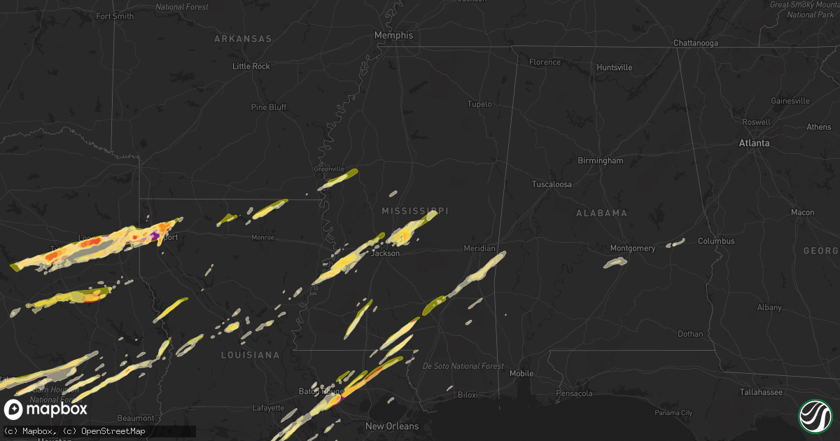
Hail Map in Mississippi on February 11, 2024
Get this storm
February 11 map
$229
one time, instant access
Download today. No call, no setup
Keep the $229
Bought the map and want the full workflow? Apply the entire $229 to a subscription within 7 days. None of it is wasted.
Every map, not just this one
This buys you this map. Subscription and you get every map we run, in the markets you choose from a few cities to whole states to nationwide. Plus real-time alerts the moment a storm fires.
Contact data
Name, contact info, occupancy, even credit band for addresses in the footprint. You go from where it hit to who to call.
Become the source they trust
Unlimited branding weather history reports on demand. You already have the documented answer ready for the property owner, and you are the one who showed up with it.
Property data and RoofTrace estimates
Pull up any address you have got, its value and the exact code rules for that jurisdiction, straight from One Click Code. Then RoofTrace estimates the squares, pitch, and roof value, priced the way you price.
Storm reports in Mississippi
Mississippi
| Date | Description |
|---|---|
| 02/11/20245:40 PM CST | A local report indicates 1.00 inch wind near Pocahontas |
| 02/11/20245:14 PM CST | Social media photo taken along dudley rd. |
| 02/11/20245:11 PM CST | Reported in the shiloh community. |
| 02/11/20242:40 PM CST | A tree was down blocking a roadway on billy fields road near dj johnson road. |
| 02/11/20242:40 PM CST | A tree was down blocking the road on raymond-bolton road near houston road. |
| 02/11/20242:20 PM CST | Tree downed over hoy rd. |
| 02/11/202412:44 PM CST | Dime to quarter sized hail fell. |
| 02/11/202412:55 AM CST | Report of quarter size hail. Report relayed to broadcast media via public. |
| 02/11/202412:30 AM CST | Video submitted via social media. |
| 02/11/202412:25 AM CST | Occurred along us 84 west of brookhaven. |
| 02/11/202412:22 AM CST | Report via social media. |
| 02/10/202411:56 PM CST | Hail larger than a quarter along ms highway 13 north of columbia. |
| 02/10/202411:55 PM CST | Ping pong to golfball size hail near foxworth. |
| 02/10/202411:36 PM CST | Photos/report from the public and local county em of damage to tylertown high school. Pictures indicate roof damage. Also report of trees down. Time estimated from rada |
| 02/10/202410:45 PM CST | Report via social media. Quarter to golfball size hail near sandy hook. |
| 02/10/20246:30 PM CST | A local report indicates 1.75 inch wind near 2 NNW Goshen Springs |
All States Impacted by Hail Map on February 11, 2024
Cities Impacted by Hail Map on February 11, 2024
- Tyler, TX
- Arp, TX
- Winona, TX
- Overton, TX
- Kilgore, TX
- Gladewater, TX
- Longview, TX
- Elkhart, TX
- Palestine, TX
- Troup, TX
- Henderson, TX
- Tatum, TX
- Beckville, TX
- Marshall, TX
- Hallsville, TX
- Rosanky, TX
- Smithville, TX
- Flatonia, TX
- Waskom, TX
- Karnack, TX
- Grapeland, TX
- Rusk, TX
- Alto, TX
- Cushing, TX
- Douglass, TX
- West Point, TX
- La Grange, TX
- Greenwood, LA
- College Station, TX
- Navasota, TX
- Anderson, TX
- Flint, TX
- Frankston, TX
- Whitehouse, TX
- Bullard, TX
- Larue, TX
- Chandler, TX
- Brownsboro, TX
- Murchison, TX
- Athens, TX
- Fayetteville, TX
- Ledbetter, TX
- Round Top, TX
- Shreveport, LA
- Mooringsport, LA
- Blanchard, LA
- Trinidad, TX
- Malakoff, TX
- Bossier City, LA
- Richards, TX
- Bedias, TX
- Huntsville, TX
- Barksdale Afb, LA
- Benton, LA
- Haughton, LA
- Kerens, TX
- Minden, LA
- Cotton Valley, LA
- Montgomery, TX
- Garrison, TX
- Nacogdoches, TX
- Oakhurst, TX
- Pointblank, TX
- Onalaska, TX
- Livingston, TX
- Arcadia, LA
- Dubach, LA
- Bernice, LA
- Moscow, TX
- Many, LA
- Robeline, LA
- Natchitoches, LA
- Marthaville, LA
- Gary, TX
- Joaquin, TX
- Price, TX
- Mansfield, LA
- Converse, LA
- Long Branch, TX
- Belmont, LA
- Tenaha, TX
- Mount Enterprise, TX
- Pleasant Hill, LA
- Carthage, TX
- Selman City, TX
- Logansport, LA
- Farmerville, LA
- Timpson, TX
- Saline, LA
- Marion, LA
- Bastrop, LA
- Goldonna, LA
- Plantersville, TX
- New Waverly, TX
- Princeton, LA
- Jacksonville, TX
- Oakwood, TX
- Muldoon, TX
- Buffalo, TX
- Belcher, LA
- Oil City, LA
- Somerville, TX
- De Berry, TX
- Hemphill, TX
- Coldspring, TX
- Willis, TX
- Corrigan, TX
- Downsville, LA
- Frierson, LA
- Bethany, LA
- Shepherd, TX
- Goodrich, TX
- Greenville, MS
- Hollandale, MS
- Indianola, MS
- Cleveland, TX
- Inverness, MS
- Leland, MS
- Saratoga, TX
- Warren, TX
- Burkeville, TX
- Newton, TX
- Wiergate, TX
- Hillister, TX
- Fred, TX
- Woodville, TX
- Spurger, TX
- Leesville, LA
- Fort Polk, LA
- Alexandria, LA
- Eudora, AR
- Pollock, LA
- Bentley, LA
- Dry Prong, LA
- Lexington, MS
- Broaddus, TX
- Chester, TX
- Boyce, LA
- Zavalla, TX
- Colfax, LA
- Colmesneil, TX
- Lena, LA
- Pitkin, LA
- Hineston, LA
- Jasper, TX
- Tuskegee, AL
- Hardaway, AL
- Tuskegee Institute, AL
- Kirbyville, TX
- Deridder, LA
- Hayneville, AL
- Letohatchee, AL
- Hope Hull, AL
- Parkdale, AR
- Newellton, LA
- Saint Joseph, LA
- Port Gibson, MS
- Vicksburg, MS
- Edwards, MS
- Utica, MS
- Bolton, MS
- Clinton, MS
- Jackson, MS
- Flora, MS
- Madison, MS
- Canton, MS
- Carthage, MS
- Camden, MS
- Brandon, MS
- Lena, MS
- Plaquemine, LA
- White Castle, LA
- Clayton, LA
- Ferriday, LA
- Tallulah, LA
- Shubuta, MS
- Quitman, MS
- Vossburg, MS
- New Iberia, LA
- Abbeville, LA
- Pineville, LA
- Elmer, LA
- Pachuta, MS
- Auburn, AL
- Ridgeland, MS
- Hermanville, MS
- Raymond, MS
- Jonesville, LA
- Deville, LA
- Center Point, LA
- Lowndesboro, AL
- Effie, LA
- Sicily Island, LA
- Harrisonburg, LA
- Monterey, LA
- Walnut Grove, MS
- Waterproof, LA
- Lecompte, LA
- Otis, LA
- Sieper, LA
- Silsbee, TX
- Saint Gabriel, LA
- Sunshine, LA
- Walker, LA
- Livingston, LA
- Holden, LA
- Independence, LA
- Amite, LA
- Franklinton, LA
- Tylertown, MS
- Denham Springs, LA
- Pine Grove, LA
- Sandy Hook, MS
- Franklin, LA
- Jeanerette, LA
- Kokomo, MS
- Foxworth, MS
- Columbia, MS
- Carville, LA
- Geismar, LA
- Prairieville, LA
- Bassfield, MS
- Sumrall, MS
- Seminary, MS
- Collins, MS
- Liberty, MS
- Smithdale, MS
- McCall Creek, MS
- Bogue Chitto, MS
- Brookhaven, MS
- Wesson, MS
- Ellisville, MS
- Soso, MS
- Laurel, MS
- Lumberton, MS
- Hattiesburg, MS
- Poplarville, MS
- Purvis, MS
- Baton Rouge, LA
- Gonzales, LA
- Albany, LA
- Tickfaw, LA
- Hammond, LA
- Loranger, LA
- Husser, LA
- Angie, LA
- Port Allen, LA
- Fluker, LA
- Kentwood, LA
- Saint Martinville, LA
- Greenwell Springs, LA
- Columbiana, AL
- Montevallo, AL
- Alabaster, AL
- Loreauville, LA
- Morgan City, LA
- Mount Hermon, LA
- Addis, LA
- Brusly, LA
- Napoleonville, LA
- Richton, MS
- Berwick, LA
- Gibson, LA
- Theriot, LA
- Patterson, LA
- Meridian, MS
- Butler, AL
- Lisman, AL
- Heidelberg, MS
- Mandeville, LA
- Lacombe, LA
- Thibodaux, LA
- Westwego, LA
- New Orleans, LA
- Marrero, LA
- Belle Rose, LA
- Pierre Part, LA
- Plattenville, LA
- Osyka, MS
- Saint James, LA
- Waynesboro, MS
- Mccomb, MS
- Magnolia, MS
- Ball, LA
- Bogalusa, LA
- Pelahatchie, MS
- Chatom, AL
- Morton, MS
- Gulfport, MS


