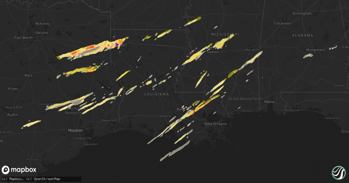
Hail Map in Louisiana on February 11, 2024
Get this storm
February 11 map
$229
one time, instant access
Download today. No call, no setup
Keep the $229
Bought the map and want the full workflow? Apply the entire $229 to a subscription within 7 days. None of it is wasted.
Every map, not just this one
This buys you this map. Subscription and you get every map we run, in the markets you choose from a few cities to whole states to nationwide. Plus real-time alerts the moment a storm fires.
Contact data
Name, contact info, occupancy, even credit band for addresses in the footprint. You go from where it hit to who to call.
Become the source they trust
Unlimited branding weather history reports on demand. You already have the documented answer ready for the property owner, and you are the one who showed up with it.
Property data and RoofTrace estimates
Pull up any address you have got, its value and the exact code rules for that jurisdiction, straight from One Click Code. Then RoofTrace estimates the squares, pitch, and roof value, priced the way you price.
Storm reports in Louisiana
Louisiana
| Date | Description |
|---|---|
| 02/11/20244:50 PM CST | Media reported multiple hail reports of 1 to 1.25 inches. |
| 02/11/20244:40 PM CST | Photo received of tree blown down onto fence in pineville. Time estimated by radar. |
| 02/11/20244:29 PM CST | Public reports quarter size hail. |
| 02/11/20243:25 PM CST | Social media video shows nickel to quarter size hail. Video not in the core of the storm. |
| 02/11/20242:35 PM CST | Report of hail from twitter. |
| 02/11/202412:10 PM CST | A couple trees were snapped near girard. |
| 02/11/202411:19 AM CST | A local report indicates 1.00 inch wind near 1 WNW Beekman |
| 02/11/202411:18 AM CST | Report from em with supporting picture. |
| 02/11/202410:50 AM CST | Hail near quarter size reported near the linville community. |
| 02/11/20249:30 AM CST | Delayed report. |
| 02/11/20249:17 AM CST | Report from mping: hen egg |
| 02/11/20249:15 AM CST | Nws employee measured 1 inch hail off lost river dr. Near benton... Louisiana. |
| 02/11/20249:15 AM CST | Hail lasted about 2 min. Measured 3 in hail with ruler. |
| 02/11/20249:15 AM CST | Report through social media. |
| 02/11/20249:15 AM CST | Quarter sized hail in north bossier. |
| 02/11/20249:13 AM CST | Awos station kbad barksdale afb. |
| 02/11/20249:13 AM CST | Report from mping: ping pong ball |
| 02/11/20249:10 AM CST | Golf ball sized hail reported on the southeast side of cypress lake. |
| 02/11/20249:03 AM CST | Report from mping: ping pong ball |
| 02/11/20249:01 AM CST | Reports of 2 inch hail near cross lake. |
| 02/11/20249:00 AM CST | Asos station kshv shreveport regional airport. |
| 02/11/20248:50 AM CST | Hail measured in blanchard... Louisiana. |
| 02/11/20248:50 AM CST | Golf ball sized hail reported at the ksla studios on north line avenue. |
| 02/11/20244:15 AM CST | Gao |
| 02/11/20241:23 AM CST | Mping report of 1 inch hail near franklinton. Time estimated from radar. |
| 02/11/202412:37 AM CST | Multiple trees and power lines down along n. Montpelier rd between jacob st and sziszak st. |
| 02/11/202412:34 AM CST | Photo from the public of around ping pong ball sized hail... Estimated. Time estimated from radar. |
| 02/11/202412:28 AM CST | Estimated hail size. Tree limbs also broken. |
| 02/11/202412:19 AM CST | Social media report of golf ball sized hail in port vincent. |
| 02/11/202412:16 AM CST | Social media report of quarter to golf ball sized hail between walker and port vincent. |
| 02/11/202412:10 AM CST | Photo of hail in various sizes next to a penny... Quarter... Ping pong ball and ruler. Largest hail stone is oddly shaped and may be upwards of 2 inches in diameter or |
| 02/11/202412:07 AM CST | Report from mping: quarter |
| 02/11/202412:07 AM CST | Picture of golf ball sized hail by prairieville high school. Time estimated from radar. |
| 02/11/202412:05 AM CST | 1.5 inch hail |
| 02/11/202412:02 AM CST | Photo of hail... Estimated to be around quarter sized. Location in prairieville off highway 73. Time estimated from radar. |
| 02/10/202411:13 PM CST | Picture sent by em. |
| 02/10/202410:25 PM CST | Quarter sized hail starting approx. 10:25 pm lasting for roughly 10 minutes. |
| 02/10/20249:44 PM CST | Public report from livingston of quarter-sized hail... Winds estimated 40mph and power out. |
| 02/10/20249:14 PM CST | Power outages reported in the community of lydia. Outage occurred at the time of large hail core falling out of storm. |
| 02/10/20248:19 PM CST | Corrects time of previous tstm wnd dmg report from 1 sse lydia. Power outages reported in the community of lydia. Outage occurred at the time of large hail core falling |
All States Impacted by Hail Map on February 11, 2024
Cities Impacted by Hail Map on February 11, 2024
- Tyler, TX
- Arp, TX
- Winona, TX
- Overton, TX
- Kilgore, TX
- Gladewater, TX
- Longview, TX
- Elkhart, TX
- Palestine, TX
- Troup, TX
- Henderson, TX
- Tatum, TX
- Beckville, TX
- Marshall, TX
- Hallsville, TX
- Rosanky, TX
- Smithville, TX
- Flatonia, TX
- Waskom, TX
- Karnack, TX
- Grapeland, TX
- Rusk, TX
- Alto, TX
- Cushing, TX
- Douglass, TX
- West Point, TX
- La Grange, TX
- Greenwood, LA
- College Station, TX
- Navasota, TX
- Anderson, TX
- Flint, TX
- Frankston, TX
- Whitehouse, TX
- Bullard, TX
- Larue, TX
- Chandler, TX
- Brownsboro, TX
- Murchison, TX
- Athens, TX
- Fayetteville, TX
- Ledbetter, TX
- Round Top, TX
- Shreveport, LA
- Mooringsport, LA
- Blanchard, LA
- Trinidad, TX
- Malakoff, TX
- Bossier City, LA
- Richards, TX
- Bedias, TX
- Huntsville, TX
- Barksdale Afb, LA
- Benton, LA
- Haughton, LA
- Kerens, TX
- Minden, LA
- Cotton Valley, LA
- Montgomery, TX
- Garrison, TX
- Nacogdoches, TX
- Oakhurst, TX
- Pointblank, TX
- Onalaska, TX
- Livingston, TX
- Arcadia, LA
- Dubach, LA
- Bernice, LA
- Moscow, TX
- Many, LA
- Robeline, LA
- Natchitoches, LA
- Marthaville, LA
- Gary, TX
- Joaquin, TX
- Price, TX
- Mansfield, LA
- Converse, LA
- Long Branch, TX
- Belmont, LA
- Tenaha, TX
- Mount Enterprise, TX
- Pleasant Hill, LA
- Carthage, TX
- Selman City, TX
- Logansport, LA
- Farmerville, LA
- Timpson, TX
- Saline, LA
- Marion, LA
- Bastrop, LA
- Goldonna, LA
- Plantersville, TX
- New Waverly, TX
- Princeton, LA
- Jacksonville, TX
- Oakwood, TX
- Muldoon, TX
- Buffalo, TX
- Belcher, LA
- Oil City, LA
- Somerville, TX
- De Berry, TX
- Hemphill, TX
- Coldspring, TX
- Willis, TX
- Corrigan, TX
- Downsville, LA
- Frierson, LA
- Bethany, LA
- Shepherd, TX
- Goodrich, TX
- Greenville, MS
- Hollandale, MS
- Indianola, MS
- Cleveland, TX
- Inverness, MS
- Leland, MS
- Saratoga, TX
- Warren, TX
- Burkeville, TX
- Newton, TX
- Wiergate, TX
- Hillister, TX
- Fred, TX
- Woodville, TX
- Spurger, TX
- Leesville, LA
- Fort Polk, LA
- Alexandria, LA
- Eudora, AR
- Pollock, LA
- Bentley, LA
- Dry Prong, LA
- Lexington, MS
- Broaddus, TX
- Chester, TX
- Boyce, LA
- Zavalla, TX
- Colfax, LA
- Colmesneil, TX
- Lena, LA
- Pitkin, LA
- Hineston, LA
- Jasper, TX
- Tuskegee, AL
- Hardaway, AL
- Tuskegee Institute, AL
- Kirbyville, TX
- Deridder, LA
- Hayneville, AL
- Letohatchee, AL
- Hope Hull, AL
- Parkdale, AR
- Newellton, LA
- Saint Joseph, LA
- Port Gibson, MS
- Vicksburg, MS
- Edwards, MS
- Utica, MS
- Bolton, MS
- Clinton, MS
- Jackson, MS
- Flora, MS
- Madison, MS
- Canton, MS
- Carthage, MS
- Camden, MS
- Brandon, MS
- Lena, MS
- Plaquemine, LA
- White Castle, LA
- Clayton, LA
- Ferriday, LA
- Tallulah, LA
- Shubuta, MS
- Quitman, MS
- Vossburg, MS
- New Iberia, LA
- Abbeville, LA
- Pineville, LA
- Elmer, LA
- Pachuta, MS
- Auburn, AL
- Ridgeland, MS
- Hermanville, MS
- Raymond, MS
- Jonesville, LA
- Deville, LA
- Center Point, LA
- Lowndesboro, AL
- Effie, LA
- Sicily Island, LA
- Harrisonburg, LA
- Monterey, LA
- Walnut Grove, MS
- Waterproof, LA
- Lecompte, LA
- Otis, LA
- Sieper, LA
- Silsbee, TX
- Saint Gabriel, LA
- Sunshine, LA
- Walker, LA
- Livingston, LA
- Holden, LA
- Independence, LA
- Amite, LA
- Franklinton, LA
- Tylertown, MS
- Denham Springs, LA
- Pine Grove, LA
- Sandy Hook, MS
- Franklin, LA
- Jeanerette, LA
- Kokomo, MS
- Foxworth, MS
- Columbia, MS
- Carville, LA
- Geismar, LA
- Prairieville, LA
- Bassfield, MS
- Sumrall, MS
- Seminary, MS
- Collins, MS
- Liberty, MS
- Smithdale, MS
- McCall Creek, MS
- Bogue Chitto, MS
- Brookhaven, MS
- Wesson, MS
- Ellisville, MS
- Soso, MS
- Laurel, MS
- Lumberton, MS
- Hattiesburg, MS
- Poplarville, MS
- Purvis, MS
- Baton Rouge, LA
- Gonzales, LA
- Albany, LA
- Tickfaw, LA
- Hammond, LA
- Loranger, LA
- Husser, LA
- Angie, LA
- Port Allen, LA
- Fluker, LA
- Kentwood, LA
- Saint Martinville, LA
- Greenwell Springs, LA
- Columbiana, AL
- Montevallo, AL
- Alabaster, AL
- Loreauville, LA
- Morgan City, LA
- Mount Hermon, LA
- Addis, LA
- Brusly, LA
- Napoleonville, LA
- Richton, MS
- Berwick, LA
- Gibson, LA
- Theriot, LA
- Patterson, LA
- Meridian, MS
- Butler, AL
- Lisman, AL
- Heidelberg, MS
- Mandeville, LA
- Lacombe, LA
- Thibodaux, LA
- Westwego, LA
- New Orleans, LA
- Marrero, LA
- Belle Rose, LA
- Pierre Part, LA
- Plattenville, LA
- Osyka, MS
- Saint James, LA
- Waynesboro, MS
- Mccomb, MS
- Magnolia, MS
- Ball, LA
- Bogalusa, LA
- Pelahatchie, MS
- Chatom, AL
- Morton, MS
- Gulfport, MS


