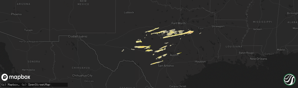
Hail Map in Texas on February 10, 2024
The weather event in Texas on February 10, 2024 includes Hail and Wind maps. 1 state and 143 cities were impacted and suffered possible damage. The total estimated number of properties impacted is 34,497.
Want more than just the map?
Turn this storm into a full workflow.
- Owner + property data so you know who to knock
- OnDemand branded weather history reports to win the "did we even have hail?" argument
- RoofTrace estimate so reps stop guessing numbers at the door
Bought this map? Upgrade within 7 days and we'll credit the $230. (10-15 min setup call)
Hail
Wind
34,497
Estimated number of impacted properties by a 1.00" hail or larger3,998
Estimated number of impacted properties by a 1.75" hail or larger0
Estimated number of impacted properties by a 2.50" hail or largerStorm reports in Texas
Texas
| Date | Description |
|---|---|
| 02/10/20249:52 AM CST | A local report indicates 1.00 inch wind near 4 ESE Elgin |
| 02/10/20247:03 AM CST | Viewer report via ksat of hail on the northwest side of boerne near northview drive and ranger creek. Time estimated via radar. |
| 02/10/20245:35 AM CST | Golfball sized hail in mildred. |
| 02/10/20245:22 AM CST | Report from mping: quarter |
| 02/10/20245:20 AM CST | Ping-pong size hail reported near corbet... Southwest of corsicana. |
| 02/10/20245:02 AM CST | Local em reported quarter size hail at navarro mills lake. |
| 02/10/20244:51 AM CST | Public report quarter size hail in malone. |
| 02/10/20244:00 AM CST | Social media report of quarter size hail in clifton. |
| 02/10/20243:16 AM CST | Social media reports of quarter to half dollar size hail in hamilton. |
| 02/10/20242:15 AM CST | Reported via facebook. Time estimated based on radar. Also reported some window damage from the hail. |
| 02/10/20241:05 AM CST | Facebook report of quarter size hail in silver valley. |
| 02/10/202412:40 AM CST | Facebook report of golf ball size hail in ozona. |
| 02/09/202411:45 PM CST | Quarter size hail was reported in grape creek. |
| 02/09/202411:30 PM CST | A local report indicates 1.00 inch wind near 3 E Dudley |
| 02/09/202411:03 PM CST | Report from mping: quarter |
All States Impacted by Hail Map on February 10, 2024
Cities Impacted by Hail Map on February 10, 2024
- Boerne, TX
- Elgin, TX
- Lexington, TX
- Bandera, TX
- Comfort, TX
- Kerrville, TX
- Junction, TX
- Uvalde, TX
- D Hanis, TX
- Utopia, TX
- Pipe Creek, TX
- Medina, TX
- Tarpley, TX
- Concan, TX
- Hondo, TX
- McDade, TX
- Mason, TX
- Castell, TX
- Llano, TX
- Buchanan Dam, TX
- Fredericksburg, TX
- Stonewall, TX
- Hye, TX
- Johnson City, TX
- Hunt, TX
- Valley Spring, TX
- Bluffton, TX
- Kempner, TX
- Lampasas, TX
- Blanco, TX
- Killeen, TX
- Tow, TX
- Cherokee, TX
- San Saba, TX
- Burnet, TX
- Center Point, TX
- Waco, TX
- Harper, TX
- Doss, TX
- Art, TX
- Tuscola, TX
- Ovalo, TX
- Winters, TX
- Lawn, TX
- Abilene, TX
- Clyde, TX
- Mertzon, TX
- Barnhart, TX
- Baird, TX
- San Angelo, TX
- Cisco, TX
- Ozona, TX
- Eldorado, TX
- Talpa, TX
- Novice, TX
- Coleman, TX
- Burkett, TX
- Christoval, TX
- Cross Plains, TX
- Menard, TX
- Fort McKavett, TX
- Brownwood, TX
- Rising Star, TX
- Fort Stockton, TX
- Norton, TX
- Bronte, TX
- Blackwell, TX
- Wingate, TX
- Albany, TX
- Lueders, TX
- May, TX
- Comanche, TX
- De Leon, TX
- Gorman, TX
- Mullin, TX
- Priddy, TX
- Hamilton, TX
- Pottsville, TX
- Sonora, TX
- London, TX
- Hico, TX
- Jonesboro, TX
- Cranfills Gap, TX
- Clifton, TX
- Meridian, TX
- Whitney, TX
- Aquilla, TX
- Hillsboro, TX
- Abbott, TX
- Walnut Springs, TX
- Iredell, TX
- Morgan, TX
- Malone, TX
- Penelope, TX
- Bynum, TX
- Frost, TX
- Hubbard, TX
- Purdon, TX
- Barry, TX
- Dawson, TX
- Corsicana, TX
- Powell, TX
- Kerens, TX
- Malakoff, TX
- Trinidad, TX
- Athens, TX
- Larue, TX
- Chandler, TX
- Flint, TX
- Tyler, TX
- Brookesmith, TX
- Dublin, TX
- Goldthwaite, TX
- Richland, TX
- Jacksonville, TX
- Lometa, TX
- Glen Rose, TX
- Blanket, TX
- Kopperl, TX
- West, TX
- Bluff Dale, TX
- Stephenville, TX
- Carlton, TX
- Gustine, TX
- Zephyr, TX
- Early, TX
- Sidney, TX
- Rainbow, TX
- Nemo, TX
- Blum, TX
- Cleburne, TX
- Brownsboro, TX
- Wortham, TX
- Chatfield, TX
- Breckenridge, TX
- Italy, TX
- Milford, TX
- Itasca, TX
- Blooming Grove, TX
- Streetman, TX
- Mertens, TX
- Covington, TX
- Carbon, TX


