Hail Map in Hattiesburg, MS on February 10, 2013
The weather event in Hattiesburg, MS on February 10, 2013 includes Hail map. 6 states and 209 cities were impacted and suffered possible damage. The total estimated number of properties impacted is 0.
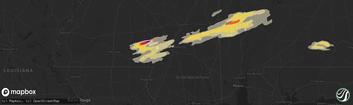
Hail
0
Estimated number of impacted properties by a 1.00" hail or larger0
Estimated number of impacted properties by a 1.75" hail or larger0
Estimated number of impacted properties by a 2.50" hail or largerStorm reports in Hattiesburg, MS
Hattiesburg, MS
| Date | Description |
|---|---|
| 02/10/20135:21 PM CST | *** 63 inj *** substantial damage across the city of hattiesburg. Roughly 300 homes and buildings damaged with debris blocking nearly 100 roadways. Approximately 63 inj |
| 02/10/20135:15 PM CST | Oak grove high school and baseball fields majorly damaged. |
| 02/10/20135:12 PM CST | *** 19 inj *** tornadic damage reported across the county with 19 injured and were sent to area hospitals...2 critical. |
| 02/10/20135:06 PM CST | *** 19 inj *** this tornado started on the west side of oak grove...low end ef4 damage occurred near the high school and to a housing area just to the sw of that locati |
All Cities Impacted by Hail Map on February 10, 2013
- Bonita, LA
- Jones, LA
- Foxworth, MS
- Carson, MS
- Columbia, MS
- Oak Vale, MS
- Freer, TX
- San Diego, TX
- Morton, MS
- Lena, MS
- Fort Gaines, GA
- Shorterville, AL
- Forest, MS
- Laurel, MS
- Ovett, MS
- Ellisville, MS
- Utica, MS
- Shubuta, MS
- Melvin, AL
- Gilbertown, AL
- Waynesboro, MS
- Three Rivers, TX
- Sumrall, MS
- Moreauville, LA
- Marksville, LA
- Ethel, MS
- Itta Bena, MS
- Belzoni, MS
- Deville, LA
- Pineville, LA
- Evergreen, LA
- Jacksonville, TX
- Troup, TX
- Evergreen, AL
- Valley Park, MS
- Tilden, TX
- Leona, TX
- Osyka, MS
- Mccomb, MS
- Tylertown, MS
- Magnolia, MS
- Silver Creek, MS
- Nacogdoches, TX
- Canton, MS
- Brandon, MS
- Frankville, AL
- Richton, MS
- Thomasville, AL
- Silas, AL
- Buckatunna, MS
- Coffeeville, AL
- Chatom, AL
- Millry, AL
- Smithdale, MS
- Liberty, MS
- Gloster, MS
- Laredo, TX
- Prentiss, MS
- State Line, MS
- Saint Stephens, AL
- Jackson, AL
- Petal, MS
- Lower Peach Tree, AL
- Pine Hill, AL
- Grove Hill, AL
- Woodville, MS
- Centreville, MS
- Woodville, TX
- Livingston, TX
- Chester, TX
- Colmesneil, TX
- Realitos, TX
- Lexington, MS
- Durant, MS
- Pickens, MS
- Andalusia, AL
- Opp, AL
- Red Level, AL
- Encinal, TX
- Madison, MS
- Flora, MS
- Needham, AL
- Gilbert, LA
- Bassfield, MS
- Sandy Hook, MS
- Hattiesburg, MS
- Kokomo, MS
- Moselle, MS
- Purvis, MS
- Jayess, MS
- Monticello, MS
- Lumberton, MS
- Seminary, MS
- Cotulla, TX
- Yazoo City, MS
- Goodman, MS
- Benton, MS
- Oakwood, TX
- Grapeland, TX
- Buffalo, TX
- McCall Creek, MS
- Summit, MS
- Newville, AL
- Headland, AL
- Fowlerton, TX
- McCool, MS
- Carthage, MS
- Mansfield, LA
- Calliham, TX
- Bentonia, MS
- Bolton, MS
- Damascus, GA
- Arlington, GA
- Midland City, AL
- Columbia, AL
- Abbeville, AL
- Blakely, GA
- Sallis, MS
- West, MS
- Moorhead, MS
- Sunflower, MS
- Isola, MS
- Indianola, MS
- Inverness, MS
- Moscow, TX
- Wells, TX
- Rolling Fork, MS
- Philadelphia, MS
- Fort Necessity, LA
- Vicksburg, MS
- Raymond, MS
- Crossett, AR
- Jasper, TX
- Rose Hill, MS
- Enterprise, MS
- Florence, MS
- Toxey, AL
- Whatley, AL
- Dickinson, AL
- Franklin, AL
- Coy, AL
- Orrville, AL
- Minter, AL
- Enterprise, LA
- Harrisonburg, LA
- Schlater, MS
- Ozark, AL
- Ridgeland, MS
- Center, TX
- Timpson, TX
- Joaquin, TX
- Logansport, LA
- Tenaha, TX
- Port Gibson, MS
- Hermanville, MS
- George West, TX
- Concepcion, TX
- Zavalla, TX
- Centerville, TX
- Waterproof, LA
- Clayton, LA
- Brookhaven, MS
- Terry, MS
- Edwards, MS
- Pitkin, LA
- Normangee, TX
- Butler, AL
- Garrison, TX
- Bogue Chitto, MS
- Bastrop, LA
- Cheneyville, LA
- Saint Landry, LA
- Wisner, LA
- Fayette, MS
- Mount Enterprise, TX
- Louise, MS
- Silver City, MS
- Kosciusko, MS
- Olla, LA
- Ruth, MS
- Saint Francisville, LA
- Angie, LA
- Elkhart, TX
- Crockett, TX
- Redwood, MS
- Satartia, MS
- Hazlehurst, MS
- Meadville, MS
- Union Church, MS
- Comanche, TX
- Mullin, TX
- Zephyr, TX
- Hamilton, TX
- Priddy, TX
- Early, TX
- Rising Star, TX
- Burkett, TX
- Cross Plains, TX
- Coleman, TX
- Gorman, TX
- Desdemona, TX
- Carbon, TX
- Buchanan Dam, TX
- Burnet, TX
- Kingsland, TX
- Christoval, TX
- San Angelo, TX
- Vancourt, TX
- Eden, TX


