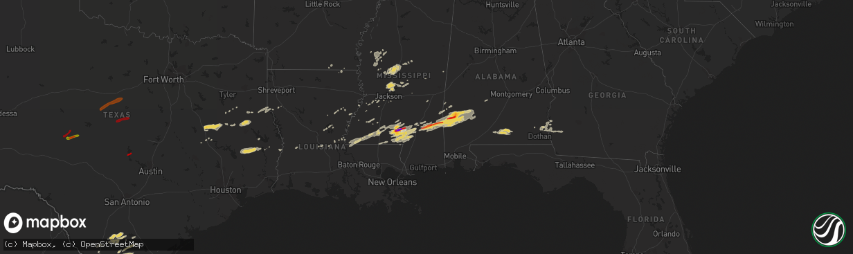
Hail Map on February 10, 2013
The weather event on February 10, 2013 includes Hail map. 6 states and 209 cities were impacted and suffered possible damage. The total estimated number of properties impacted is 2,418.
Want more than just the map?
Turn this storm into a full workflow.
- Owner + property data so you know who to knock
- OnDemand branded weather history reports to win the "did we even have hail?" argument
- RoofTrace estimate so reps stop guessing numbers at the door
Bought this map? Upgrade within 7 days and we'll credit the $230. (10-15 min setup call)
Hail
2,418
Estimated number of impacted properties by a 1.00" hail or larger6,239
Estimated number of impacted properties by a 1.75" hail or larger226
Estimated number of impacted properties by a 2.50" hail or largerStorm reports
Alabama
| Date | Description |
|---|---|
| 02/10/20135:33 PM CST | A local report indicates a tornado near MAYS CROSSROADS |
| 02/10/20135:27 PM CST | 2 homes damage in the antioch community near hwy 43 and toddtown road. 2 homes damaged on maubila road. |
| 02/10/20135:27 PM CST | Emergency manager reports debris on highway 43 near antioch. Likely tornado. |
| 02/10/20135:10 PM CST | 4 to 6 residences suffered major damage or were destroyed on old lock one road. No injuries reported. |
| 02/10/20135:05 PM CST | Roof of homw co rd 34. 12 x 16 building distroyed |
| 02/10/20132:30 AM CST | Wind damage to two homes on crestview road in thomasville. Reported by calrke coounty ema |
| 02/10/201312:13 AM CST | Trees reported down across the county. Time estimated by radar. |
| 02/09/20138:20 PM CST | Trees and power lines down across county. |
| 02/09/20138:13 PM CST | Several trees and power lines down across county. Time estimated off of radar. |
| 02/09/20138:12 PM CST | A local report indicates 58 MPH wind near HANCHEY FIELD |
| 02/09/20138:00 PM CST | Several trees down across northern half of county |
| 02/09/20136:00 PM CST | Golf ball size hail and trees down in coffeeville. |
Arkansas
| Date | Description |
|---|---|
| 02/10/20138:55 AM CST | Tree down in crossett |
| 02/10/20138:54 AM CST | Nickel to quarter sized hail around crossett. |
Louisiana
| Date | Description |
|---|---|
| 02/10/20132:00 PM CST | Tree down in town |
| 02/10/20131:25 PM CST | Tree down in town |
| 02/10/201311:25 AM CST | Tree and power line down |
| 02/10/201311:25 AM CST | Tree and power line down in bynum 5 south of colfax |
| 02/10/201310:47 AM CST | Power lines down |
Mississippi
| Date | Description |
|---|---|
| 02/10/20135:43 PM CST | Hail likely larger based off nearby reports. |
| 02/10/20135:40 PM CST | Baseball to possibly softball sized hail in and around goss. |
| 02/10/20135:23 PM CST | Considerable damage to a hardware store in petal. Multiple homes damaged in the area. Possible injuries. |
| 02/10/20135:21 PM CST | *** 63 inj *** substantial damage across the city of hattiesburg. Roughly 300 homes and buildings damaged with debris blocking nearly 100 roadways. Approximately 63 inj |
| 02/10/20135:15 PM CST | Oak grove high school and baseball fields majorly damaged. |
| 02/10/20135:12 PM CST | *** 19 inj *** tornadic damage reported across the county with 19 injured and were sent to area hospitals...2 critical. |
| 02/10/20135:06 PM CST | *** 19 inj *** this tornado started on the west side of oak grove...low end ef4 damage occurred near the high school and to a housing area just to the sw of that locati |
| 02/10/20134:50 PM CST | Home destroyed on whiley lott rd...near the marion...lamar co line. |
| 02/10/20134:48 PM CST | Five homes were damaged along prospres ridge road near the marion/lamar county border. |
| 02/10/20134:38 PM CST | A local report indicates 1.00 inch wind near ARM |
| 02/10/20134:28 PM CST | *** 5 inj *** homes damaged along mt carmel church rd and regan rd. 5 injuries reported along the path so far. |
| 02/10/20134:25 PM CST | *** 3 inj *** tornado started along new hope rd...the most substantial damage was along mt carmel church rd and regan rd. The tornado continued across marion co and end |
| 02/10/20134:15 PM CST | A couple of trees were blown down. Time based on radar. |
| 02/10/20133:42 PM CST | A home was damaged and trees and powerlines were downed along gw smith rd. Possible tornado. |
| 02/10/20133:42 PM CST | Three homes damaged along with several barns damaged. Numerous trees and powerlines were downed along gw smith rd. |
| 02/10/20133:39 PM CST | Ef1 tornado began in a wooded area between river rd and gw smith rd. Snapped and uprooted dozens of trees along gw smith rd. A few hay barns were damaged. A mobile home |
| 02/10/20133:10 PM CST | Tree down along hwy 27 |
| 02/10/20132:15 PM CST | Public report of quarter size hail relayed by gloster pd. |
| 02/10/20131:40 PM CST | Power lines down |
| 02/10/20131:35 PM CST | Power line down |
| 02/10/201311:55 AM CST | Power lines down |
| 02/10/201311:51 AM CST | Trees down across hwy 14w |
| 02/10/201311:50 AM CST | Few older trees blown down. |
| 02/10/201311:38 AM CST | Trees and power lines down around flora...also scattered trees down across much of sw madison county. |
| 02/10/201311:35 AM CST | Power lines down. |
| 02/10/201311:15 AM CST | Several power lines down on floweree rd. |
| 02/10/201311:08 AM CST | Tree down across carson rd |
| 02/10/201310:56 AM CST | Some trees had tops broken off. An additional report of numerous trees down. |
| 02/10/201310:49 AM CST | Barn destroyed along hwy 149 |
| 02/09/201311:12 PM CST | Dime to quarter size hail fell. |
| 02/09/20137:18 PM CST | Trailer blown off its blocks and a roof off of a home on denham progress road. Injuries have been reported but the number is unknown at this time. Multiple trees and po |
| 02/09/20137:05 PM CST | Tornado reported near clara. Home damaged on highway 63. Trees down on hudson town road |
Texas
| Date | Description |
|---|---|
| 02/10/20139:37 AM CST | Trees down along 190 east of livingston. |
| 02/10/20139:36 AM CST | Travel trailer destroyed on east side of livingston. |
| 02/10/20139:15 AM CST | *** 1 inj *** an ef-0 tornado with a path length of 0.6 miles and a path width of 30 yards. A travel trailer was destroyed when tornadic winds lofted it over power line |
| 02/10/20136:11 AM CST | Telephone pole snapped in half. Power lines down. |
| 02/10/20133:40 AM CST | Quarter to golfball sized hail reported just north of freer. Hail depth on the ground was 2-3 inches. |
| 02/10/20133:40 AM CST | Freer fire department reports roof damage to home and business in freer. Several tin sheds damaged as well as powerlines down. Power out in the city. Additional reports |
| 02/10/20133:40 AM CST | 60 mph straight line wind swept through freer. Nws storm survey team reported a couple of structures lost their roof. Large trees down. One house under construction wit |
| 02/10/20133:00 AM CST | Cocorahs observer relayed a report of severe roof damage to a 5000 square foot warehouse...deer blinds blown over...and shingles blown off of a home at callaghan ranch. |
| 02/10/20133:00 AM CST | Cocorahs observer relayed a report of golfball sized hail at callaghan ranch. |
| 02/10/20132:45 AM CST | Cocorahs observer reported that tree branches were blown off trees at callaghan ranch. The diameter of the tree branches was around eight inches. |
| 02/10/20132:45 AM CST | Cocorahs observer reported golf ball sized hail at callaghan ranch which lasted for around 10 minutes. |
| 02/10/20132:40 AM CST | U.s. Border patrol checkpoint reported quarter sized hail. |
Cities Impacted by Hail Map on February 10, 2013
- Bonita, LA
- Jones, LA
- Foxworth, MS
- Carson, MS
- Columbia, MS
- Oak Vale, MS
- Freer, TX
- San Diego, TX
- Morton, MS
- Lena, MS
- Fort Gaines, GA
- Shorterville, AL
- Forest, MS
- Laurel, MS
- Ovett, MS
- Ellisville, MS
- Utica, MS
- Shubuta, MS
- Melvin, AL
- Gilbertown, AL
- Waynesboro, MS
- Three Rivers, TX
- Sumrall, MS
- Moreauville, LA
- Marksville, LA
- Ethel, MS
- Itta Bena, MS
- Belzoni, MS
- Deville, LA
- Pineville, LA
- Evergreen, LA
- Jacksonville, TX
- Troup, TX
- Evergreen, AL
- Valley Park, MS
- Tilden, TX
- Leona, TX
- Osyka, MS
- Mccomb, MS
- Tylertown, MS
- Magnolia, MS
- Silver Creek, MS
- Nacogdoches, TX
- Canton, MS
- Brandon, MS
- Frankville, AL
- Richton, MS
- Thomasville, AL
- Silas, AL
- Buckatunna, MS
- Coffeeville, AL
- Chatom, AL
- Millry, AL
- Smithdale, MS
- Liberty, MS
- Gloster, MS
- Laredo, TX
- Prentiss, MS
- State Line, MS
- Saint Stephens, AL
- Jackson, AL
- Petal, MS
- Lower Peach Tree, AL
- Pine Hill, AL
- Grove Hill, AL
- Woodville, MS
- Centreville, MS
- Woodville, TX
- Livingston, TX
- Chester, TX
- Colmesneil, TX
- Realitos, TX
- Lexington, MS
- Durant, MS
- Pickens, MS
- Andalusia, AL
- Opp, AL
- Red Level, AL
- Encinal, TX
- Madison, MS
- Flora, MS
- Needham, AL
- Gilbert, LA
- Bassfield, MS
- Sandy Hook, MS
- Hattiesburg, MS
- Kokomo, MS
- Moselle, MS
- Purvis, MS
- Jayess, MS
- Monticello, MS
- Lumberton, MS
- Seminary, MS
- Cotulla, TX
- Yazoo City, MS
- Goodman, MS
- Benton, MS
- Oakwood, TX
- Grapeland, TX
- Buffalo, TX
- McCall Creek, MS
- Summit, MS
- Newville, AL
- Headland, AL
- Fowlerton, TX
- McCool, MS
- Carthage, MS
- Mansfield, LA
- Calliham, TX
- Bentonia, MS
- Bolton, MS
- Damascus, GA
- Arlington, GA
- Midland City, AL
- Columbia, AL
- Abbeville, AL
- Blakely, GA
- Sallis, MS
- West, MS
- Moorhead, MS
- Sunflower, MS
- Isola, MS
- Indianola, MS
- Inverness, MS
- Moscow, TX
- Wells, TX
- Rolling Fork, MS
- Philadelphia, MS
- Fort Necessity, LA
- Vicksburg, MS
- Raymond, MS
- Crossett, AR
- Jasper, TX
- Rose Hill, MS
- Enterprise, MS
- Florence, MS
- Toxey, AL
- Whatley, AL
- Dickinson, AL
- Franklin, AL
- Coy, AL
- Orrville, AL
- Minter, AL
- Enterprise, LA
- Harrisonburg, LA
- Schlater, MS
- Ozark, AL
- Ridgeland, MS
- Center, TX
- Timpson, TX
- Joaquin, TX
- Logansport, LA
- Tenaha, TX
- Port Gibson, MS
- Hermanville, MS
- George West, TX
- Concepcion, TX
- Zavalla, TX
- Centerville, TX
- Waterproof, LA
- Clayton, LA
- Brookhaven, MS
- Terry, MS
- Edwards, MS
- Pitkin, LA
- Normangee, TX
- Butler, AL
- Garrison, TX
- Bogue Chitto, MS
- Bastrop, LA
- Cheneyville, LA
- Saint Landry, LA
- Wisner, LA
- Fayette, MS
- Mount Enterprise, TX
- Louise, MS
- Silver City, MS
- Kosciusko, MS
- Olla, LA
- Ruth, MS
- Saint Francisville, LA
- Angie, LA
- Elkhart, TX
- Crockett, TX
- Redwood, MS
- Satartia, MS
- Hazlehurst, MS
- Meadville, MS
- Union Church, MS
- Comanche, TX
- Mullin, TX
- Zephyr, TX
- Hamilton, TX
- Priddy, TX
- Early, TX
- Rising Star, TX
- Burkett, TX
- Cross Plains, TX
- Coleman, TX
- Gorman, TX
- Desdemona, TX
- Carbon, TX
- Buchanan Dam, TX
- Burnet, TX
- Kingsland, TX
- Christoval, TX
- San Angelo, TX
- Vancourt, TX
- Eden, TX