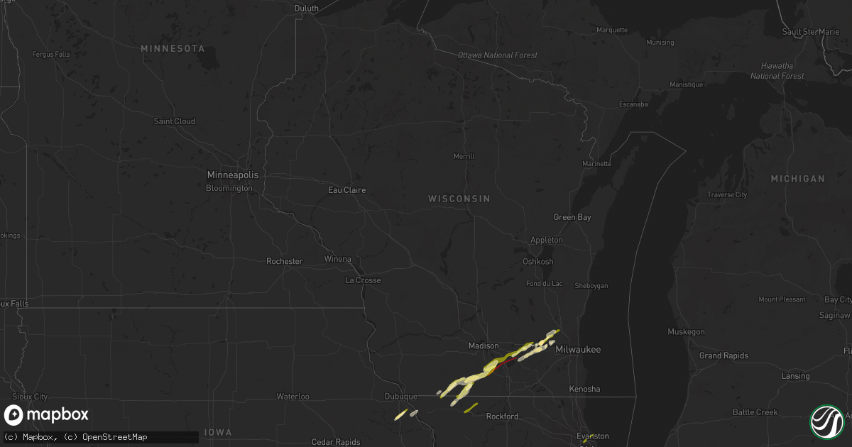
Hail Map in Wisconsin on February 8, 2024
Get this storm
February 8 map
$229
one time, instant access
Download today. No call, no setup
Keep the $229
Bought the map and want the full workflow? Apply the entire $229 to a subscription within 7 days. None of it is wasted.
Every map, not just this one
This buys you this map. Subscription and you get every map we run, in the markets you choose from a few cities to whole states to nationwide. Plus real-time alerts the moment a storm fires.
Contact data
Name, contact info, occupancy, even credit band for addresses in the footprint. You go from where it hit to who to call.
Become the source they trust
Unlimited branding weather history reports on demand. You already have the documented answer ready for the property owner, and you are the one who showed up with it.
Property data and RoofTrace estimates
Pull up any address you have got, its value and the exact code rules for that jurisdiction, straight from One Click Code. Then RoofTrace estimates the squares, pitch, and roof value, priced the way you price.
Storm reports in Wisconsin
Wisconsin
| Date | Description |
|---|---|
| 02/08/20245:46 PM CST | Damage surveys confirm an ef-2 tornado. This tornado touched down southeast of evansville at 5:46 pm cdt and continued on a northeast track to near lake koshkonong... E |
| 02/08/20245:37 PM CST | Reports of tornado on the ground tracking northeast on the north side of albany. |
| 02/08/20245:26 PM CST | A local report indicates 1.00 inch wind near 1 N Monroe |
| 02/08/20245:12 PM CST | Multiple photos of tree limbs down along with a roof removed from a farm outbuilding. Time estimated from radar. |
| 02/08/20245:12 PM CST | Corrects previous tornado report from 1 wnw juda. Damage surveys confirm an ef-1 tornado. This tornado began at approximately 5:12 pm cdt west of juda... Wi and continu |
| 02/07/20247:55 PM CST | Report via social media. Delayed report. |
| 02/07/20247:12 PM CST | Relayed via spotter. Photo of hail next to a quarter. |
| 02/07/20246:56 PM CST | Report from mping. Delayed report. |
| 02/07/20246:50 PM CST | Delayed report via social media. |
| 02/07/20246:49 PM CST | Delayed report. |
| 02/07/20246:48 PM CST | Public photo shared featuring approx. 1 inch hail. |
| 02/07/20246:20 PM CST | Large tree 1 to 2 feet diameter down at intersection of loga rd and st hwy 106. Time estimated by radar. |
| 02/07/20246:09 PM CST | Delayed report via social media. |
| 02/07/20246:00 PM CST | Reports of roof damage and large trees snapped. |
Cities Impacted by Hail Map on February 8, 2024
- Zwingle, IA
- La Motte, IA
- Lacon, IL
- Magnolia, IL
- Warren, IL
- Gratiot, WI
- McNabb, IL
- South Wayne, WI
- Browntown, WI
- Argyle, WI
- Woodford, WI
- Varna, IL
- Sparland, IL
- Lostant, IL
- Winslow, IL
- Orangeville, IL
- Monroe, WI
- Monticello, WI
- Albany, WI
- Evansville, WI
- Brooklyn, WI
- Oregon, WI
- Edgerton, WI
- Stoughton, WI
- Freeport, IL
- Dakota, IL
- Rock City, IL
- Fort Atkinson, WI
- Cambridge, WI
- Jefferson, WI
- Johnson Creek, WI
- Helenville, WI
- Glasford, IL
- Mapleton, IL
- Kingston Mines, IL
- Peoria, IL
- East Peoria, IL
- Creve Coeur, IL
- Washington, IL
- Metamora, IL
- Eureka, IL
- Roanoke, IL
- Lowpoint, IL
- Benson, IL
- Washburn, IL
- Watertown, WI
- Sullivan, WI
- Oconomowoc, WI
- Ixonia, WI
- Okauchee, WI
- Nashotah, WI
- Hartland, WI
- Colgate, WI
- Harwood Heights, IL
- Chicago, IL
- Skokie, IL
- Evanston, IL
- Niles, IL
- Delafield, WI
- Lena, IL
- Sussex, WI
- Pewaukee, WI
- Bellevue, IA
- Hubertus, WI
- Hartford, WI
- Dousman, WI
- Galena, IL
- Whitewater, WI
- McConnell, IL
- Crown Point, IN
- Merrillville, IN
- Richfield, WI
- Channahon, IL
- Minooka, IL
- Shorewood, IL
- Joliet, IL
- Juda, WI
- Brodhead, WI


