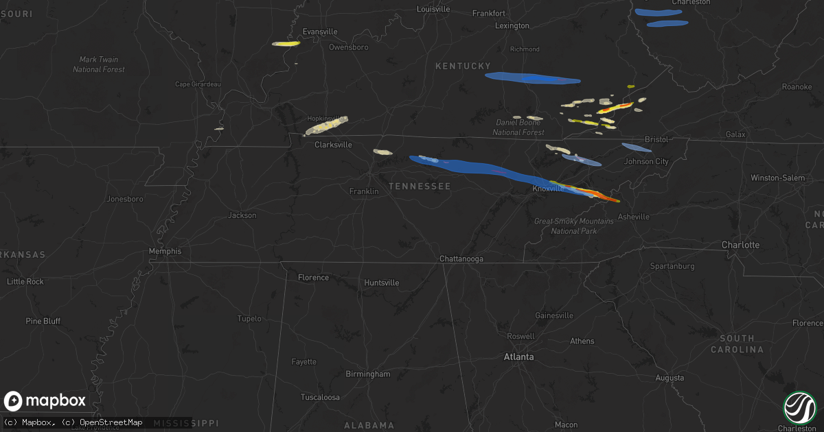
Hail Map in Tennessee on February 6, 2025
Get this storm
February 6 map
$229
one time, instant access
Download today. No call, no setup
Keep the $229
Bought the map and want the full workflow? Apply the entire $229 to a subscription within 7 days. None of it is wasted.
Every map, not just this one
This buys you this map. Subscription and you get every map we run, in the markets you choose from a few cities to whole states to nationwide. Plus real-time alerts the moment a storm fires.
Contact data
Name, contact info, occupancy, even credit band for addresses in the footprint. You go from where it hit to who to call.
Become the source they trust
Unlimited branding weather history reports on demand. You already have the documented answer ready for the property owner, and you are the one who showed up with it.
Property data and RoofTrace estimates
Pull up any address you have got, its value and the exact code rules for that jurisdiction, straight from One Click Code. Then RoofTrace estimates the squares, pitch, and roof value, priced the way you price.
Storm reports in Tennessee
Tennessee
| Date | Description |
|---|---|
| 02/06/20255:38 PM CST | Debris on hwy 80 near pleasant shade... Road passable. |
| 02/05/202510:02 PM CST | A local report indicates 1.00 inch wind near 5 NNW Hartford |
| 02/05/20259:29 PM CST | A few trees down. |
| 02/05/20259:00 PM CST | Social media photo of large hail that caused vehicle damage... Estimated at least golf ball sized and time estimated from radar. |
| 02/05/20258:55 PM CST | Several trees down. |
| 02/05/20258:50 PM CST | Social media photo of a tree that fell on a car in northern kingsport. Time is estimated from radar. |
| 02/05/20258:50 PM CST | Time estimated from radar. |
| 02/05/20258:35 PM CST | Several trees down. |
| 02/05/20258:26 PM CST | The tornado began near mcanally rd and campground rd before moving east along highway 131. There were several barns and outbuildings with roof damage... And numerous sn |
| 02/05/20258:25 PM CST | Several trees down as well. |
| 02/05/20257:47 PM CST | A few trees down. |
| 02/05/20257:25 PM CST | Several homes damaged and trees down. Possible tornado. |
| 02/05/20257:18 PM CST | Several homes damaged and trees down. Reports of fatalities but number unknown. Possible tornado. |
| 02/05/20257:04 PM CST | *** 2 fatal... 2 inj *** tornado may have started in southeast fentress county |
| 02/05/20256:53 PM CST | This tornado touched down northwest of clarkrange along baldwin gulf road in fentress county where it caused roofing damage to a residence. The tornado traveled east-so |
| 02/05/20256:44 PM CST | Multiple power flashes in the crawford community. |
| 02/05/20256:44 PM CST | Multiple power flashes. |
| 02/05/20256:41 PM CST | *** 1 inj *** this tornado touched down near coy phillips road... West of hanging limb in overton county. It then tracked east-southeast into hanging limb where it snap |
| 02/05/20256:38 PM CST | Roof off a house at 202 shadow ln. In rickman. |
| 02/05/20256:38 PM CST | Park rd. In rickman is blocked. Tree... Power line and transformer are down. |
| 02/05/20256:20 PM CST | *** 1 inj *** corrects previous tornado report from 5 nnw algood. This ef1 tornado touched down near cyphers drive in northern putnam county where tree damage was found |
| 02/05/20256:20 PM CST | This ef1 tornado touched down near cyphers drive in northern putnam county where tree damage was found. As the tornado continued east... There was additional tree damag |
| 02/05/20256:20 PM CST | Tree down near house on cindy drive in extreme northern putnam. |
| 02/05/20256:20 PM CST | Several reports of damage of in north cookeville...tree blocking hwy 293...scattered debris...multiple power flashes. |
| 02/05/20256:10 PM CST | The tornado touched down just east of highway 56 north of center grove in jackson county... Where hundreds of trees were snapped and uprooted as well as some minor roof |
All States Impacted by Hail Map on February 6, 2025
Cities Impacted by Hail Map on February 6, 2025
- Brodhead, KY
- Orlando, KY
- Mount Vernon, KY
- Liberty, KY
- Kings Mountain, KY
- Middleburg, KY
- Livingston, KY
- Hustonville, KY
- Crab Orchard, KY
- Waynesburg, KY
- Stanford, KY
- McKee, KY
- East Bernstadt, KY
- Annville, KY
- Tyner, KY
- Booneville, KY
- Vincent, KY
- Manchester, KY
- Sextons Creek, KY
- Oneida, KY
- Ricetown, KY
- Mistletoe, KY
- Jackson, KY
- Buckhorn, KY
- Gays Creek, KY
- East Prairie, MO
- Clinton, KY
- Ridgway, IL
- Junction, IL
- New Haven, IL
- Cadiz, KY
- La Fayette, KY
- Bumpus Mills, TN
- Fort Campbell, KY
- Mount Vernon, IN
- Oak Grove, KY
- Herndon, KY
- Hopkinsville, KY
- Shawneetown, IL
- Pembroke, KY
- Trenton, KY
- Sturgis, KY
- Elkton, KY
- Kettle Island, KY
- Stoney Fork, KY
- Harlan, KY
- Coldiron, KY
- Cumberland, KY
- Cawood, KY
- Coalgood, KY
- Grays Knob, KY
- Cranks, KY
- Kenvir, KY
- Hulen, KY
- Totz, KY
- Lynch, KY
- Partridge, KY
- Eolia, KY
- Appalachia, VA
- Wise, VA
- Pound, VA
- Cottontown, TN
- Hendersonville, TN
- Gallatin, TN
- White House, TN
- Norton, VA
- Greenbrier, TN
- Goodlettsville, TN
- Clintwood, VA
- Coeburn, VA
- McClure, VA
- Clinchco, VA
- Pleasant Shade, TN
- Dixon Springs, TN
- Gainesboro, TN
- Carthage, TN
- Whitleyville, TN
- Granville, TN
- Cookeville, TN
- Mozelle, KY
- Stinnett, KY
- Essie, KY
- Warbranch, KY
- Roark, KY
- Wendover, KY
- Yeaddiss, KY
- Smilax, KY
- Wooton, KY
- Parkers Lake, KY
- Baxter, KY
- Corbin, KY
- Williamsburg, KY
- Rockholds, KY
- Woodbine, KY
- Flat Lick, KY
- Scalf, KY
- Arjay, KY
- Deer Lodge, TN
- Lancing, TN
- Speedwell, TN
- Duff, TN
- New Tazewell, TN
- Bledsoe, KY
- Putney, KY
- Whitesburg, KY
- Linefork, KY
- Hallie, KY
- Cornettsville, KY
- Slemp, KY
- Tazewell, TN
- Saint Charles, VA
- Dryden, VA
- Keokee, VA
- Benham, KY
- Jeremiah, KY
- Premium, KY
- Delphia, KY
- Blackey, KY
- Thorn Hill, TN
- Bean Station, TN
- Kodak, TN
- Strawberry Plains, TN
- Knoxville, TN
- Dandridge, TN
- Sevierville, TN
- Cosby, TN
- Newport, TN
- Hartford, TN
- Del Rio, TN
- Rutledge, TN
- Duffield, VA
- Pennington Gap, VA
- Big Stone Gap, VA
- Holmes Mill, KY
- Closplint, KY
- Wallins Creek, KY
- Jonesville, VA
- Hot Springs, NC
- Marshall, NC
- Alkol, WV
- Griffithsville, WV
- Ranger, WV
- Midkiff, WV
- Spurlockville, WV
- Branchland, WV
- East Lynn, WV
- Wayne, WV
- Fort Gay, WV
- Genoa, WV
- Prichard, WV
- Myra, WV
- Sumerco, WV
- Hamlin, WV
- Yawkey, WV
- Sod, WV
- Alum Creek, WV
- Ridgeview, WV
- Dunlow, WV
- Kiahsville, WV
- Harts, WV
- Danville, WV
- Foster, WV
- Madison, WV
- Seth, WV
- Riddleton, TN
- Hartsville, TN
- Lebanon, TN
- Gordonsville, TN
- Elmwood, TN
- Bloomington Springs, TN
- Livingston, TN
- Monterey, TN
- Rickman, TN
- Wilder, TN
- Crawford, TN
- Grimsley, TN
- Clarkrange, TN
- Crossville, TN
- Jamestown, TN
- Sunbright, TN
- Wartburg, TN
- Briceville, TN
- Oliver Springs, TN
- Oak Ridge, TN
- Clinton, TN
- Powell, TN
- Heiskell, TN
- Jenkins, KY
- Seymour, TN
- Surgoinsville, TN
- Church Hill, TN
- Kingsport, TN
- Mount Carmel, TN
- Rogersville, TN
- Blountville, TN
- Johnson City, TN
- Bluff City, TN
- Piney Flats, TN
- Washburn, TN
- Mooresburg, TN
- Morristown, TN
- Russellville, TN
- Whitesburg, TN
- Bulls Gap, TN


