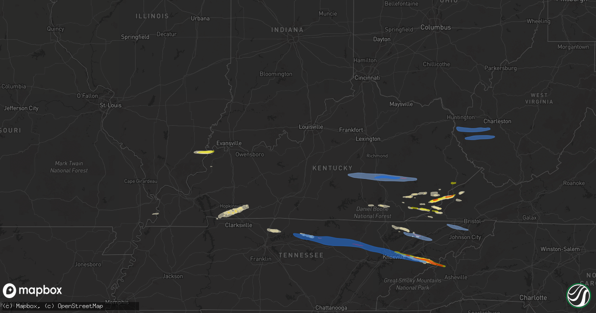
Hail Map in Kentucky on February 6, 2025
Get this storm
February 6 map
$229
one time, instant access
Download today. No call, no setup
Keep the $229
Bought the map and want the full workflow? Apply the entire $229 to a subscription within 7 days. None of it is wasted.
Every map, not just this one
This buys you this map. Subscription and you get every map we run, in the markets you choose from a few cities to whole states to nationwide. Plus real-time alerts the moment a storm fires.
Contact data
Name, contact info, occupancy, even credit band for addresses in the footprint. You go from where it hit to who to call.
Become the source they trust
Unlimited branding weather history reports on demand. You already have the documented answer ready for the property owner, and you are the one who showed up with it.
Property data and RoofTrace estimates
Pull up any address you have got, its value and the exact code rules for that jurisdiction, straight from One Click Code. Then RoofTrace estimates the squares, pitch, and roof value, priced the way you price.
Storm reports in Kentucky
Kentucky
| Date | Description |
|---|---|
| 02/06/20254:42 PM CST | Tree fell on a power line on road 190. |
| 02/06/20254:11 PM CST | Nws morristown relayed a public report of golf ball sized hail in cumberland. Time estimated via radar. |
| 02/06/20254:00 PM CST | Corrects previous tstm wnd dmg report from 1 ssw wasioto. Tree fell on a power line on road 190. Tree fell at intersection of road 190 and beckys branch road. Time was |
| 02/06/20258:40 AM CST | Abandoned trailer home destroyed by thunderstorm winds. Time estimated as approximately the same time as the whitesburg... Ky mesonet reported a 53 mph gust. The mesone |
| 02/06/20258:37 AM CST | Corrects previous report from 2 se wendover. Tree blown down in the 1800 block of camp creek road. |
| 02/06/20257:18 AM CST | Corrects previous tornado report from 1 se island city. The national weather service confirms ef-1 tornado damage near the island city community... On the southwestern |
| 02/06/20257:18 AM CST | Tor possible. Delayed report relayed via broadcast media. Photographs of structural damage and downed trees in between sextons creek and island city. Time estimated via |
| 02/06/20257:18 AM CST | The national weather service confirms ef-1 tornado damage near the island city community... On the southwestern side of owsley county... Via storm survey. Time estimate |
| 02/06/20256:48 AM CST | The national weather service confirms ef-1 tornado damage in the robinet community... On the eastern side of rockcastle county... Via storm survey. Time estimated via r |
| 02/06/20256:48 AM CST | Tor possible. Report of a roof off a house on red hill road in livingston... Ky. Individual contacted the county emergency manager about a possible tornado. Time estima |
| 02/06/20256:46 AM CST | Delayed... Post-survey report. Multiple trees were snapped along big cave road |
| 02/06/20256:12 AM CST | Tree damage in roadway between donansburg and new salem church along donansburg new salem road. |
| 02/05/20257:41 PM CST | A tree was reportedly blown down onto ky-38 near mm 28. Time estimated. |
| 02/05/20257:27 PM CST | Delayed report. Nws storm survey team discovered many tree branches snapped along ky-221 in between 421 and 2009 in nw harlan county. Damage was unidirectional. Time es |
| 02/05/20257:02 PM CST | Quarter sized hail reported at big branch hill off of lick fork of beefhide. Time estimated via radar. |
| 02/05/20256:43 PM CST | Tor possible. Leslie county 911 center reports many tree limbs and other debris scattered around the intersection of 421 and 2058. Time estimated via radar. |
| 02/05/20256:43 PM CST | Updates previous tstm wnd dmg report from 3 nw bledsoe. Leslie county 911 center previously reported many tree limbs downed along 2058 before the intersection with 421. |
| 02/05/20256:35 PM CST | Tree fell over prewitt bend rd... About 1.5 miles off us-25. Time estimated from radar. |
| 02/05/20256:26 PM CST | 3 power poles down along highway 90 east of burkesville... Ky. |
| 02/05/20256:20 PM CST | Multiple trees reported down along us-421 between one stop gas station and stinnett hill road. |
| 02/05/20256:18 PM CST | Updates previous tstm wnd dmg report from 1 e corbin. Report of damage along madison avenue in corbin. Large tree was uprooted and fell on a residence and a vehicle. Tr |
| 02/05/20256:18 PM CST | Delayed report of a row of uprooted trees blown uniformly eastward onto a fence behind a residence on elm street in corbin. |
| 02/05/20256:18 PM CST | Delayed report of a line of trees down behind a residence on john street in corbin. Trees were blown in a uniform direction consistent with other straight line wind dam |
| 02/05/20256:18 PM CST | Report of damage along madison avenue in corbin. Large tree was uprooted and fell on a residence and a vehicle. Time estimated via radar. |
All States Impacted by Hail Map on February 6, 2025
Cities Impacted by Hail Map on February 6, 2025
- Brodhead, KY
- Orlando, KY
- Mount Vernon, KY
- Liberty, KY
- Kings Mountain, KY
- Middleburg, KY
- Livingston, KY
- Hustonville, KY
- Crab Orchard, KY
- Waynesburg, KY
- Stanford, KY
- McKee, KY
- East Bernstadt, KY
- Annville, KY
- Tyner, KY
- Booneville, KY
- Vincent, KY
- Manchester, KY
- Sextons Creek, KY
- Oneida, KY
- Ricetown, KY
- Mistletoe, KY
- Jackson, KY
- Buckhorn, KY
- Gays Creek, KY
- East Prairie, MO
- Clinton, KY
- Ridgway, IL
- Junction, IL
- New Haven, IL
- Cadiz, KY
- La Fayette, KY
- Bumpus Mills, TN
- Fort Campbell, KY
- Mount Vernon, IN
- Oak Grove, KY
- Herndon, KY
- Hopkinsville, KY
- Shawneetown, IL
- Pembroke, KY
- Trenton, KY
- Sturgis, KY
- Elkton, KY
- Kettle Island, KY
- Stoney Fork, KY
- Harlan, KY
- Coldiron, KY
- Cumberland, KY
- Cawood, KY
- Coalgood, KY
- Grays Knob, KY
- Cranks, KY
- Kenvir, KY
- Hulen, KY
- Totz, KY
- Lynch, KY
- Partridge, KY
- Eolia, KY
- Appalachia, VA
- Wise, VA
- Pound, VA
- Cottontown, TN
- Hendersonville, TN
- Gallatin, TN
- White House, TN
- Norton, VA
- Greenbrier, TN
- Goodlettsville, TN
- Clintwood, VA
- Coeburn, VA
- McClure, VA
- Clinchco, VA
- Pleasant Shade, TN
- Dixon Springs, TN
- Gainesboro, TN
- Carthage, TN
- Whitleyville, TN
- Granville, TN
- Cookeville, TN
- Mozelle, KY
- Stinnett, KY
- Essie, KY
- Warbranch, KY
- Roark, KY
- Wendover, KY
- Yeaddiss, KY
- Smilax, KY
- Wooton, KY
- Parkers Lake, KY
- Baxter, KY
- Corbin, KY
- Williamsburg, KY
- Rockholds, KY
- Woodbine, KY
- Flat Lick, KY
- Scalf, KY
- Arjay, KY
- Deer Lodge, TN
- Lancing, TN
- Speedwell, TN
- Duff, TN
- New Tazewell, TN
- Bledsoe, KY
- Putney, KY
- Whitesburg, KY
- Linefork, KY
- Hallie, KY
- Cornettsville, KY
- Slemp, KY
- Tazewell, TN
- Saint Charles, VA
- Dryden, VA
- Keokee, VA
- Benham, KY
- Jeremiah, KY
- Premium, KY
- Delphia, KY
- Blackey, KY
- Thorn Hill, TN
- Bean Station, TN
- Kodak, TN
- Strawberry Plains, TN
- Knoxville, TN
- Dandridge, TN
- Sevierville, TN
- Cosby, TN
- Newport, TN
- Hartford, TN
- Del Rio, TN
- Rutledge, TN
- Duffield, VA
- Pennington Gap, VA
- Big Stone Gap, VA
- Holmes Mill, KY
- Closplint, KY
- Wallins Creek, KY
- Jonesville, VA
- Hot Springs, NC
- Marshall, NC
- Alkol, WV
- Griffithsville, WV
- Ranger, WV
- Midkiff, WV
- Spurlockville, WV
- Branchland, WV
- East Lynn, WV
- Wayne, WV
- Fort Gay, WV
- Genoa, WV
- Prichard, WV
- Myra, WV
- Sumerco, WV
- Hamlin, WV
- Yawkey, WV
- Sod, WV
- Alum Creek, WV
- Ridgeview, WV
- Dunlow, WV
- Kiahsville, WV
- Harts, WV
- Danville, WV
- Foster, WV
- Madison, WV
- Seth, WV
- Riddleton, TN
- Hartsville, TN
- Lebanon, TN
- Gordonsville, TN
- Elmwood, TN
- Bloomington Springs, TN
- Livingston, TN
- Monterey, TN
- Rickman, TN
- Wilder, TN
- Crawford, TN
- Grimsley, TN
- Clarkrange, TN
- Crossville, TN
- Jamestown, TN
- Sunbright, TN
- Wartburg, TN
- Briceville, TN
- Oliver Springs, TN
- Oak Ridge, TN
- Clinton, TN
- Powell, TN
- Heiskell, TN
- Jenkins, KY
- Seymour, TN
- Surgoinsville, TN
- Church Hill, TN
- Kingsport, TN
- Mount Carmel, TN
- Rogersville, TN
- Blountville, TN
- Johnson City, TN
- Bluff City, TN
- Piney Flats, TN
- Washburn, TN
- Mooresburg, TN
- Morristown, TN
- Russellville, TN
- Whitesburg, TN
- Bulls Gap, TN


