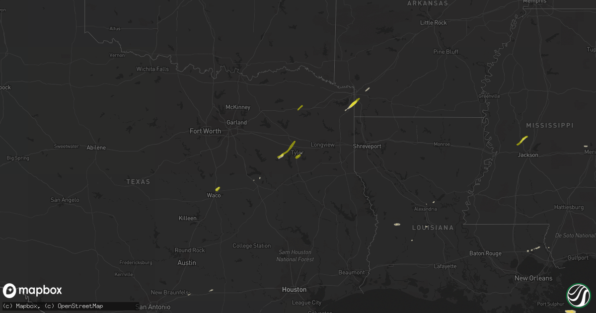
Hail Map on February 6, 2018
Get this storm
February 6 map
$229
one time, instant access
Download today. No call, no setup
Keep the $229
Bought the map and want the full workflow? Apply the entire $229 to a subscription within 7 days. None of it is wasted.
Every map, not just this one
This buys you this map. Subscription and you get every map we run, in the markets you choose from a few cities to whole states to nationwide. Plus real-time alerts the moment a storm fires.
Contact data
Name, contact info, occupancy, even credit band for addresses in the footprint. You go from where it hit to who to call.
Become the source they trust
Unlimited branding weather history reports on demand. You already have the documented answer ready for the property owner, and you are the one who showed up with it.
Property data and RoofTrace estimates
Pull up any address you have got, its value and the exact code rules for that jurisdiction, straight from One Click Code. Then RoofTrace estimates the squares, pitch, and roof value, priced the way you price.
Storm reports
Arkansas
| Date | Description |
|---|---|
| 02/06/20183:42 PM CST | Quarter size hail reported on i-49 reported asp troopers. |
| 02/05/201810:06 PM CST | At 406 PM CST, a severe thunderstorm was located 8 miles southwest of Hope, moving northeast at 45 mph. HAZARD...Half dollar size hail. SOURCE...Radar indicated. IMPACT...Damage to vehicles is expected. Locations impacted include... Hope, Prescott, Emmet, Perrytown, Patmos, Sutton, Laneburg and Boughton. |
Alabama
| Date | Description |
|---|---|
| 02/06/20185:57 AM CST | Nws meteorologists surveyed damage near the hale and marengo county line and determined that the damage was consistent with an ef0 tornado. This tornado began in mareng |
| 02/06/20185:53 AM CST | Trees down near highway 139 and shady grove rd via facebook. |
| 02/06/20185:51 AM CST | Nws meteorologists surveyed damage in southeast bibb county and determined that the damage was consistent with an ef0 tornado. A tornado touched down just to the west o |
| 02/06/20185:45 AM CST | Damage to a barn and a mobile home along with some timber damage from photos submitted by a tv station viewer. Location approximate. Time estimated by radar. |
| 02/06/20185:44 AM CST | Nws meteorologists surveyed damage in far northern marengo county and determined that the damage was consistent with an ef1 tornado. The tornado began near the intersec |
| 02/06/20185:11 AM CST | Nws meteorologists surveyed damage in southern sumter county and determined that the damage was consistent with an ef0 tornado. The tornado started on the east side of |
| 02/06/20185:08 AM CST | Shingles reported off of a home and report of a store that lost its roof. Location and time estimated by radar. |
| 02/06/20185:06 AM CST | Roof blown off of service station near the intersection of u.s. Highway 80 and alabama highway 17 in the siloam community. Portions of the awning and roof to the bbq pi |
Louisiana
| Date | Description |
|---|---|
| 02/06/20183:48 AM CST | Tornado started west of webster marcile road near the community of cravens snapping several pine trees along the path. It crossed highway 10 north of pitkin then travel |
Mississippi
| Date | Description |
|---|---|
| 02/06/20185:37 AM CST | At 1137 PM CST, a severe thunderstorm was located over Flora, or 14 miles northwest of Madison, moving northeast at 50 mph. HAZARD...60 mph wind gusts and half dollar size hail. SOURCE...Radar indicated. IMPACT...Hail damage to vehicles is expected. Expect wind damage to roofs, siding, and trees. This severe thunderstorm will be near... Myrleville around 1150 PM CST. Way around 1205 AM CST. Other locations impacted by this severe thunderstorm includeBentonia. |
| 02/06/20184:36 AM CST | Roof damage to a restaurant. |
| 02/06/20184:25 AM CST | Trees and power lines down. |
| 02/06/20184:20 AM CST | Em reports tree down on a house cedar street in suqualena area. |
| 02/06/20184:15 AM CST | Nws storm survey team found damage consistent with an ef-1 tornado. This tornado was on the ground for 7.97 miles with peak winds of 110 mph and max width of 240 yards. |
| 02/06/20181:55 AM CST | Tree fell on a home along brooksville rd near truman weeks rd. |
| 02/06/20181:36 AM CST | Tree down at intersection of center road and highway 19...reported by attala so. |
| 02/06/20181:35 AM CST | A tree fell on and destroyed a pickup truck...reported by attala so. |
| 02/06/20181:05 AM CST | Reports of trees down on truitt rd in madison county. |
Texas
| Date | Description |
|---|---|
| 02/06/20184:25 PM CST | Reported by ham radio operator. |
| 02/06/20183:24 PM CST | International paper plant reported half dollar-sized hail. |
| 02/06/20183:05 PM CST | A local report indicates 1.50 inch wind near MOUNT VERNON |
| 02/06/20183:05 PM CST | Mt vernon herold newspaper reports hail pea to quarter size covering the ground in downtown mount vernon area. |
| 02/05/201810:14 PM CST | At 414 PM CST, a severe thunderstorm was located near Edom, or 13 miles northwest of Tyler, moving northeast at 45 mph. HAZARD...Half dollar size hail. SOURCE...Radar indicated. IMPACT...Damage to vehicles is expected. Locations impacted include... Lindale, Hawkins, Hoard, Red Springs and Carroll. |
| 02/05/20189:22 PM CST | At 322 PM CST, a severe thunderstorm was located 7 miles northeast of Queen City, or 10 miles northeast of Atlanta, moving northeast at 45 mph. HAZARD...Quarter size hail. SOURCE...Radar indicated. IMPACT...Damage to vehicles is expected. Locations impacted include... Texarkana, Fouke, Garland, Genoa, Domino, Ferguson, Pleasant Hill and Hervey. |
| 02/05/20188:30 PM CST | At 230 PM CST, a severe thunderstorm was located near Northcrest, or near Lacy-Lakeview, moving northeast at 45 mph. HAZARD...Quarter size hail. SOURCE...Radar indicated. IMPACT...Damage to vehicles is possible. Locations impacted include... Bellmead, Lacy-Lakeview, Hubbard, Hallsburg, Northcrest, Leroy, Mount Calm, Ross and Penelope.This includes Interstate 35 between mile markers 337 and 347. |
Cities Impacted by Hail Map on February 6, 2018
- Pitkin, LA
- Covington, TN
- Tyler, TX
- Collinsville, MS
- Chunky, MS
- Little Rock, MS
- Pineville, LA
- Flora, MS
- Texarkana, AR
- Fulton, AR
- Hope, AR
- Picayune, MS
- Queen City, TX
- Covington, LA
- Abita Springs, LA
- Canton, MS
- Gallion, AL
- Greensboro, AL
- Waco, TX
- Elm Mott, TX
- Murchison, TX
- Brownsboro, TX
- Athens, TX
- Atlanta, TX
- Forkland, AL
- Mount Vernon, TX
- Flatonia, TX
- Waelder, TX
- Livingston, AL
- Fairfield, TX
- York, AL
- Birmingham, AL
- Helena, AL
- Boligee, AL
- Cuba, AL
- Bellamy, AL
- Ward, AL
- Luling, TX
- Oberlin, LA
- Camden, AR
- Louann, AR
- Bolton, MS
- Whitehouse, TX
- Flint, TX
- Axtell, TX
- Fouke, AR
- Ben Wheeler, TX
- Chandler, TX
- Lindale, TX