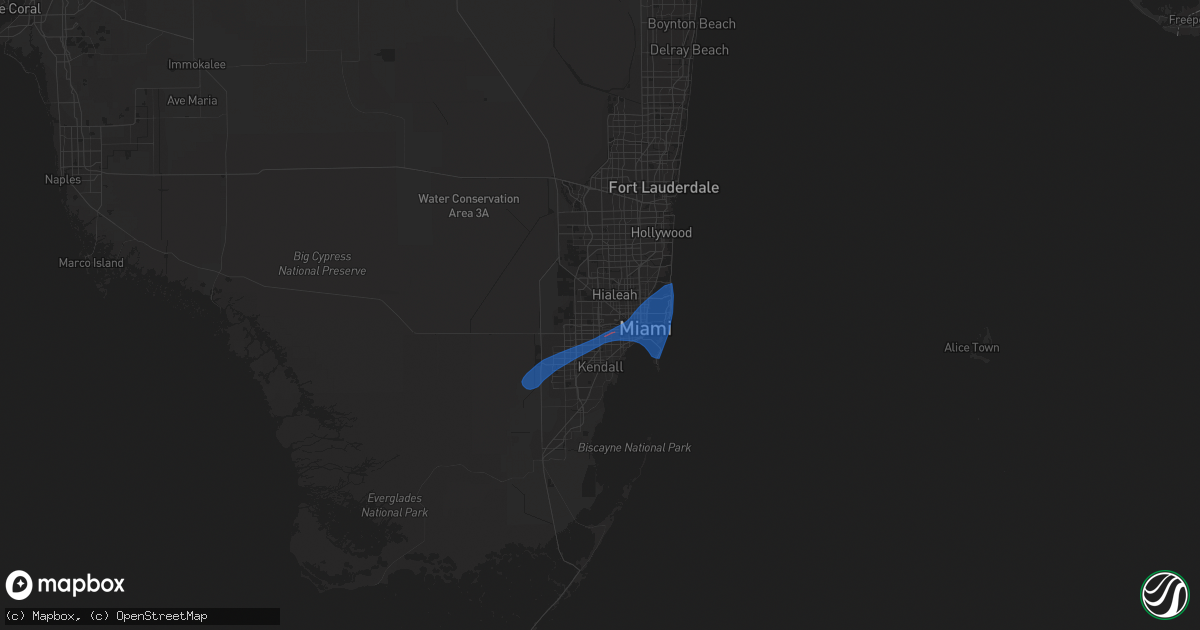
Hail Map in Miami, FL on February 4, 2024
Get this storm
February 4 map
$229
one time, instant access
Download today. No call, no setup
Keep the $229
Bought the map and want the full workflow? Apply the entire $229 to a subscription within 7 days. None of it is wasted.
Every map, not just this one
This buys you this map. Subscription and you get every map we run, in the markets you choose from a few cities to whole states to nationwide. Plus real-time alerts the moment a storm fires.
Contact data
Name, contact info, occupancy, even credit band for addresses in the footprint. You go from where it hit to who to call.
Become the source they trust
Unlimited branding weather history reports on demand. You already have the documented answer ready for the property owner, and you are the one who showed up with it.
Property data and RoofTrace estimates
Pull up any address you have got, its value and the exact code rules for that jurisdiction, straight from One Click Code. Then RoofTrace estimates the squares, pitch, and roof value, priced the way you price.
Storm reports in Miami, FL
Miami, FL
| Date | Description |
|---|---|
| 02/04/202410:20 AM CST | University of miami health system mesonet site reported a 67 mph wind gust at 1120 am with a line of severe thunderstorms moving through the area. |
| 02/04/202410:07 AM CST | Nws storm survey found a swath of straight-line wind damage that began with the overturned semi-tractor trailer on krome ave/sw 104th st and cut through several areas o |
| 02/04/20249:53 AM CST | Miami dade police/fire rescue reported that miami-dade transit called in a report of a downed tree blocking the roadway causing traffic disruptions. It has since been c |
| 02/04/20249:52 AM CST | Nws storm survey found a few snapped trees near sw 88th street and sw 157th avenue. All the trees were damaged in the same direction with no signs of rotation detected. |
| 02/04/20249:51 AM CST | Florida highway patrol dispatch reported an empty semi-truck that was blown over |
| 02/04/20249:47 AM CST | Florida highway patrol reported that strong winds blew a semi-tractor trailer onto another vehicle on krome avenue south of sw 104 street. Time estimated from radar. |
All Cities Impacted by Hail Map on February 4, 2024
- Summerland Key, FL
- Miami, FL
- Miami Beach, FL
- Key Biscayne, FL
- Goodell, IA
- Buffalo Center, IA
- Woden, IA
- Forest City, IA
- Britt, IA
- Lime Springs, IA
- Elma, IA
- Grafton, IA
- Kensett, IA
- Iowa Falls, IA
- Belmond, IA
- Stacyville, IA
- McIntire, IA
- Hampton, IA
- Ackley, IA
- Riceville, IA
- Chester, IA
- Latimer, IA
- Alexander, IA
- Saint Ansgar, IA
- Bradford, IA
- Geneva, IA
- Alden, IA
- Garner, IA
- Kanawha, IA
- Dows, IA
- Dexter, MN
- Lamont, FL
- Monticello, FL
- Alachua, FL
- Lake Butler, FL
- Jasper, FL
- White Springs, FL
- Sanderson, FL
- Lake City, FL
- Glen Saint Mary, FL
- Macclenny, FL
- Valdosta, GA
- Homerville, GA
- Jacksonville, FL
- Saint George, GA
- Middleburg, FL
- Bryceville, FL
- Callahan, FL
- Homosassa, FL
- Gainesville, FL
- Palm Coast, FL
- Flagler Beach, FL
- Bunnell, FL
- Tickfaw, LA
- Independence, LA
- Hammond, LA
- Yalaha, FL
- Tavares, FL
- Astatula, FL
- Ocoee, FL
- Winter Garden, FL
- Windermere, FL
- Gotha, FL
- Orlando, FL
- Winter Park, FL
- Oviedo, FL
- Umatilla, FL
- Saint Cloud, FL
- Poplarville, MS
- Ormond Beach, FL
- Ocala, FL
- Ocklawaha, FL
- Seville, FL
- Pierson, FL
- Howey In The Hills, FL
- Leesburg, FL
- Melbourne, FL
- Monterey, LA
- Jonesville, LA
- Clermont, FL
- Okahumpka, FL
- Christmas, FL
- Amite, LA
- Perkinston, MS
- Mount Dora, FL
- Eustis, FL
- Altoona, FL
- Saint Landry, LA
- Holden, LA
- Lecanto, FL
- Boston, GA


