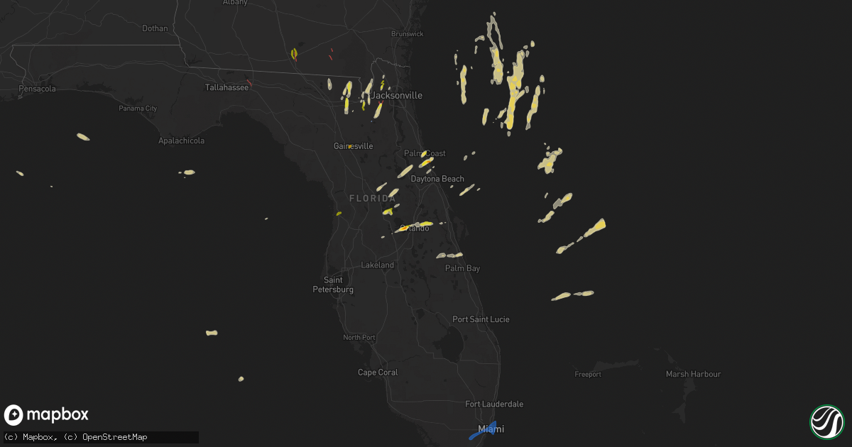
Hail Map on February 4, 2024
Get this storm
February 4 map
$229
one time, instant access
Download today. No call, no setup
Keep the $229
Bought the map and want the full workflow? Apply the entire $229 to a subscription within 7 days. None of it is wasted.
Every map, not just this one
This buys you this map. Subscription and you get every map we run, in the markets you choose from a few cities to whole states to nationwide. Plus real-time alerts the moment a storm fires.
Contact data
Name, contact info, occupancy, even credit band for addresses in the footprint. You go from where it hit to who to call.
Become the source they trust
Unlimited branding weather history reports on demand. You already have the documented answer ready for the property owner, and you are the one who showed up with it.
Property data and RoofTrace estimates
Pull up any address you have got, its value and the exact code rules for that jurisdiction, straight from One Click Code. Then RoofTrace estimates the squares, pitch, and roof value, priced the way you price.
Storm reports
Florida
| Date | Description |
|---|---|
| 02/04/20245:50 PM CST | Quarter sized hail reported to the north of palm coast parkway ne in palm coast... Fl. |
| 02/04/20245:12 PM CST | Public report of half dollar sized hail near ratliff fl... In nassau county. |
| 02/04/20244:20 PM CST | Corrects previous hail report from homosassa. Pictures shows hail was around 1.25 inch. |
| 02/04/20243:13 PM CST | Multiple trees down along cr-225. Possible tornado damage. |
| 02/04/20243:12 PM CST | Video of tornado touching down near cecil field from the public... And em reports damage to homes in the area. Video was taken near argyle forest blvd and fl23 looking |
| 02/04/20242:10 PM CST | 1 inch hail reported with passing storm. |
| 02/04/20241:56 PM CST | Photo from social media showing estimated quarter sized hail littering the green at uf golf course in gainesville... Fl. Time estimated off radar. |
| 02/04/202412:33 PM CST | Photo of a tree down along i-10 with a tds just north of the interstate. Possible tornado. |
| 02/04/202410:20 AM CST | University of miami health system mesonet site reported a 67 mph wind gust at 1120 am with a line of severe thunderstorms moving through the area. |
| 02/04/202410:07 AM CST | Nws storm survey found a swath of straight-line wind damage that began with the overturned semi-tractor trailer on krome ave/sw 104th st and cut through several areas o |
| 02/04/20249:53 AM CST | Miami dade police/fire rescue reported that miami-dade transit called in a report of a downed tree blocking the roadway causing traffic disruptions. It has since been c |
| 02/04/20249:52 AM CST | Nws storm survey found a few snapped trees near sw 88th street and sw 157th avenue. All the trees were damaged in the same direction with no signs of rotation detected. |
| 02/04/20249:51 AM CST | Florida highway patrol dispatch reported an empty semi-truck that was blown over |
| 02/04/20249:47 AM CST | Florida highway patrol reported that strong winds blew a semi-tractor trailer onto another vehicle on krome avenue south of sw 104 street. Time estimated from radar. |
| 02/03/20247:10 PM CST | Public reports quarter size hail near east lake elementary school... Northeast of ucf. |
| 02/03/20246:24 PM CST | Quarter sized... 1 inch diameter... Hail reported in ocoee near the intersection of good homes rd. And sr-50. |
| 02/03/20246:24 PM CST | Quarter sized... 1 inch diameter... Hail reported in ocoee near the intersection of white and clarke rd. |
| 02/03/20246:21 PM CST | [delayed report] public reports hail to ping ball size in gotha on social media. |
| 02/03/20246:06 PM CST | Ping pong sized hail reported at bulow plantation... West of flagler beach. |
| 02/03/20246:00 PM CST | Quarter sized... 1 inch diameter... Hail reported at the seaplane base in tavares. |
Idaho
| Date | Description |
|---|---|
| 02/04/202412:03 AM CST | 1-inch tree limbs broken; shingles blown off. |
California
| Date | Description |
|---|---|
| 02/04/20245:43 PM CST | Trees uprooted or snapped; roof blown off. |
| 02/04/20245:14 PM CST | 3-inch tree limbs broken; power poles broken. |
| 02/04/20244:54 PM CST | 1-inch tree limbs broken; shingles blown off. |
| 02/04/20243:11 PM CST | 1-inch tree limbs broken; shingles blown off. |
| 02/04/20243:10 PM CST | 1-inch tree limbs broken; shingles blown off. |
| 02/04/202411:14 AM CST | 1-inch tree limbs broken; shingles blown off. |
| 02/04/202411:10 AM CST | Tree across the roadway. |
| 02/04/202410:57 AM CST | Tree down. |
| 02/04/202410:23 AM CST | Very large tree blocking both lanes on orr springs road. |
| 02/04/20249:30 AM CST | Power lines in trees. |
| 02/03/20247:11 PM CST | 1-inch tree limbs broken; shingles blown off. |
| 02/03/20247:09 PM CST | 3-inch tree limbs broken; power poles broken. |
| 02/03/20246:12 PM CST | 3-inch tree limbs broken; power poles broken. |
Louisiana
| Date | Description |
|---|---|
| 02/04/20245:44 PM CST | Picture of hail estimated to quarter-sized from social media near independence. Time and location estimated from radar. |
| 02/03/20246:13 PM CST | Picture via social media of nickel to quarter sized hail in hammond. |
| 02/03/20246:07 PM CST | Viewer photo relayed via broadcast media of large hail in the north side of hammond... Estimated to be around 1.75 inches in diameter. Time estimated from radar. |
| 02/03/20246:02 PM CST | Broadcast media photo of ping-pong ball to golf ball sized hail in tickfaw. Time estimated from radar. |
Georgia
| Date | Description |
|---|---|
| 02/04/20242:53 PM CST | Clinch em paramedic reported damage along 447 salt road in homerville ga. Possible tornado. Time estimated off radar. |
| 02/04/20242:47 PM CST | Spotter reported trees and power lines down along bethel church rd in homerville... Ga. Possible tornado. Time estimated off radar. |
| 02/04/20242:13 PM CST | Quarter size hail reported off bemiss road. |
| 02/04/20242:10 PM CST | Numerous photos and video of a tornado with damage reported in the area. |
Cities Impacted by Hail Map on February 4, 2024
- Summerland Key, FL
- Miami, FL
- Miami Beach, FL
- Key Biscayne, FL
- Goodell, IA
- Buffalo Center, IA
- Woden, IA
- Forest City, IA
- Britt, IA
- Lime Springs, IA
- Elma, IA
- Grafton, IA
- Kensett, IA
- Iowa Falls, IA
- Belmond, IA
- Stacyville, IA
- McIntire, IA
- Hampton, IA
- Ackley, IA
- Riceville, IA
- Chester, IA
- Latimer, IA
- Alexander, IA
- Saint Ansgar, IA
- Bradford, IA
- Geneva, IA
- Alden, IA
- Garner, IA
- Kanawha, IA
- Dows, IA
- Dexter, MN
- Lamont, FL
- Monticello, FL
- Alachua, FL
- Lake Butler, FL
- Jasper, FL
- White Springs, FL
- Sanderson, FL
- Lake City, FL
- Glen Saint Mary, FL
- Macclenny, FL
- Valdosta, GA
- Homerville, GA
- Jacksonville, FL
- Saint George, GA
- Middleburg, FL
- Bryceville, FL
- Callahan, FL
- Homosassa, FL
- Gainesville, FL
- Palm Coast, FL
- Flagler Beach, FL
- Bunnell, FL
- Tickfaw, LA
- Independence, LA
- Hammond, LA
- Yalaha, FL
- Tavares, FL
- Astatula, FL
- Ocoee, FL
- Winter Garden, FL
- Windermere, FL
- Gotha, FL
- Orlando, FL
- Winter Park, FL
- Oviedo, FL
- Umatilla, FL
- Saint Cloud, FL
- Poplarville, MS
- Ormond Beach, FL
- Ocala, FL
- Ocklawaha, FL
- Seville, FL
- Pierson, FL
- Howey In The Hills, FL
- Leesburg, FL
- Melbourne, FL
- Monterey, LA
- Jonesville, LA
- Clermont, FL
- Okahumpka, FL
- Christmas, FL
- Amite, LA
- Perkinston, MS
- Mount Dora, FL
- Eustis, FL
- Altoona, FL
- Saint Landry, LA
- Holden, LA
- Lecanto, FL
- Boston, GA