Hail Map in Mississippi on February 1, 2012
Get this storm
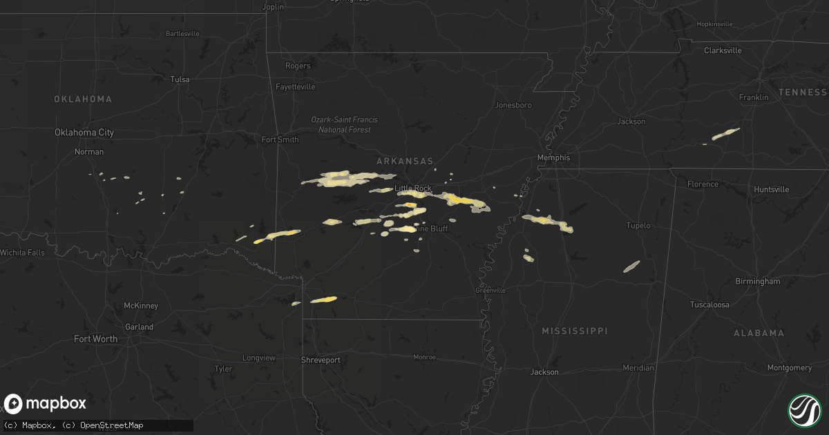
February 1 map
$229
one time, instant access
Download today. No call, no setup
Keep the $229
Bought the map and want the full workflow? Apply the entire $229 to a subscription within 7 days. None of it is wasted.
Every map, not just this one
This buys you this map. Subscription and you get every map we run, in the markets you choose from a few cities to whole states to nationwide. Plus real-time alerts the moment a storm fires.
Contact data
Name, contact info, occupancy, even credit band for addresses in the footprint. You go from where it hit to who to call.
Become the source they trust
Unlimited branding weather history reports on demand. You already have the documented answer ready for the property owner, and you are the one who showed up with it.
Property data and RoofTrace estimates
Pull up any address you have got, its value and the exact code rules for that jurisdiction, straight from One Click Code. Then RoofTrace estimates the squares, pitch, and roof value, priced the way you price.
Storm reports in Mississippi
Mississippi
| Date | Description |
|---|---|
| 02/01/20125:58 PM CST | A few trees were blown down around the holcomb area. |
| 02/01/20125:57 PM CST | Trees downed along ms highway 7 near the grenada county line. |
| 02/01/20125:44 PM CST | A local report indicates 1.00 inch wind near 1 N COURTLAND |
| 02/01/20125:35 PM CST | A local report indicates 1.00 inch wind near 1 S BATESVILLE |
| 02/01/20125:35 PM CST | A few power lines and power poles down between minter city and schlater. |
| 02/01/20125:31 PM CST | A local report indicates 1.00 inch wind near CURTIS STATION |
| 02/01/20125:20 PM CST | Trees down in dundee. |
| 02/01/20125:16 PM CST | 3 homes with roof dmg and a outbuilding was blown away along drew-merigold rd and jennings rd. |
| 02/01/20125:05 PM CST | Large trees down...reported by bolivar eoc |
| 02/01/20125:05 PM CST | Trees down in a mobile home park. |
| 02/01/20125:00 PM CST | Tree down on reno street. |
| 02/01/20124:50 PM CST | A utility pole was downed along hwy 1 north of rosedale |
| 02/01/20124:44 PM CST | A shed was destroyed. Trees were also down. |
| 01/31/20128:12 PM CST | Damage to a mobile home and damage to outdoor storage buildings on sipsey-detroit road a mile and a half west of the alabama state border. |
| 01/31/20128:05 PM CST | Power lines down between athens and quincy. |
| 01/31/20127:55 PM CST | Several trees down across highway 25 south of becker |
| 01/31/20127:46 PM CST | Awning over the gas pumps damaged and blown off from gas station along hwy 145 north in aberdeen. |
| 01/31/20127:10 PM CST | Several trees down along highway 345 from 1 mile south of cherry creek north to include cherry creek. |
| 01/31/20127:09 PM CST | A few trees were blown down across ne webster co. |
| 01/31/20126:50 PM CST | A few trees were blown down. |
| 01/31/20126:30 PM CST | Powerlines down from large tree on county road 158. |
| 01/31/20126:22 PM CST | Powerlines down from a 6-18 inch diameter tree. |
| 01/31/20126:10 PM CST | *** 1 fatal *** one fatality occurred when a pine tree fell on a atv/operator. This occurred along co rd 286...between co rds 93 and 95. |
| 01/31/20126:05 PM CST | Trees downed along cr 106 near the grenada county line |
| 01/31/20126:03 PM CST | A tree down across kay lane. |
All States Impacted by Hail Map on February 1, 2012
Cities Impacted by Hail Map on February 1, 2012
- Danville, AR
- Rover, AR
- Plainview, AR
- Fouke, AR
- Stamps, AR
- Lewisville, AR
- Garland City, AR
- Broken Bow, OK
- Mantee, MS
- Prairie, MS
- Pheba, MS
- Maben, MS
- West Point, MS
- Cedarbluff, MS
- Benton, AR
- Alexander, AR
- Paron, AR
- De Queen, AR
- Lawrenceburg, TN
- Courtland, MS
- Pope, MS
- Batesville, MS
- Water Valley, MS
- Grapevine, AR
- Leola, AR
- Eagletown, OK
- Gillham, AR
- Drew, MS
- Minter City, MS
- Amity, AR
- Glenwood, AR
- Humphrey, AR
- Wayne, OK
- Charleston, MS
- Holly Grove, AR
- Casscoe, AR
- Carlisle, AR
- Crocketts Bluff, AR
- Hazen, AR
- Roe, AR
- Almyra, AR
- Humnoke, AR
- De Witt, AR
- Stuttgart, AR
- Ulm, AR
- England, AR
- Lonoke, AR
- Clarendon, AR
- White Hall, AR
- Pine Bluff, AR
- Sheridan, AR
- Perryville, AR
- Hensley, AR
- Redfield, AR
- Bluffton, AR
- Briggsville, AR
- Harrodsburg, KY
- Greenwood, MS
- Donaldson, AR
- Bismarck, AR
- Sledge, MS
- Marks, MS
- Coahoma, MS
- Crenshaw, MS
- Little Rock, AR
- Harvey, AR
- Gravelly, AR
- Stonewall, OK
- Ola, AR
- Malvern, AR
- Kiowa, OK
- Hot Springs Village, AR
- Lonsdale, AR
- Mabelvale, AR
- Jefferson, AR
- Tucker, AR
- Rison, AR
- Byars, OK
- Ada, OK
- Summertown, TN
- Mount Pleasant, TN
- Poyen, AR
- Scott, AR
- Pauls Valley, OK
- Traskwood, AR
- Arkadelphia, AR
- Carthage, AR
- Austin, AR
- Ward, AR
- Willisburg, KY
- Wright City, OK
- Valliant, OK
- Kirby, AR
- Bauxite, AR
- Columbia, TN
- De Valls Bluff, AR
- Tunica, MS
- Atlanta, TX
- Queen City, TX
- Moro, AR
- Prattsville, AR
- Boles, AR
- Waldron, AR
- Parks, AR
- Bryant, AR
- Sulphur, OK
- Coalgate, OK
- Roland, AR
- Bigelow, AR
- Marianna, AR
- Dierks, AR
- Stuart, OK
- Mcalester, OK
- Tutwiler, MS
- Waynesboro, TN
- Roff, OK


