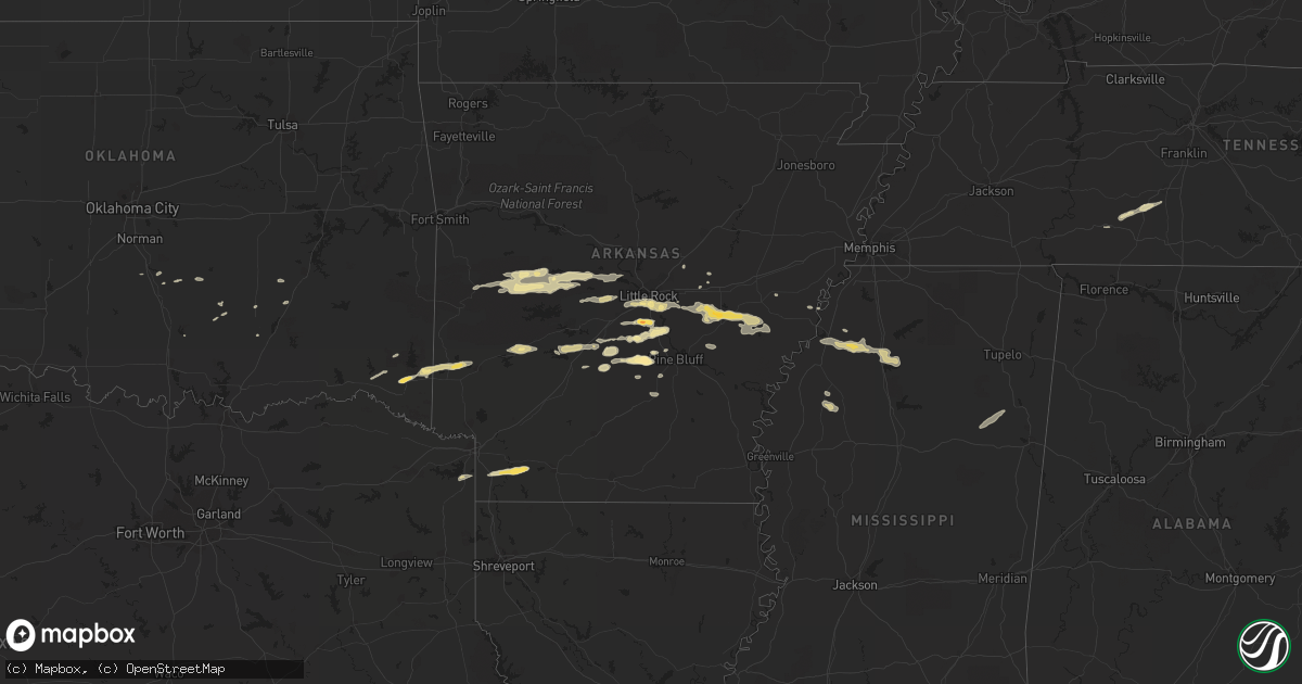
Hail Map in Arkansas on February 1, 2012
Get this storm
February 1 map
$229
one time, instant access
Download today. No call, no setup
Keep the $229
Bought the map and want the full workflow? Apply the entire $229 to a subscription within 7 days. None of it is wasted.
Every map, not just this one
This buys you this map. Subscription and you get every map we run, in the markets you choose from a few cities to whole states to nationwide. Plus real-time alerts the moment a storm fires.
Contact data
Name, contact info, occupancy, even credit band for addresses in the footprint. You go from where it hit to who to call.
Become the source they trust
Unlimited branding weather history reports on demand. You already have the documented answer ready for the property owner, and you are the one who showed up with it.
Property data and RoofTrace estimates
Pull up any address you have got, its value and the exact code rules for that jurisdiction, straight from One Click Code. Then RoofTrace estimates the squares, pitch, and roof value, priced the way you price.
Storm reports in Arkansas
Arkansas
| Date | Description |
|---|---|
| 02/01/20124:39 PM CST | State police reported 70-75 mph wind gusts across central phillips county. |
| 02/01/20124:37 PM CST | A tree was downed along hwy 1 in watson. |
| 02/01/20124:14 PM CST | Several trees and powerlines were downed south of de witt. |
| 02/01/20124:14 PM CST | A couple of trees were downed in the de witt area. |
| 02/01/20123:41 PM CST | Smackover police department reported quarter-sized hail on west side of the city of smackover. |
| 02/01/20123:40 PM CST | Several trees are down in pine bluff on 5th and cherry. A few powerlines are also down. |
| 02/01/20123:40 PM CST | Several trees and powerlines are down on highway 79 between stuttgart and ulm. |
| 02/01/20123:38 PM CST | Measured at the stuttgart airport. |
| 02/01/20123:38 PM CST | A local report indicates 1.50 inch wind near 3 S SLOVAK |
| 02/01/20123:38 PM CST | Minor damage was reported to three hangers at the stuttgart municipal airport. Power lines are also down along hwy 79 between stuttgart and roe. |
| 02/01/20123:30 PM CST | Several trees were blown down along 46 south. |
| 02/01/20123:30 PM CST | Several trees are down in the humnoke area. |
| 02/01/20123:19 PM CST | A local report indicates 1.75 inch wind near AIN |
| 02/01/20123:17 PM CST | Hail of different sizes falling...mostly marble with larger mixed in. |
| 02/01/20123:01 PM CST | A local report indicates 1.00 inch wind near REDFIELD |
| 02/01/20122:54 PM CST | A local report indicates 1.00 inch wind near 2 SE MALVERN |
| 02/01/20122:50 PM CST | Trees and powerlines are down in malvern. |
| 02/01/20122:45 PM CST | A local report indicates 1.75 inch wind near EAST END |
| 02/01/20122:43 PM CST | Broadcast media received a report from a traveler in lafayette county that encountered golf ball-sized hail...and could have possibly been bigger. |
| 02/01/20122:41 PM CST | A local report indicates 1.00 inch wind near EAST END |
| 02/01/20122:24 PM CST | Trees and powerlines are down in bismark. |
| 02/01/20122:14 PM CST | Hail ranging from dime sized to quarter sized are currently falling. |
| 02/01/20122:10 PM CST | Hail between the size of dimes and quarters are covering the ground on highway 9 between crows and paron. |
| 02/01/20121:06 PM CST | A local report indicates 1.00 inch wind near ROVER |
All States Impacted by Hail Map on February 1, 2012
Cities Impacted by Hail Map on February 1, 2012
- Danville, AR
- Rover, AR
- Plainview, AR
- Fouke, AR
- Stamps, AR
- Lewisville, AR
- Garland City, AR
- Broken Bow, OK
- Mantee, MS
- Prairie, MS
- Pheba, MS
- Maben, MS
- West Point, MS
- Cedarbluff, MS
- Benton, AR
- Alexander, AR
- Paron, AR
- De Queen, AR
- Lawrenceburg, TN
- Courtland, MS
- Pope, MS
- Batesville, MS
- Water Valley, MS
- Grapevine, AR
- Leola, AR
- Eagletown, OK
- Gillham, AR
- Drew, MS
- Minter City, MS
- Amity, AR
- Glenwood, AR
- Humphrey, AR
- Wayne, OK
- Charleston, MS
- Holly Grove, AR
- Casscoe, AR
- Carlisle, AR
- Crocketts Bluff, AR
- Hazen, AR
- Roe, AR
- Almyra, AR
- Humnoke, AR
- De Witt, AR
- Stuttgart, AR
- Ulm, AR
- England, AR
- Lonoke, AR
- Clarendon, AR
- White Hall, AR
- Pine Bluff, AR
- Sheridan, AR
- Perryville, AR
- Hensley, AR
- Redfield, AR
- Bluffton, AR
- Briggsville, AR
- Harrodsburg, KY
- Greenwood, MS
- Donaldson, AR
- Bismarck, AR
- Sledge, MS
- Marks, MS
- Coahoma, MS
- Crenshaw, MS
- Little Rock, AR
- Harvey, AR
- Gravelly, AR
- Stonewall, OK
- Ola, AR
- Malvern, AR
- Kiowa, OK
- Hot Springs Village, AR
- Lonsdale, AR
- Mabelvale, AR
- Jefferson, AR
- Tucker, AR
- Rison, AR
- Byars, OK
- Ada, OK
- Summertown, TN
- Mount Pleasant, TN
- Poyen, AR
- Scott, AR
- Pauls Valley, OK
- Traskwood, AR
- Arkadelphia, AR
- Carthage, AR
- Austin, AR
- Ward, AR
- Willisburg, KY
- Wright City, OK
- Valliant, OK
- Kirby, AR
- Bauxite, AR
- Columbia, TN
- De Valls Bluff, AR
- Tunica, MS
- Atlanta, TX
- Queen City, TX
- Moro, AR
- Prattsville, AR
- Boles, AR
- Waldron, AR
- Parks, AR
- Bryant, AR
- Sulphur, OK
- Coalgate, OK
- Roland, AR
- Bigelow, AR
- Marianna, AR
- Dierks, AR
- Stuart, OK
- Mcalester, OK
- Tutwiler, MS
- Waynesboro, TN
- Roff, OK


