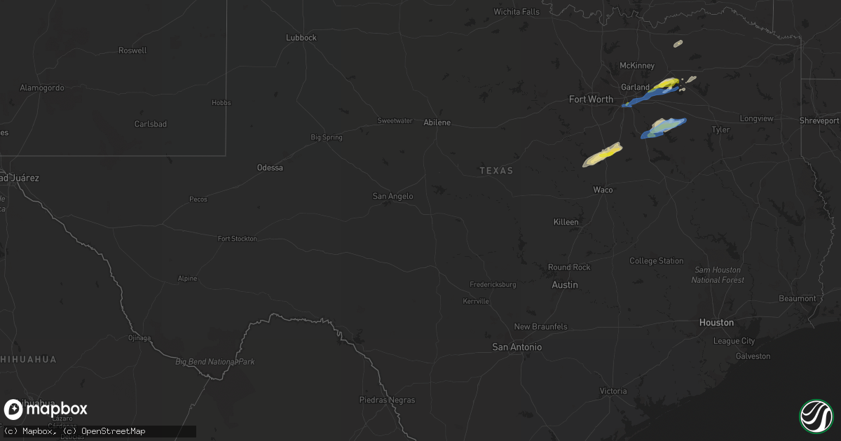
Hail Map in Texas on January 25, 2021
Get this storm
January 25 map
$229
one time, instant access
Download today. No call, no setup
Keep the $229
Bought the map and want the full workflow? Apply the entire $229 to a subscription within 7 days. None of it is wasted.
Every map, not just this one
This buys you this map. Subscription and you get every map we run, in the markets you choose from a few cities to whole states to nationwide. Plus real-time alerts the moment a storm fires.
Contact data
Name, contact info, occupancy, even credit band for addresses in the footprint. You go from where it hit to who to call.
Become the source they trust
Unlimited branding weather history reports on demand. You already have the documented answer ready for the property owner, and you are the one who showed up with it.
Property data and RoofTrace estimates
Pull up any address you have got, its value and the exact code rules for that jurisdiction, straight from One Click Code. Then RoofTrace estimates the squares, pitch, and roof value, priced the way you price.
Storm reports in Texas
Texas
| Date | Description |
|---|---|
| 01/25/20217:35 AM CST | Wood utility pole snapped in south canton. |
| 01/25/20217:24 AM CST | 1.25 inch hail reported at sh198 and us175. |
| 01/25/20217:15 AM CST | Quarter size hail on fm3396 between sh274 and fm2613. |
| 01/25/20217:03 AM CST | Delayed report---multiple trees down and damage to trailers and outbuildings one mile southeast of chatfield. Report relayed via navarro county oem. |
| 01/25/20216:43 AM CST | Storm spotter report of 1.25 hail. |
| 01/25/20216:38 AM CST | At 1238 AM CST, severe thunderstorms were located along a line extending from near Iowa Park to 4 miles northeast of Holliday to 8 miles north of Archer City, moving northeast at 65 mph. HAZARD...70 mph wind gusts and ping pong ball size hail. SOURCE...Radar indicated. IMPACT...People and animals outdoors will be injured. Expect hail damage to roofs, siding, windows, and vehicles. Expect considerable tree damage. Wind damage is also likely to mobile homes, roofs, and outbuildings. Locations impacted include... Wichita Falls, Burkburnett, Waurika, Iowa Park, Holliday, Temple, Ryan, Petrolia, Byers, Dean, Randlett, Jolly, Hastings, Addington, Sugden, Waurika Lake, Sheppard AFB, Corum, Lakeside City and Pleasant Valley. |
| 01/25/20216:31 AM CST | Delayed report---minor damage to roofs/metal garages. Two trees blown down. Report relayed via hill county oem. |
| 01/25/20216:31 AM CST | At 1231 AM CST, severe thunderstorms were located along a line extending from 6 miles northeast of Electra to 6 miles northwest of Iowa Park to 8 miles northwest of Holliday, moving northeast at 70 mph. HAZARD...Two inch hail and the potential for accumulating, small hail. SOURCE...Radar indicated. IMPACT...People and animals outdoors will be injured. Expect damage to roofs, siding, windows, and vehicles. Locations impacted include... Northwestern Wichita Falls, Lawton, Burkburnett, Walters, Iowa Park, Geronimo, Grandfield, Temple, Randlett, Devol, Cookietown, southeastern Fort Sill, Pleasant Valley, Hulen and Cashion. |
| 01/25/20211:22 AM CST | At 721 AM CST, severe thunderstorms were located along a line extending from 7 miles northeast of Manchester to near Bagwell to near Deport to near Bogata to 7 miles northwest of Hagansport, moving northeast at 60 mph. HAZARD...60 mph wind gusts and quarter size hail. SOURCE...Radar indicated. IMPACT...Hail damage to vehicles is expected. Expect wind damage to roofs, siding, and trees. Locations impacted include... Clarksville, Idabel, Broken Bow, Bogata, Bagwell, Manchester, Detroit, Annona, Haworth, Garvin, Eagletown, Farmers Hill, Negley, Harris, Cuthand, Goodwater, Silver City, English, Holly Creek and Johntown. |
| 01/25/20211:15 AM CST | At 714 AM CST, severe thunderstorms were located along a line extending from near Blossom to Sulphur Springs, moving northeast at 60 mph. HAZARD...60 mph wind gusts and quarter size hail. SOURCE...Radar indicated. IMPACT...Hail damage to vehicles is expected. Expect wind damage to roofs, siding, and trees. Locations impacted include... Paris, Sulphur Springs, Blossom, Como, Deport, Tira and Sun Valley.This includes Interstate 30 between mile markers 121 and 142. |
| 01/25/202112:56 AM CST | At 655 AM CST, a severe thunderstorm was located near Alma, or near Ennis, moving northeast at 50 mph. HAZARD...60 mph wind gusts and quarter size hail. SOURCE...Radar indicated. IMPACT...Hail damage to vehicles is expected. Expect wind damage to roofs, siding, and trees. Locations impacted include... Corsicana, Ennis, Gun Barrel City, Canton, Mabank, Malakoff, Tool, Kerens, Seven Points, Edgewood, Kemp, Eustace, Trinidad, Blooming Grove, Bardwell, Fruitvale, Grays Prairie, Alma, Enchanted Oaks and Barry.This includes the following highways... Interstate 20 between mile markers 514 and 529. Interstate 45 between mile markers 228 and 256. |
| 01/25/202112:30 AM CST | At 630 AM CST, a severe thunderstorm was located 5 miles southeast of Royse City, or 10 miles north of Terrell, moving northeast at 50 mph. HAZARD...60 mph wind gusts and quarter size hail. SOURCE...Radar indicated. IMPACT...Hail damage to vehicles is expected. Expect wind damage to roofs, siding, and trees. Locations impacted include... Greenville, Terrell, Sulphur Springs, Commerce, Royse City, West Tawakoni, Quinlan, Caddo Mills, Emory, East Tawakoni, Cumby, Campbell, Hawk Cove, Point and Lone Oak.This includes Interstate 30 between mile markers 79 and 121. |
| 01/25/202112:20 AM CST | At 620 AM CST, a severe thunderstorm was located near Whitney, or 7 miles southwest of Hillsboro, moving northeast at 60 mph. HAZARD...60 mph wind gusts and quarter size hail. SOURCE...Radar indicated. IMPACT...Hail damage to vehicles is expected. Expect wind damage to roofs, siding, and trees. Locations impacted include... Ennis, Hillsboro, Whitney, Italy, Itasca, Blooming Grove, Bardwell, Barry, Bynum, Carl's Corner, Milford, Frost, Abbott, Emhouse, Mertens and Aquilla.This includes the following highways... Interstate 35 between mile markers 355 and 369. Interstate 35W between mile markers 1 and 7. Interstate 35E between mile markers 371 and 392. |
| 01/25/202112:06 AM CST | At 606 AM CST, a severe thunderstorm was located near Dallas, moving northeast at 55 mph. HAZARD...Half dollar size hail. SOURCE...Radar indicated. IMPACT...Damage to vehicles is possible. Locations impacted include... Dallas, Garland, Mesquite, Rowlett, Desoto, Cedar Hill, Duncanville, Rockwall, Lancaster, Balch Springs, University Park, Sachse, Terrell, Seagoville, Forney, Glenn Heights, Highland Park, Hutchins, Cockrell Hill and Royse City. |
| 01/24/202110:58 PM CST | At 458 AM CST, a severe thunderstorm was located 4 miles north of Colbert, moving northeast at 70 mph. HAZARD...60 mph wind gusts and quarter size hail. SOURCE...Radar indicated. IMPACT...Hail damage to vehicles is expected. Expect wind damage to roofs, siding, and trees. Locations impacted include... Durant, Colbert, Caddo, Bokchito, Achille, Bennington, Tushka, Caney, Armstrong, Cartwright, Blue, Lane, eastern Lake Texoma, Calera, Bentley, McGee Creek Lake and Darwin. |
| 01/24/20217:01 PM CST | At 101 AM CST, severe thunderstorms were located along a line extending from 4 miles southwest of Geronimo to 4 miles southeast of Temple to 3 miles southwest of Petrolia, moving northeast at 65 mph. HAZARD...60 mph wind gusts and quarter size hail. SOURCE...Radar indicated. IMPACT...Hail damage to vehicles is expected. Expect wind damage to roofs, siding, and trees. Locations impacted include... Duncan, Marlow, Walters, Waurika, Healdton, Comanche, Geronimo, Bray, Ringling, Temple, Petrolia, Velma, Byers, Dean, Foster, Tatums, Hastings, Loco, Ratliff City and Addington. |
All States Impacted by Hail Map on January 25, 2021
Cities Impacted by Hail Map on January 25, 2021
- Royse City, TX
- Quinlan, TX
- Greenville, TX
- Thompsons Station, TN
- Canton, TX
- Kemp, TX
- Mabank, TX
- Terrell, TX
- Memphis, TN
- Lone Oak, TX
- Walls, MS
- Lake Cormorant, MS
- Southaven, MS
- Horn Lake, MS
- Honey Grove, TX
- Ladonia, TX
- Point, TX
- Brashear, TX
- Cumby, TX
- Farner, TN
- Turtletown, TN
- Murphy, NC
- Kaufman, TX
- Scurry, TX
- Duck River, TN
- Hampshire, TN
- Williamsport, TN
- Centerville, TN
- Chatfield, TX
- Eustace, TX
- Bynum, TX
- Whitney, TX
- Aquilla, TX
- Milford, TX
- Italy, TX
- Mertens, TX
- Hillsboro, TX
- Ennis, TX
- Emory, TX
- Caddo Mills, TX
- Germantown, TN
- Cordova, TN
- Clifton, TX
- Wolfe City, TX
- Frost, TX
- Abbott, TX
- Sulphur Springs, TX
- Burkesville, KY
- Edmonton, KY
- Breeding, KY
- Bethelridge, KY
- Windsor, KY
- Liberty, KY
- Science Hill, KY
- Columbia, KY
- Russell Springs, KY
- Nancy, KY
- Glens Fork, KY
- Dunnville, KY
- Dallas, GA
- Cartersville, GA
- Acworth, GA
- Marietta, GA
- Kennesaw, GA
- Alpharetta, GA
- Woodstock, GA
- Roswell, GA
- Newnan, GA
- Fayetteville, GA
- Locust Grove, GA
- Griffin, GA
- Hampton, GA
- Brooks, GA
- Shady Dale, GA
- Mansfield, GA
- Monticello, GA
- Newborn, GA
- Madison, GA
- Noxapater, MS
- Louisville, MS
- Kosciusko, MS
- Macon, MS
- Camden, MS
- Carthage, MS
- Philadelphia, MS
- Glendale, AZ
- Phoenix, AZ
- El Mirage, AZ
- Sun City, AZ
- Avondale, AZ
- Litchfield Park, AZ
- Youngtown, AZ
- Peoria, AZ
- Paradise Valley, AZ
- Luke Air Force Base, AZ
- Scottsdale, AZ
- Waddell, AZ
- Surprise, AZ
- Balch Springs, TX
- Mesquite, TX
- Hutchins, TX
- Forney, TX
- Sunnyvale, TX
- Dallas, TX
- Rockwall, TX
- Wills Point, TX
- Rice, TX
- Collierville, TN
- Eads, TN
- Hughes, AR
- Franklin, TN
- College Grove, TN
- Santa Fe, TN
- Columbia, TN
- Spring Hill, TN
- Trussville, AL
- Ashville, AL
- Ohatchee, AL
- Fultondale, AL
- Adamsville, AL
- Gadsden, AL
- Birmingham, AL
- Odenville, AL
- Jacksonville, AL
- Moody, AL
- Ragland, AL
- Mount Olive, AL
- Gardendale, AL
- Pinson, AL
- Springville, AL
- Wellington, AL


