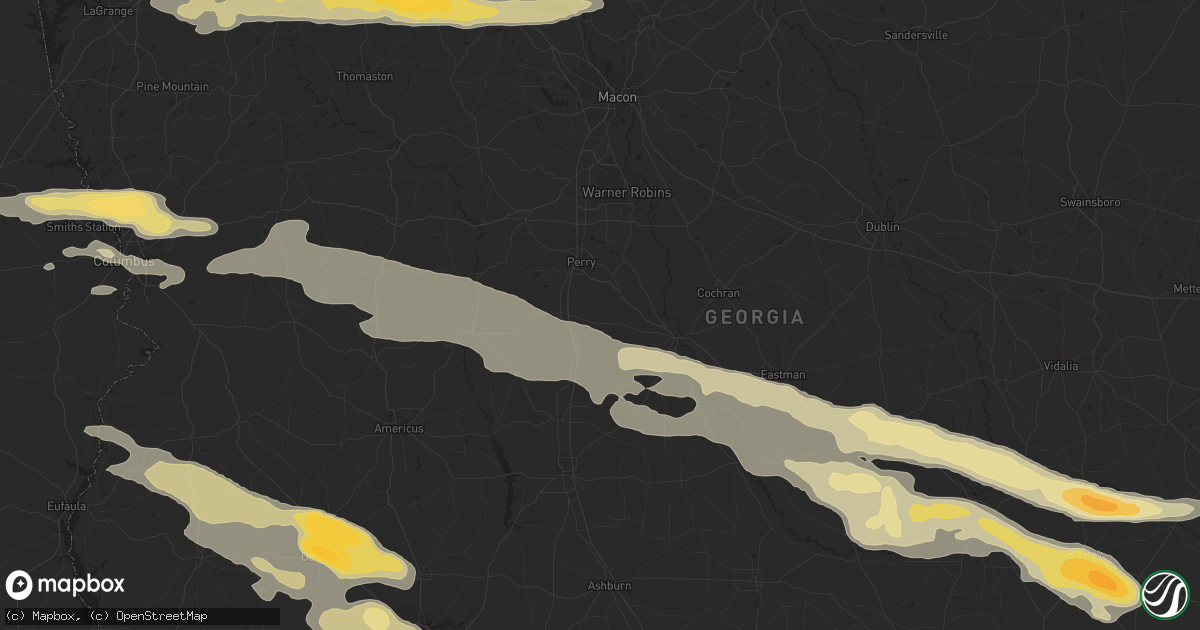
Hail Map in Baxley, GA on January 21, 2012
Get this storm
January 21 map
$229
one time, instant access
Download today. No call, no setup
Keep the $229
Bought the map and want the full workflow? Apply the entire $229 to a subscription within 7 days. None of it is wasted.
Every map, not just this one
This buys you this map. Subscription and you get every map we run, in the markets you choose from a few cities to whole states to nationwide. Plus real-time alerts the moment a storm fires.
Contact data
Name, contact info, occupancy, even credit band for addresses in the footprint. You go from where it hit to who to call.
Become the source they trust
Unlimited branding weather history reports on demand. You already have the documented answer ready for the property owner, and you are the one who showed up with it.
Property data and RoofTrace estimates
Pull up any address you have got, its value and the exact code rules for that jurisdiction, straight from One Click Code. Then RoofTrace estimates the squares, pitch, and roof value, priced the way you price.
Storm reports in Baxley, GA
Baxley, GA
| Date | Description |
|---|---|
| 01/21/20125:45 PM CST | Golfball size hail reported 9 miles north of baxley |
| 01/21/20125:45 PM CST | Golfball size hail reported 9 miles south of baxley |
| 01/20/20126:20 PM CST | Emergency management relayed a report of golfball size hail along highway 15. |
All States Impacted by Hail Map on January 21, 2012
All Cities Impacted by Hail Map on January 21, 2012
- Concord, GA
- Milner, GA
- Forsyth, GA
- Gay, GA
- Williamson, GA
- The Rock, GA
- Barnesville, GA
- Woodbury, GA
- Zebulon, GA
- Meansville, GA
- Baxley, GA
- Atlanta, GA
- Union Springs, AL
- Midway, AL
- Eufaula, AL
- Hurtsboro, AL
- Eastman, GA
- Lithia Springs, GA
- Decatur, GA
- Douglasville, GA
- Fairburn, GA
- Albany, GA
- Leesburg, GA
- Dawson, GA
- Fortson, GA
- Columbus, GA
- Salem, AL
- Smiths Station, AL
- Opelika, AL
- Cataula, GA
- Midland, GA
- Evergreen, AL
- Mauk, GA
- Oglethorpe, GA
- Ideal, GA
- Marshallville, GA
- Elko, GA
- Byromville, GA
- Butler, GA
- Unadilla, GA
- Rupert, GA
- Buena Vista, GA
- Reynolds, GA
- Montezuma, GA
- Box Springs, GA
- Greenville, GA
- Douglas, GA
- Broxton, GA
- Ambrose, GA
- Nicholls, GA
- Shellman, GA
- Richland, GA
- Bronwood, GA
- Parrott, GA
- Lumpkin, GA
- Cuthbert, GA
- McRae Helena, GA
- Jacksonville, GA
- Rhine, GA
- Lumber City, GA
- Milan, GA
- Hazlehurst, GA
- Surrency, GA
- Forest Home, AL
- Georgiana, AL
- Pine Apple, AL
- Greenville, AL
- Smyrna, GA
- Moultrie, GA
- Alabaster, AL
- Montevallo, AL
- Sandersville, GA
- Davisboro, GA
- West Point, GA
- Hamilton, GA
- Valley, AL
- Arlington, AL
- Thomaston, AL
- Glenwood, GA
- Uvalda, GA
- Alamo, GA
- Lagrange, GA
- Hogansville, GA
- Gray, GA
- Luthersville, GA
- Juliette, GA
- Molena, GA
- Barney, GA
- Pavo, GA
- Berlin, GA
- Ozark, AL
- Ariton, AL
- Thomaston, GA
- Manchester, GA
- Enterprise, AL
- Pinehurst, GA
- Macon, GA
- Columbus, MS
- Catherine, AL
- Shorter, AL
- Quitman, GA
- Morven, GA
- Rochelle, GA
- Pineview, GA
- Hawkinsville, GA
- Chauncey, GA
- Troy, AL
- Morris, GA
- Vienna, GA
- Abbeville, GA
- Griffin, GA
- Sycamore, GA
- Chula, GA
- Tifton, GA
- Brundidge, AL
- Jack, AL
- Ramer, AL
- Georgetown, GA
- Omaha, GA
- Leary, GA
- Ocilla, GA
- Letohatchee, AL
- Hope Hull, AL
- Hayneville, AL
- Cusseta, AL
- Columbiana, AL
- Sylacauga, AL
- Childersburg, AL
- Wilsonville, AL
- Junction City, GA
- Valdosta, GA
- Dixie, GA
- Warthen, GA
- Tuskegee, AL
- Funston, GA
- Phenix City, AL
- Upatoi, GA
- Fort Benning, GA
- Fort Mitchell, AL
- Talbotton, GA
- Woodland, GA
- Culloden, GA
- Eatonton, GA
- Marietta, GA
- Auburn, AL
- Skipperville, AL
- Yatesville, GA
- Carrollton, GA
- Temple, GA
- Notasulga, AL
- Ellaville, GA
- Waverly Hall, GA
- Newbern, AL
- West Point, MS
- Doerun, GA
- Sylvester, GA
- Clio, AL
- Bartow, GA
- Fort Valley, GA
- Knoxville, GA
- Ashburn, GA
- Cusseta, GA
- Fitzgerald, GA
- Millwood, GA
- West Green, GA
- Wray, GA
- Lapine, AL
- Montgomery, AL
- Adel, GA
- Norman Park, GA
- Sweet Water, AL
- Union City, GA
- Riverdale, GA
- Palmetto, GA
- Red Level, AL
- Jonesboro, GA
- Morrow, GA
- Forest Park, GA
- Winston, GA
- Glennville, GA
- Denton, GA


