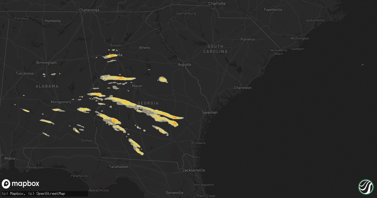
Hail Map on January 21, 2012
Get this storm
January 21 map
$229
one time, instant access
Download today. No call, no setup
Keep the $229
Bought the map and want the full workflow? Apply the entire $229 to a subscription within 7 days. None of it is wasted.
Every map, not just this one
This buys you this map. Subscription and you get every map we run, in the markets you choose from a few cities to whole states to nationwide. Plus real-time alerts the moment a storm fires.
Contact data
Name, contact info, occupancy, even credit band for addresses in the footprint. You go from where it hit to who to call.
Become the source they trust
Unlimited branding weather history reports on demand. You already have the documented answer ready for the property owner, and you are the one who showed up with it.
Property data and RoofTrace estimates
Pull up any address you have got, its value and the exact code rules for that jurisdiction, straight from One Click Code. Then RoofTrace estimates the squares, pitch, and roof value, priced the way you price.
States Impacted by Hail Map on January 21, 2012
Storm reports
Alabama
| Date | Description |
|---|---|
| 01/21/20122:50 PM CST | A local report indicates 1.00 inch wind near 6 SW GREENVILLE |
| 01/21/20122:25 PM CST | Dime to quarter size hail reported along highway 31 south of greenville. Time radar estimated. |
| 01/21/201210:30 AM CST | Large trees reported down across highway 22 in the community of dickert. Numerous powerlines reported down in the area as well. A chrurch steeple was toppled near the a |
South Carolina
| Date | Description |
|---|---|
| 01/21/20124:34 PM CST | A tree was blown down onto power lines along scotia-furman highway. |
Tennessee
| Date | Description |
|---|---|
| 01/21/20128:45 AM CST | Area of metal roofing partially peeled back on a home on williams road. |
Georgia
| Date | Description |
|---|---|
| 01/21/20125:56 PM CST | Dime to quarter size hail currently falling throughout albany |
| 01/21/20125:55 PM CST | Hail around quarter size estimated at the flash foods store on east oakridge drive |
| 01/21/20125:45 PM CST | Quarter size hail reported at 17 north osage lane |
| 01/21/20125:45 PM CST | Golfball size hail reported 9 miles north of baxley |
| 01/21/20125:45 PM CST | Golfball size hail reported 9 miles south of baxley |
| 01/21/20125:44 PM CST | A local report indicates 1.00 inch wind near NE HAZLEHURST |
| 01/21/20125:40 PM CST | Tree down near 200 hickory grove road. |
| 01/21/20125:35 PM CST | Dime-size hail covering the ground northwest of albany with a few quarter size stones. |
| 01/21/20125:15 PM CST | A local report indicates 1.00 inch wind near 2 S UVALDA |
| 01/21/20125:10 PM CST | Tree down along the 100 block of east westerlee drive |
| 01/21/20125:02 PM CST | Hail the size of quarters estimated along pinewood road. |
| 01/21/20124:45 PM CST | Public estimated hail to golf ball size covering the yard in dawson. Reported via broadcast media facebook page. |
| 01/21/20124:43 PM CST | Tree down along rigsby road. |
| 01/21/20124:31 PM CST | A local report indicates 1.00 inch wind near 2 W MCRAE |
| 01/21/20124:11 PM CST | Tree down near benevolence |
| 01/21/20124:06 PM CST | 1 tree down off hwy 87 s in eastman. |
| 01/21/20124:05 PM CST | A local report indicates 1.00 inch wind near 3 S EASTMAN |
| 01/21/20124:04 PM CST | *** 1 inj *** a tree fell on a mobile home trapping the occupant inside. The occupant was rescued and transported to the hospital with unspecified injuries. |
| 01/21/20123:19 PM CST | Numerous trees...atleast a half dozen...were down from pinehurst to unadilla...and one power pole was snapped. |
| 01/21/20123:19 PM CST | Damage survey determined that an ef0 tornado touched down in northern dooly county just northwest of pinehurst and followed a sporadic 5.5-mile long ese path. Approxima |
| 01/21/20122:49 PM CST | 911 report from volunteer fire fighter...possible tornado...trees down. One house along hwy 49 north of montezuma sustained major damage...and some barns were destroyed |
| 01/21/20122:45 PM CST | Damage survey team determined that an ef0 tornado touched down along ga highway 128 just north of oglethorpe...then strengthed to an ef1 tornado near four points where |
| 01/21/20121:58 PM CST | A tree down near ridge road. |
| 01/21/20121:20 PM CST | Columbus media relayed a report of trees across the road in northern muscogee county. |
| 01/21/20121:19 PM CST | Numerous reports of large hail across the northern part of muscogee county. Sizes ranging from quarter to golf ball. |
| 01/21/20121:15 PM CST | 10-12 trees down along hwy 219 and 116. |
| 01/21/201212:50 PM CST | Tree down near gray |
| 01/21/201212:45 PM CST | A local report indicates 1.00 inch wind near JULIETTE |
| 01/21/201212:15 PM CST | Three trees and powerlines down on transformer. |
| 01/21/201212:11 PM CST | A local report indicates 1.75 inch wind near BARNESVILLE |
| 01/21/201212:09 PM CST | A local report indicates 1.50 inch wind near BARNESVILLE |
| 01/21/201212:05 PM CST | A local report indicates 1.00 inch wind near BARNESVILLE |
| 01/21/201212:03 PM CST | Hail quarter to golfball sized |
| 01/21/201211:58 AM CST | Two trees downed. |
| 01/21/201211:56 AM CST | A local report indicates 1.00 inch wind near MEANSVILLE |
| 01/21/201211:44 AM CST | A local report indicates 1.00 inch wind near CONCORD |
| 01/21/201211:31 AM CST | One tree down near howard road. Minor wind damage to recreational baseball field...including a score board and dugout shelters. Minor damage to porch of senior center. |
| 01/21/201211:15 AM CST | Damage to 8-10 residential properties along the 700-1000 block of gordon road off hwy 16. Additional damage at intersection with martin mill road. Minor damage...if any |
| 01/21/201211:10 AM CST | A damage survey team determined that an ef-0 tornado touched down northeast of moreland in south central coweta county near the intersection of alex stephens and gordon |
| 01/21/201210:57 AM CST | Numerous trees down along hwy 34e |
| 01/21/201210:40 AM CST | Signs at shopping plaza blown out and others twisted at fairburn road and shawnee trail. Several businesses along fairburn road sustained minor structural damage to the |
| 01/21/201210:00 AM CST | Two trees down near tibor road and titner road. |
| 01/21/20129:45 AM CST | County reports trees down highway 76. |
| 01/21/20129:30 AM CST | A local report indicates 1.75 inch wind near SANDTOWN |
| 01/20/20127:15 PM CST | Quarter size hail reported nw of douglas |
| 01/20/20127:10 PM CST | Tree limbs were reported down. |
| 01/20/20126:20 PM CST | Emergency management relayed a report of golfball size hail along highway 15. |
| 01/20/20126:05 PM CST | Hail of at least quarter size estimated at the flash foods store on holly drive sometime between 7 and 710 pm est. |
Cities Impacted by Hail Map on January 21, 2012
- Concord, GA
- Milner, GA
- Forsyth, GA
- Gay, GA
- Williamson, GA
- The Rock, GA
- Barnesville, GA
- Woodbury, GA
- Zebulon, GA
- Meansville, GA
- Baxley, GA
- Atlanta, GA
- Union Springs, AL
- Midway, AL
- Eufaula, AL
- Hurtsboro, AL
- Eastman, GA
- Lithia Springs, GA
- Decatur, GA
- Douglasville, GA
- Fairburn, GA
- Albany, GA
- Leesburg, GA
- Dawson, GA
- Fortson, GA
- Columbus, GA
- Salem, AL
- Smiths Station, AL
- Opelika, AL
- Cataula, GA
- Midland, GA
- Evergreen, AL
- Mauk, GA
- Oglethorpe, GA
- Ideal, GA
- Marshallville, GA
- Elko, GA
- Byromville, GA
- Butler, GA
- Unadilla, GA
- Rupert, GA
- Buena Vista, GA
- Reynolds, GA
- Montezuma, GA
- Box Springs, GA
- Greenville, GA
- Douglas, GA
- Broxton, GA
- Ambrose, GA
- Nicholls, GA
- Shellman, GA
- Richland, GA
- Bronwood, GA
- Parrott, GA
- Lumpkin, GA
- Cuthbert, GA
- McRae Helena, GA
- Jacksonville, GA
- Rhine, GA
- Lumber City, GA
- Milan, GA
- Hazlehurst, GA
- Surrency, GA
- Forest Home, AL
- Georgiana, AL
- Pine Apple, AL
- Greenville, AL
- Smyrna, GA
- Moultrie, GA
- Alabaster, AL
- Montevallo, AL
- Sandersville, GA
- Davisboro, GA
- West Point, GA
- Hamilton, GA
- Valley, AL
- Arlington, AL
- Thomaston, AL
- Glenwood, GA
- Uvalda, GA
- Alamo, GA
- Lagrange, GA
- Hogansville, GA
- Gray, GA
- Luthersville, GA
- Juliette, GA
- Molena, GA
- Barney, GA
- Pavo, GA
- Berlin, GA
- Ozark, AL
- Ariton, AL
- Thomaston, GA
- Manchester, GA
- Enterprise, AL
- Pinehurst, GA
- Macon, GA
- Columbus, MS
- Catherine, AL
- Shorter, AL
- Quitman, GA
- Morven, GA
- Rochelle, GA
- Pineview, GA
- Hawkinsville, GA
- Chauncey, GA
- Troy, AL
- Morris, GA
- Vienna, GA
- Abbeville, GA
- Griffin, GA
- Sycamore, GA
- Chula, GA
- Tifton, GA
- Brundidge, AL
- Jack, AL
- Ramer, AL
- Georgetown, GA
- Omaha, GA
- Leary, GA
- Ocilla, GA
- Letohatchee, AL
- Hope Hull, AL
- Hayneville, AL
- Cusseta, AL
- Columbiana, AL
- Sylacauga, AL
- Childersburg, AL
- Wilsonville, AL
- Junction City, GA
- Valdosta, GA
- Dixie, GA
- Warthen, GA
- Tuskegee, AL
- Funston, GA
- Phenix City, AL
- Upatoi, GA
- Fort Benning, GA
- Fort Mitchell, AL
- Talbotton, GA
- Woodland, GA
- Culloden, GA
- Eatonton, GA
- Marietta, GA
- Auburn, AL
- Skipperville, AL
- Yatesville, GA
- Carrollton, GA
- Temple, GA
- Notasulga, AL
- Ellaville, GA
- Waverly Hall, GA
- Newbern, AL
- West Point, MS
- Doerun, GA
- Sylvester, GA
- Clio, AL
- Bartow, GA
- Fort Valley, GA
- Knoxville, GA
- Ashburn, GA
- Cusseta, GA
- Fitzgerald, GA
- Millwood, GA
- West Green, GA
- Wray, GA
- Lapine, AL
- Montgomery, AL
- Adel, GA
- Norman Park, GA
- Sweet Water, AL
- Union City, GA
- Riverdale, GA
- Palmetto, GA
- Red Level, AL
- Jonesboro, GA
- Morrow, GA
- Forest Park, GA
- Winston, GA
- Glennville, GA
- Denton, GA