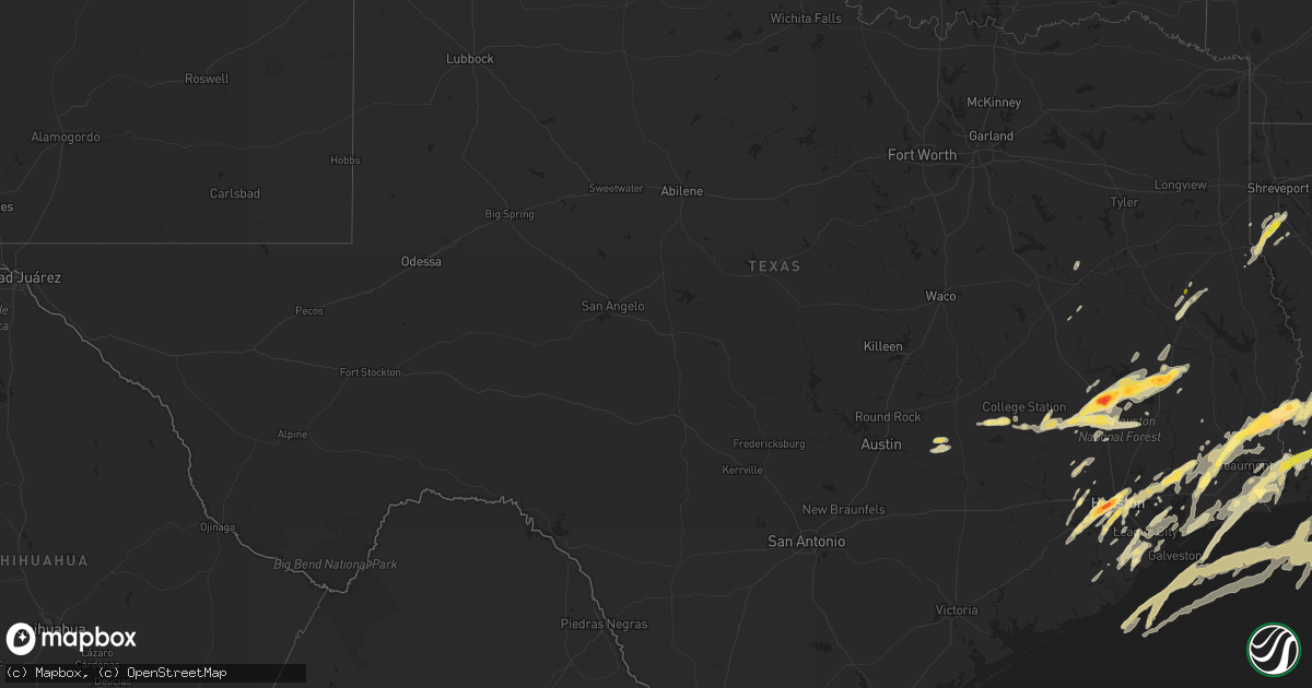
Hail Map in Texas on January 8, 2016
Get this storm
January 8 map
$229
one time, instant access
Download today. No call, no setup
Keep the $229
Bought the map and want the full workflow? Apply the entire $229 to a subscription within 7 days. None of it is wasted.
Every map, not just this one
This buys you this map. Subscription and you get every map we run, in the markets you choose from a few cities to whole states to nationwide. Plus real-time alerts the moment a storm fires.
Contact data
Name, contact info, occupancy, even credit band for addresses in the footprint. You go from where it hit to who to call.
Become the source they trust
Unlimited branding weather history reports on demand. You already have the documented answer ready for the property owner, and you are the one who showed up with it.
Property data and RoofTrace estimates
Pull up any address you have got, its value and the exact code rules for that jurisdiction, straight from One Click Code. Then RoofTrace estimates the squares, pitch, and roof value, priced the way you price.
Storm reports in Texas
Texas
| Date | Description |
|---|---|
| 01/08/20165:57 PM CST | Broadcast media received several reports of hail on the southside of nacogdoches. |
| 01/08/201612:45 AM CST | Dime to quarter sized hail |
| 01/08/201612:45 AM CST | Dime to quarter sized hail |
| 01/07/20169:45 PM CST | Public sent in picture via facebook of half dollar size hail near port arthur. Time estimated by radar. |
| 01/07/20167:32 PM CST | Public picture on facebook indicates ping pong ball size hail near buna. |
| 01/07/20167:31 PM CST | Quarter size hail and larger covering the ground 2 miles north of downtown houston. |
| 01/07/20167:19 PM CST | Pea to golfball size hail reported on gulfton street |
| 01/07/20167:12 PM CST | A local report indicates 2.50 inch wind near BELLAIRE |
| 01/07/20167:09 PM CST | A local report indicates 1.75 inch wind near 1 S BELLAIRE |
| 01/07/20167:00 PM CST | A local report indicates 1.00 inch wind near LUMBERTON |
| 01/07/20166:55 PM CST | Sheriff office reported golfball size hail in leggett |
| 01/07/20166:32 PM CST | Quarter size hail between liberty and mont belvieu |
| 01/07/20166:27 PM CST | Gas station reported golfball size hail at highway 190 and counts road |
| 01/07/20166:03 PM CST | Golfball hail reported in the elkins lake subdivision |
| 01/07/20166:00 PM CST | Tennis ball size hail reported along fm 2296 between huntsville and new waverly |
| 01/07/20166:00 PM CST | Half dollar size hail reported south of huntsville |
All States Impacted by Hail Map on January 8, 2016
Cities Impacted by Hail Map on January 8, 2016
- Brazoria, TX
- Angleton, TX
- Devers, TX
- Merryville, LA
- Kountze, TX
- Call, TX
- Lumberton, TX
- Nome, TX
- Silsbee, TX
- Beaumont, TX
- Sour Lake, TX
- Buna, TX
- Oakdale, LA
- Saint Martinville, LA
- Grosse Tete, LA
- Santa Fe, TX
- League City, TX
- Dickinson, TX
- Singer, LA
- Longville, LA
- Lake Village, AR
- Eudora, AR
- Friendswood, TX
- Webster, TX
- Bellaire, TX
- Missouri City, TX
- Richmond, TX
- Needville, TX
- Rosenberg, TX
- Sugar Land, TX
- Stafford, TX
- Houston, TX
- Oberlin, LA
- Elton, LA
- Crosby, TX
- Highlands, TX
- Huntsville, TX
- Port Arthur, TX
- Paige, TX
- College Station, TX
- Navasota, TX
- Somerville, TX
- Sugartown, LA
- Deridder, LA
- Jennings, LA
- Roanoke, LA
- Welsh, LA
- Basile, LA
- Iowa, LA
- Kinder, LA
- Lake Charles, LA
- Bell City, LA
- Lacassine, LA
- Galena Park, TX
- Liverpool, TX
- Alvin, TX
- Dequincy, LA
- Groves, TX
- Bridge City, TX
- Cameron, LA
- Sulphur, LA
- Orange, TX
- Westlake, LA
- Vinton, LA
- McDade, TX
- Montgomery, TX
- Conroe, TX
- Willis, TX
- Prescott, AR
- Richards, TX
- Anderson, TX
- Oakhurst, TX
- Plantersville, TX
- Moscow, TX
- New Waverly, TX
- Onalaska, TX
- Cleveland, TX
- Livingston, TX
- Coldspring, TX
- Pointblank, TX
- Trinity, TX
- Corrigan, TX
- Creole, LA
- Nacogdoches, TX
- Lufkin, TX
- Anahuac, TX
- La Porte, TX
- Seabrook, TX
- Kemah, TX
- Baytown, TX
- Gueydan, LA
- Kaplan, LA
- Farmerville, LA
- Downsville, LA
- Grand Chenier, LA
- Pearland, TX
- Logansport, LA
- Gloster, LA
- Grand Cane, LA
- Frierson, LA
- Greenville, MS
- Breaux Bridge, LA
- Cheneyville, LA
- Fresno, TX
- Keatchie, LA
- Katy, TX
- Liberty, TX
- Caldwell, TX
- Holcomb, MS
- Lincoln, TX
- Lexington, TX
- Deweyville, TX
- Vidor, TX
- Winnie, TX
- Starks, LA
- Bon Wier, TX
- Pitkin, LA
- China, TX
- Tomball, TX
- Hockley, TX
- Cypress, TX
- Magnolia, TX
- Grant, LA
- Dry Creek, LA
- Center, TX
- Humble, TX
- Pasadena, TX
- Deer Park, TX
- Pinehurst, TX
- Rosharon, TX
- Hull, TX
- Dayton, TX
- Mamou, LA
- Eunice, LA
- Chester, TX
- Groveton, TX
- Brenham, TX
- Nederland, TX
- Port Neches, TX
- Elizabeth, LA
- Hankamer, TX
- Glenmora, LA
- Hackberry, LA
- Channelview, TX
- Mittie, LA
- South Houston, TX
- Danbury, TX
- Mansfield, LA
- Joaquin, TX
- La Marque, TX
- Hitchcock, TX
- Texas City, TX
- Church Point, LA
- Branch, LA
- Alexandria, LA
- Lecompte, LA
- Manvel, TX
- Opelousas, LA
- Stonewall, LA
- Tennessee Colony, TX
- Centerville, TX
- Snook, TX
- Alligator, MS
- Duncan, MS
- Clarksdale, MS
- Saratoga, TX
- Oakwood, TX
- Inverness, MS
- Gurdon, AR
- Montalba, TX
- Palestine, TX
- Bacliff, TX
- Shepherd, TX
- Burlison, TN
- Covington, TN
- Mount Ida, AR
- Washington, LA


