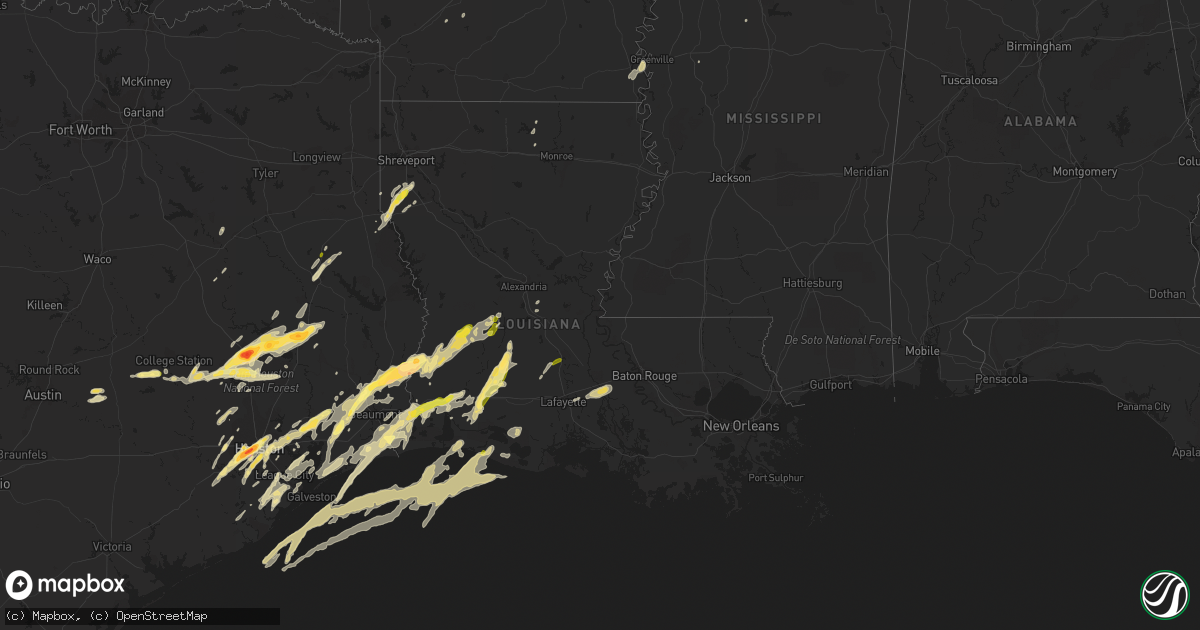
Hail Map in Louisiana on January 8, 2016
Get this storm
January 8 map
$229
one time, instant access
Download today. No call, no setup
Keep the $229
Bought the map and want the full workflow? Apply the entire $229 to a subscription within 7 days. None of it is wasted.
Every map, not just this one
This buys you this map. Subscription and you get every map we run, in the markets you choose from a few cities to whole states to nationwide. Plus real-time alerts the moment a storm fires.
Contact data
Name, contact info, occupancy, even credit band for addresses in the footprint. You go from where it hit to who to call.
Become the source they trust
Unlimited branding weather history reports on demand. You already have the documented answer ready for the property owner, and you are the one who showed up with it.
Property data and RoofTrace estimates
Pull up any address you have got, its value and the exact code rules for that jurisdiction, straight from One Click Code. Then RoofTrace estimates the squares, pitch, and roof value, priced the way you price.
Storm reports in Louisiana
Louisiana
| Date | Description |
|---|---|
| 01/08/201612:05 AM CST | Skywarn spotter reports quarter size hail north of opelousas. |
| 01/07/20169:15 PM CST | Public photo submitted to local news media shows ping pong ball size hail in fields. Time estimated by radar. |
| 01/07/20168:52 PM CST | Trees down at 2127 hwy 516 in the fryeburg community. |
| 01/07/20168:30 PM CST | Numerous large limbs were downed by high winds along bistineau lake road along the eastern side of lake bistineau near the bossier/bienville parish line. |
| 01/07/20168:25 PM CST | Numerous large limbs were downed by high winds along highway 154 east of elm grove just west of the lake bistineau dam in southern bossier parish. |
| 01/07/20168:22 PM CST | Trees down at 2400 atkins clark rd near the elm grove community. |
| 01/07/20168:10 PM CST | Picture from tv meterologist facebook page. |
| 01/07/20167:35 PM CST | Meteorologist from 26th operational weather squadron reported half dollar size hail on hwy 171. |
All States Impacted by Hail Map on January 8, 2016
Cities Impacted by Hail Map on January 8, 2016
- Brazoria, TX
- Angleton, TX
- Devers, TX
- Merryville, LA
- Kountze, TX
- Call, TX
- Lumberton, TX
- Nome, TX
- Silsbee, TX
- Beaumont, TX
- Sour Lake, TX
- Buna, TX
- Oakdale, LA
- Saint Martinville, LA
- Grosse Tete, LA
- Santa Fe, TX
- League City, TX
- Dickinson, TX
- Singer, LA
- Longville, LA
- Lake Village, AR
- Eudora, AR
- Friendswood, TX
- Webster, TX
- Bellaire, TX
- Missouri City, TX
- Richmond, TX
- Needville, TX
- Rosenberg, TX
- Sugar Land, TX
- Stafford, TX
- Houston, TX
- Oberlin, LA
- Elton, LA
- Crosby, TX
- Highlands, TX
- Huntsville, TX
- Port Arthur, TX
- Paige, TX
- College Station, TX
- Navasota, TX
- Somerville, TX
- Sugartown, LA
- Deridder, LA
- Jennings, LA
- Roanoke, LA
- Welsh, LA
- Basile, LA
- Iowa, LA
- Kinder, LA
- Lake Charles, LA
- Bell City, LA
- Lacassine, LA
- Galena Park, TX
- Liverpool, TX
- Alvin, TX
- Dequincy, LA
- Groves, TX
- Bridge City, TX
- Cameron, LA
- Sulphur, LA
- Orange, TX
- Westlake, LA
- Vinton, LA
- McDade, TX
- Montgomery, TX
- Conroe, TX
- Willis, TX
- Prescott, AR
- Richards, TX
- Anderson, TX
- Oakhurst, TX
- Plantersville, TX
- Moscow, TX
- New Waverly, TX
- Onalaska, TX
- Cleveland, TX
- Livingston, TX
- Coldspring, TX
- Pointblank, TX
- Trinity, TX
- Corrigan, TX
- Creole, LA
- Nacogdoches, TX
- Lufkin, TX
- Anahuac, TX
- La Porte, TX
- Seabrook, TX
- Kemah, TX
- Baytown, TX
- Gueydan, LA
- Kaplan, LA
- Farmerville, LA
- Downsville, LA
- Grand Chenier, LA
- Pearland, TX
- Logansport, LA
- Gloster, LA
- Grand Cane, LA
- Frierson, LA
- Greenville, MS
- Breaux Bridge, LA
- Cheneyville, LA
- Fresno, TX
- Keatchie, LA
- Katy, TX
- Liberty, TX
- Caldwell, TX
- Holcomb, MS
- Lincoln, TX
- Lexington, TX
- Deweyville, TX
- Vidor, TX
- Winnie, TX
- Starks, LA
- Bon Wier, TX
- Pitkin, LA
- China, TX
- Tomball, TX
- Hockley, TX
- Cypress, TX
- Magnolia, TX
- Grant, LA
- Dry Creek, LA
- Center, TX
- Humble, TX
- Pasadena, TX
- Deer Park, TX
- Pinehurst, TX
- Rosharon, TX
- Hull, TX
- Dayton, TX
- Mamou, LA
- Eunice, LA
- Chester, TX
- Groveton, TX
- Brenham, TX
- Nederland, TX
- Port Neches, TX
- Elizabeth, LA
- Hankamer, TX
- Glenmora, LA
- Hackberry, LA
- Channelview, TX
- Mittie, LA
- South Houston, TX
- Danbury, TX
- Mansfield, LA
- Joaquin, TX
- La Marque, TX
- Hitchcock, TX
- Texas City, TX
- Church Point, LA
- Branch, LA
- Alexandria, LA
- Lecompte, LA
- Manvel, TX
- Opelousas, LA
- Stonewall, LA
- Tennessee Colony, TX
- Centerville, TX
- Snook, TX
- Alligator, MS
- Duncan, MS
- Clarksdale, MS
- Saratoga, TX
- Oakwood, TX
- Inverness, MS
- Gurdon, AR
- Montalba, TX
- Palestine, TX
- Bacliff, TX
- Shepherd, TX
- Burlison, TN
- Covington, TN
- Mount Ida, AR
- Washington, LA


