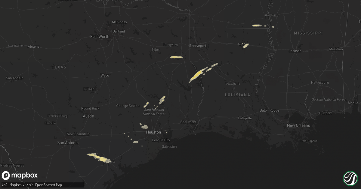
Hail Map in Texas on January 7, 2023
Get this storm
January 7 map
$229
one time, instant access
Download today. No call, no setup
Keep the $229
Bought the map and want the full workflow? Apply the entire $229 to a subscription within 7 days. None of it is wasted.
Every map, not just this one
This buys you this map. Subscription and you get every map we run, in the markets you choose from a few cities to whole states to nationwide. Plus real-time alerts the moment a storm fires.
Contact data
Name, contact info, occupancy, even credit band for addresses in the footprint. You go from where it hit to who to call.
Become the source they trust
Unlimited branding weather history reports on demand. You already have the documented answer ready for the property owner, and you are the one who showed up with it.
Property data and RoofTrace estimates
Pull up any address you have got, its value and the exact code rules for that jurisdiction, straight from One Click Code. Then RoofTrace estimates the squares, pitch, and roof value, priced the way you price.
Storm reports in Texas
Texas
| Date | Description |
|---|---|
| 01/07/20235:32 AM CST | At 1132 PM CST, a severe thunderstorm was located near Mission Valley, or 10 miles south of Cuero, moving east at 20 mph. HAZARD...60 mph wind gusts and penny size hail. SOURCE...Radar indicated. IMPACT...Expect damage to roofs, siding, and trees. Locations impacted include... Mission Valley, Schroeder, Weser, Ander and Nursery. This includes the following highways... US Highway 183 between mile markers 628 and 632. US Highway 87 between mile markers 796 and 804. |
| 01/07/20235:15 AM CST | At 1115 PM CST, a severe thunderstorm was located 7 miles north of Milam, or 27 miles southeast of Center, moving northeast at 40 mph. HAZARD...60 mph wind gusts and quarter size hail. SOURCE...Radar indicated. IMPACT...Hail damage to vehicles is expected. Expect wind damage to roofs, siding, and trees. Locations impacted include... Milam, Many, Zwolle, Converse, Oak Grove, Pleasant Hill, Noble, Robeline, Sexton, Belmont, Pelican, Toledo Bend Reservoir North, Marthaville, Rambin and Ajax. |
| 01/07/20234:42 AM CST | At 1042 PM CST, severe thunderstorms were located along a line extending from 6 miles southwest of Hooks Airport to near Cypress to near Katy, moving southeast at 10 mph. HAZARD...Quarter size hail. SOURCE...Radar indicated. IMPACT...Damage to vehicles is expected. Locations impacted include... Katy, Tomball, Jersey Village, Bunker Hill Village, Spring Branch North, Eldridge / West Oaks, Greater Greenspoint, Spring Branch West, Addicks Park Ten, Spring Valley, Mission Bend, Hedwig Village, Hilshire Village, Spring Branch East, Spring Branch Central, Fairbanks / Northwest Crossing, Langwood, Willowbrook, Acres Home and Hooks Airport. |
| 01/07/20234:33 AM CST | At 1032 PM CST, a severe thunderstorm was located over Yorktown, moving east at 20 mph. HAZARD...60 mph wind gusts and quarter size hail. SOURCE...Radar indicated. IMPACT...Hail damage to vehicles is expected. Expect wind damage to roofs, siding, and trees. Locations impacted include... Yorktown, Thomaston, Arneckville, Meyersville and Gruenau. |
| 01/07/20233:58 AM CST | At 958 PM CST, a severe thunderstorm was located 7 miles northwest of Runge, or 10 miles northeast of Karnes City, moving southeast at 10 mph. HAZARD...60 mph wind gusts and quarter size hail. SOURCE...Radar indicated. IMPACT...Hail damage to vehicles is expected. Expect wind damage to roofs, siding, and trees. Locations impacted include... Runge, Nordheim, Cotton Patch, New Davy, Ecleto and Helena. |
| 01/07/20233:53 AM CST | At 952 PM CST, a severe thunderstorm was located over southeastern Huntsville, moving northeast at 35 mph. HAZARD...60 mph wind gusts and quarter size hail. SOURCE...Radar indicated. IMPACT...Hail damage to vehicles is expected. Expect wind damage to roofs, siding, and trees. Locations impacted include... Huntsville and Riverside. |
| 01/07/20233:44 AM CST | At 944 PM CST, a severe thunderstorm was located near Hockley, or 12 miles north of Katy, moving east at 20 mph. HAZARD...60 mph wind gusts and quarter size hail. SOURCE...Radar indicated. IMPACT...Hail damage to vehicles is expected. Expect wind damage to roofs, siding, and trees. Locations impacted include... Jersey Village, Spring Branch West, Addicks Park Ten, Spring Branch North, Willowbrook, Cypress, Westbranch, Carverdale, Fairbanks / Northwest Crossing and Memorial. |
| 01/07/20233:14 AM CST | At 913 PM CST, a severe thunderstorm was located near Coldspring, or 11 miles west of Livingston, moving northeast at 20 mph. HAZARD...60 mph wind gusts and quarter size hail. SOURCE...Radar indicated. IMPACT...Hail damage to vehicles is expected. Expect wind damage to roofs, siding, and trees. Locations impacted include... Livingston, Onalaska and West Livingston. |
| 01/06/202310:00 PM CST | A mix of what appears to be 1.0-1.75 inch hail at montgomery rd & veterans memorial pkwy. |
| 01/06/20238:05 PM CST | Multiple trees down on fm 840 near the county road 355 intersection. |
All States Impacted by Hail Map on January 7, 2023
Cities Impacted by Hail Map on January 7, 2023
- Cypress, TX
- Parkdale, AR
- Wilmot, AR
- Hamburg, AR
- Monroe, LA
- West Monroe, LA
- Hollandale, MS
- Natchitoches, LA
- Many, LA
- Carthage, TX
- Mount Enterprise, TX
- Long Branch, TX
- Henderson, TX
- Cat Spring, TX
- Alleyton, TX
- Eagle Lake, TX
- Willis, TX
- Coldspring, TX
- Cleveland, TX
- Yorktown, TX
- Baytown, TX
- Guy, TX
- Robeline, LA
- Victoria, TX
- Meyersville, TX
- Goliad, TX
- Cuero, TX
- Oak Ridge, LA
- Marthaville, LA
- New Waverly, TX
- Huntsville, TX
- Houston, TX
- San Augustine, TX
- Zwolle, LA
- Noble, LA
- Bronson, TX
- Milam, TX
- Livingston, TX
- Onalaska, TX
- Eudora, AR
- East Bernard, TX
- Belmont, LA
- Pleasant Hill, LA
- Gillett, TX
- Ecleto, TX
- Mansfield, LA
- Beasley, TX
- Hockley, TX
- Waller, TX
- Campti, LA
- Karnes City, TX
- Katy, TX
- Glen Allan, MS
- Grand Cane, LA
- Converse, LA
- Richards, TX
- Montgomery, TX


