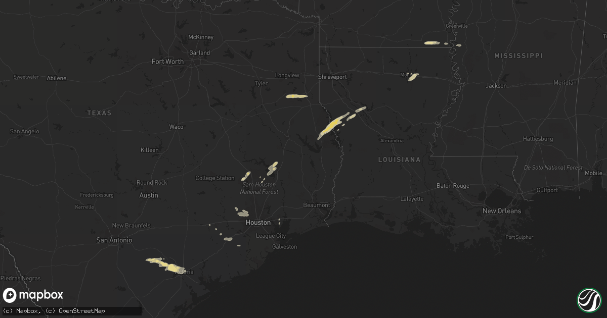
Hail Map in Louisiana on January 7, 2023
Get this storm
January 7 map
$229
one time, instant access
Download today. No call, no setup
Keep the $229
Bought the map and want the full workflow? Apply the entire $229 to a subscription within 7 days. None of it is wasted.
Every map, not just this one
This buys you this map. Subscription and you get every map we run, in the markets you choose from a few cities to whole states to nationwide. Plus real-time alerts the moment a storm fires.
Contact data
Name, contact info, occupancy, even credit band for addresses in the footprint. You go from where it hit to who to call.
Become the source they trust
Unlimited branding weather history reports on demand. You already have the documented answer ready for the property owner, and you are the one who showed up with it.
Property data and RoofTrace estimates
Pull up any address you have got, its value and the exact code rules for that jurisdiction, straight from One Click Code. Then RoofTrace estimates the squares, pitch, and roof value, priced the way you price.
Storm reports in Louisiana
Louisiana
| Date | Description |
|---|---|
| 01/07/20235:57 AM CST | At 1157 PM CST, a severe thunderstorm was located 10 miles northeast of Zwolle, or 22 miles southeast of Mansfield, moving northeast at 35 mph. HAZARD...60 mph wind gusts and nickel size hail. SOURCE...Radar indicated. IMPACT...Expect damage to roofs, siding, and trees. Locations impacted include... Natchitoches, Campti, Allen, Oak Grove, Pleasant Hill, Clarence, Ashland, Robeline, Powhatan, Lake End, Grand Ecore, Belmont, Black Lake, Marthaville, Hagewood and Ajax. |
| 01/07/20234:54 AM CST | At 1054 PM CST, a severe thunderstorm was located 9 miles west of Natchitoches, moving northeast at 25 mph. HAZARD...60 mph wind gusts and quarter size hail. SOURCE...Radar indicated. IMPACT...Hail damage to vehicles is expected. Expect wind damage to roofs, siding, and trees. Locations impacted include... Natchitoches, Campti, Allen, Natchez, Clarence, Goldonna, Calvin, Powhatan, Grand Ecore, St. Maurice, Black Lake, Chestnut, Clear Lake, Creston and Hagewood. |
| 01/07/20234:00 AM CST | At 1000 PM CST, a severe thunderstorm was located 7 miles northeast of Mansfield, moving east at 30 mph. HAZARD...60 mph wind gusts and quarter size hail. SOURCE...Radar indicated. IMPACT...Hail damage to vehicles is expected. Expect wind damage to roofs, siding, and trees. Locations impacted include... Mansfield, Coushatta, Martin, Hall Summit, Ashland, Edgefield, Womack, Carmel, Crichton, Grand Bayou and Loggy Bayou. |
| 01/07/20232:12 AM CST | At 812 PM CST, a severe thunderstorm was located near Pinehill, or 12 miles west of Carthage, moving east at 35 mph. HAZARD...60 mph wind gusts and quarter size hail. SOURCE...Radar indicated. IMPACT...Hail damage to vehicles is expected. Expect wind damage to roofs, siding, and trees. Locations impacted include... Carthage, Deberry, Pinehill, Midyett, Deadwood, Front and Fairplay. |
| 01/07/20231:17 AM CST | At 717 PM CST, a severe thunderstorm was located near Wilmot, moving east at 20 mph. HAZARD...60 mph wind gusts and quarter size hail. SOURCE...Radar indicated. IMPACT...Hail damage to vehicles is expected. Expect wind damage to roofs, siding, and trees. This severe thunderstorm will be near... Wilmot around 725 PM CST. Parkdale around 730 PM CST. Eudora around 800 PM CST.Other locations impacted by this severe thunderstorm includeKilbourne. |
| 01/06/202311:38 PM CST | Trees and power lines downed in northern sabine parish. |
| 01/06/202311:30 PM CST | Pictures of quarter-size hail posted on social media in ebarb. |
All States Impacted by Hail Map on January 7, 2023
Cities Impacted by Hail Map on January 7, 2023
- Cypress, TX
- Parkdale, AR
- Wilmot, AR
- Hamburg, AR
- Monroe, LA
- West Monroe, LA
- Hollandale, MS
- Natchitoches, LA
- Many, LA
- Carthage, TX
- Mount Enterprise, TX
- Long Branch, TX
- Henderson, TX
- Cat Spring, TX
- Alleyton, TX
- Eagle Lake, TX
- Willis, TX
- Coldspring, TX
- Cleveland, TX
- Yorktown, TX
- Baytown, TX
- Guy, TX
- Robeline, LA
- Victoria, TX
- Meyersville, TX
- Goliad, TX
- Cuero, TX
- Oak Ridge, LA
- Marthaville, LA
- New Waverly, TX
- Huntsville, TX
- Houston, TX
- San Augustine, TX
- Zwolle, LA
- Noble, LA
- Bronson, TX
- Milam, TX
- Livingston, TX
- Onalaska, TX
- Eudora, AR
- East Bernard, TX
- Belmont, LA
- Pleasant Hill, LA
- Gillett, TX
- Ecleto, TX
- Mansfield, LA
- Beasley, TX
- Hockley, TX
- Waller, TX
- Campti, LA
- Karnes City, TX
- Katy, TX
- Glen Allan, MS
- Grand Cane, LA
- Converse, LA
- Richards, TX
- Montgomery, TX


