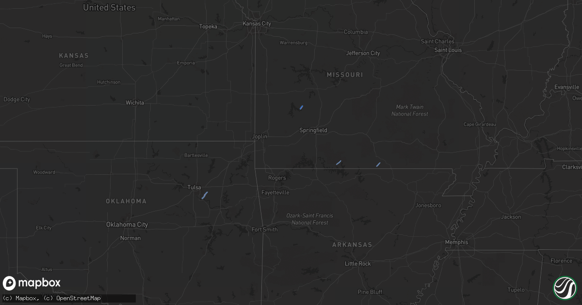
Hail Map in Missouri on December 28, 2019
Get this storm
December 28 map
$229
one time, instant access
Download today. No call, no setup
Keep the $229
Bought the map and want the full workflow? Apply the entire $229 to a subscription within 7 days. None of it is wasted.
Every map, not just this one
This buys you this map. Subscription and you get every map we run, in the markets you choose from a few cities to whole states to nationwide. Plus real-time alerts the moment a storm fires.
Contact data
Name, contact info, occupancy, even credit band for addresses in the footprint. You go from where it hit to who to call.
Become the source they trust
Unlimited branding weather history reports on demand. You already have the documented answer ready for the property owner, and you are the one who showed up with it.
Property data and RoofTrace estimates
Pull up any address you have got, its value and the exact code rules for that jurisdiction, straight from One Click Code. Then RoofTrace estimates the squares, pitch, and roof value, priced the way you price.
Storm reports in Missouri
Missouri
| Date | Description |
|---|---|
| 12/28/20194:48 AM CST | At 1047 PM CST, a severe thunderstorm was located 10 miles east of Cabool, or 10 miles north of Willow Springs, moving northeast at 55 mph. HAZARD...60 mph wind gusts. SOURCE...Radar indicated. IMPACT...Expect damage to roofs, siding, and trees. Locations impacted include... Current River State Park... Echo Bluff State Park... Ozark National Scenic Riverways... Willow Springs... Summersville... Bunker... Raymondville... Turtle... Jadwin... Howes Mill... Midridge... Arroll... Elk Creek... Gladden... Eunice... Yukon... Hartshorn... Clear Springs... Round Spring... Solo... |
| 12/28/20194:09 AM CST | At 1009 PM CST, a severe thunderstorm was located 10 miles northeast of Gainesville, or 24 miles southeast of Ava, moving northeast at 30 mph. HAZARD...60 mph wind gusts. SOURCE...Radar indicated. IMPACT...Expect damage to roofs, siding, and trees. Locations impacted include... West Plains... Willow Springs... Pomona... Siloam Springs... Brixey... Sycamore... Tecumseh... Dora... Rockbridge... Pottersville... Zanoni... |
| 12/27/201911:43 PM CST | At 543 PM CST, a severe thunderstorm was located near Nevada, moving northeast at 45 mph. HAZARD...60 mph wind gusts. SOURCE...Radar indicated. IMPACT...Expect damage to roofs, siding, and trees. Locations impacted include... Nevada... Metz... Horton... This includes Interstate 49 between mile markers 94 and 107. |
| 12/27/201911:22 PM CST | At 521 PM CST, severe thunderstorms were located along a line extending from Lee's Summit to near Harrisonville to Adrian, moving northeast at 45 mph. HAZARD...60 mph wind gusts. SOURCE...Radar indicated. IMPACT...Expect damage to roofs, siding, and trees. Locations impacted include... Lee's Summit, Raymore, Harrisonville, Pleasant Hill, Odessa, Greenwood, Holden, Garden City, Archie, Lake Winnebago, Lone Jack, East Lynne, Kingsville, Baldwin Park, Lake Lafayette, Strasburg, Gunn City, Blairstown, La Tour and Pittsville.This includes Interstate 70 in Missouri near mile marker 40. |
| 12/27/201911:05 PM CST | At 505 PM CST, severe thunderstorms were located along a line extending from 6 miles northwest of Pleasant Valley to near Sugar Creek to Belton, moving northeast at 45 mph. Isolated stronger gusts will be possible within areas of rotation along the line of storms. HAZARD...60 mph wind gusts. SOURCE...Radar indicated. IMPACT...Expect damage to roofs, siding, and trees. Locations impacted include... Kansas City, Independence, Lee's Summit, Blue Springs, Raytown, Liberty, Gladstone, Grandview, Belton, Raymore, Grain Valley, Excelsior Springs, Smithville, Kearney, Oak Grove, Greenwood, North Kansas City, Sugar Creek, Buckner and Lawson.This includes the following highways... Interstate 70 in Missouri between mile markers 4 and 29. Interstate 35 in Missouri between mile markers 5 and 30. Interstate 29 between mile markers 0 and 3. Interstate 470 between mile markers 0 and 16. Interstate 435 between mile markers 40 and 72. |
| 12/27/201911:01 PM CST | Corrects previous tstm wnd gst report from 3 e lanton. Estimated winds of 60 mph. Also some trees down in lanton. |
| 12/27/201910:54 PM CST | Corrects previous tstm wnd dmg report from 5 nnw lanton to change report source. Updates previous tstm wnd dmg report from 5 nnw lanton. Tree on car and house. Two tree |
| 12/27/201910:11 PM CST | Strong winds in gentryville and now moving into drury and vanzant in eastern douglas county fire department is est. Winds speeds 60 mph. |
| 12/27/20199:33 PM CST | Nws storm survey found damaging winds uprooted trees and possible barn damage. Winds estimated up to 80 mph. |
| 12/27/20199:32 PM CST | Emergency manager reports some minor siding damage to a barn and windows blown out of a home along county road 263. Delayed report. |
| 12/27/20199:31 PM CST | Nws storm survey determined damaging winds caused this damage: semi trailer moved 8 feet and tipped over. Trees blown over. Time based on radar. |
| 12/27/20199:29 PM CST | Report of trees down. Time based on radar. |
| 12/27/20199:25 PM CST | Nws storm survey found extensive tree damage east of rueter with winds estimated at 85 mph. Several trees were uprooted. |
| 12/27/20199:20 PM CST | Nws storm survey found tree damage south of rueter with winds estimated near 85 mph. |
| 12/27/20197:06 PM CST | End point of fair play tornado. Farm buildings damaged and trees uprooted. Tornado was on the ground for 3 minutes. |
| 12/27/20197:06 PM CST | Corrects previous tstm wnd dmg report from 2 e fair play. Mo 32 highway and s 50th rd bolivar... 3 barns significant damage. There is most of another barn on that prope |
| 12/27/20197:03 PM CST | Corrects previous tstm wnd dmg report from 2 sse fair play. Two barns destroyed and one house with roof damage. Time based on radar. |
| 12/27/20197:03 PM CST | Starting point for fair play tornado. Farm buildings damaged and trees uprooted. Tornado was on the ground for 3 minutes. |


