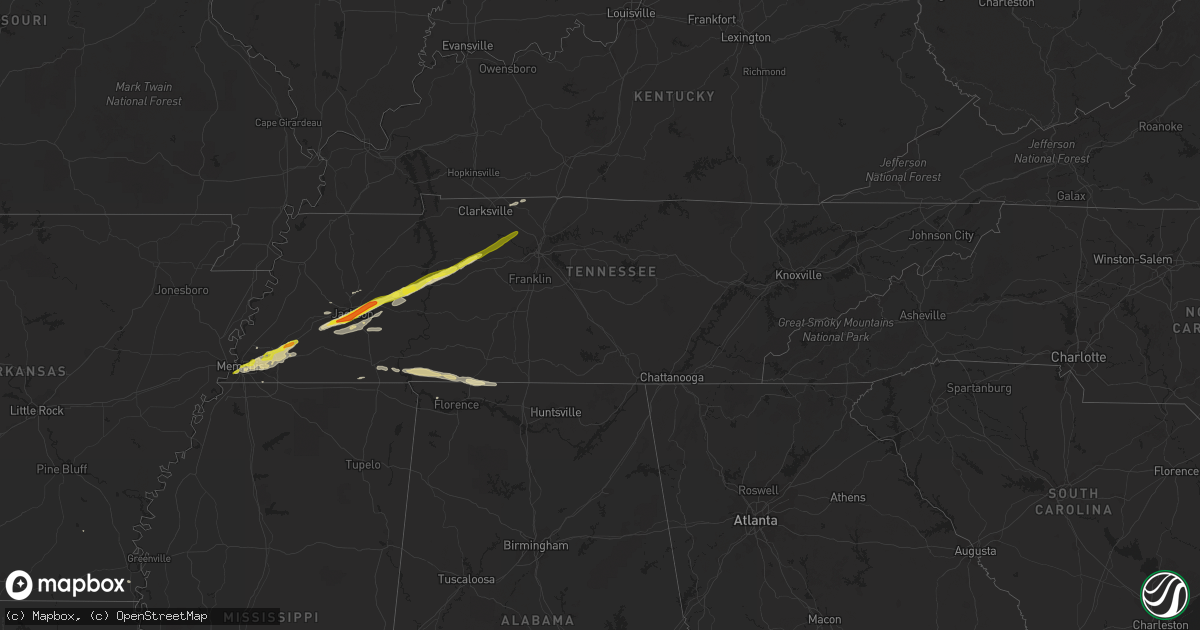
Hail Map in Tennessee on December 28, 2016
Get this storm
December 28 map
$229
one time, instant access
Download today. No call, no setup
Keep the $229
Bought the map and want the full workflow? Apply the entire $229 to a subscription within 7 days. None of it is wasted.
Every map, not just this one
This buys you this map. Subscription and you get every map we run, in the markets you choose from a few cities to whole states to nationwide. Plus real-time alerts the moment a storm fires.
Contact data
Name, contact info, occupancy, even credit band for addresses in the footprint. You go from where it hit to who to call.
Become the source they trust
Unlimited branding weather history reports on demand. You already have the documented answer ready for the property owner, and you are the one who showed up with it.
Property data and RoofTrace estimates
Pull up any address you have got, its value and the exact code rules for that jurisdiction, straight from One Click Code. Then RoofTrace estimates the squares, pitch, and roof value, priced the way you price.
Storm reports in Tennessee
Tennessee
| Date | Description |
|---|---|
| 12/28/20165:50 PM CST | Quarter size hail fell. Time estimated from radar. |
| 12/28/20165:30 PM CST | Quarter size hail fell. Time estimated from radar. |
| 12/28/20165:25 PM CST | Hail up to the size of quarters was reported. |
| 12/28/20164:25 PM CST | Ema got a report of 1 inch hail. This was not even from the strongest part of the storm. |
| 12/28/20164:07 PM CST | Quarter inch hail at intersection of mcillwain road and hwy 641. |
| 12/28/20164:07 PM CST | Quarter inch hail at intersection of mcillwain road and hwy 641. |
| 12/28/20164:07 PM CST | Quarter inch hail at intersection of mcillwain road and hwy 641. |
| 12/28/20164:00 PM CST | 1 inch hail in wildersville. |
| 12/28/20163:50 PM CST | Half dollar sized hail near blue goose. |
| 12/28/20163:38 PM CST | Several automobiles sustained hail damage on pinnacle drive near highway 70 east. |
| 12/28/20163:30 PM CST | Numerous reports of quarter to golfball sized hail in downtown jackson. |
| 12/28/20163:25 PM CST | Approximately 20 to 30 patrol cars recieved hail damage in a parking lot. Damage consisted of mostly dings and dents. No broken windows were reported. |
| 12/28/20163:24 PM CST | Golfball sized hail reported on the east side of jackson. |
| 12/28/20163:23 PM CST | Golfball sized hail reported in jackson. |
| 12/28/20163:17 PM CST | Occasional quarter sized hail falling downtown jackson around chester street. |
| 12/28/20162:25 PM CST | Quarter size hail in arlington. |
All States Impacted by Hail Map on December 28, 2016
Cities Impacted by Hail Map on December 28, 2016
- Iron City, TN
- Killen, AL
- Lexington, AL
- Saint Joseph, TN
- Lexington, TN
- Waverly, TN
- Yuma, TN
- Mercer, TN
- Huron, TN
- McEwen, TN
- Denmark, TN
- Sugar Tree, TN
- Holladay, TN
- Jackson, TN
- Brownsville, TN
- Westport, TN
- Dickson, TN
- Hurricane Mills, TN
- Wildersville, TN
- Beech Bluff, TN
- Cedar Grove, TN
- Cordova, TN
- Germantown, TN
- Somerville, TN
- Collierville, TN
- Arlington, TN
- Mason, TN
- Eads, TN
- Oakland, TN
- Memphis, TN
- Toone, TN
- Luray, TN
- Medon, TN
- Pinson, TN
- Cedar Hill, TN
- Adams, TN
- Olive Branch, MS
- Savannah, TN
- Lutts, TN
- Medina, TN
- Florence, AL
- Ramer, TN
- Pocahontas, TN
- Jacks Creek, TN
- Henderson, TN
- Springfield, TN
- Anderson, AL
- Loretto, TN
- Cypress Inn, TN
- Charleston, MS
- Drew, MS
- Selmer, TN
- Guys, TN
- Bells, TN
- Monticello, AR
- Eudora, AR
- Stanton, TN
- Darden, TN
- Whiteville, TN
- Milan, TN
- Michie, TN
- Shiloh, TN
- Counce, TN
- Millington, TN
- Ashland City, TN
- White Bluff, TN
- Charlotte, TN


