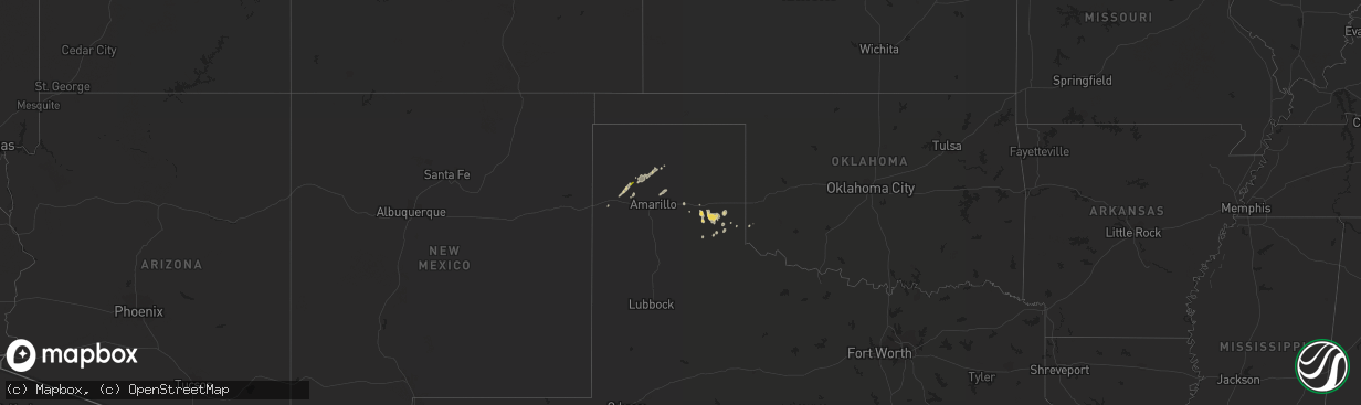
Hail Map on December 14, 2012
The weather event on December 14, 2012 includes Hail map. 2 states and 15 cities were impacted and suffered possible damage. The total estimated number of properties impacted is 67.
Want more than just the map?
Turn this storm into a full workflow.
- Owner + property data so you know who to knock
- OnDemand branded weather history reports to win the "did we even have hail?" argument
- RoofTrace estimate so reps stop guessing numbers at the door
Bought this map? Upgrade within 7 days and we'll credit the $230. (10-15 min setup call)
Hail
67
Estimated number of impacted properties by a 1.00" hail or larger0
Estimated number of impacted properties by a 1.75" hail or larger0
Estimated number of impacted properties by a 2.50" hail or largerStorm reports
New Mexico
| Date | Description |
|---|---|
| 12/14/20122:55 PM CST | Kcvn awos. |
| 12/14/20122:40 PM CST | A local report indicates 63 MPH wind near 2 SW DORA |
| 12/14/20122:30 PM CST | A local report indicates 58 MPH wind near RANCHVALE |
| 12/14/20122:27 PM CST | Kcvs asos. |
| 12/14/20122:14 PM CST | Melrose range raws. |
| 12/14/20121:45 PM CST | A local report indicates 58 MPH wind near SUMNER LAKE |
Texas
| Date | Description |
|---|---|
| 12/14/20125:55 PM CST | A local report indicates 58 MPH wind near 2 SW CANADIAN |
| 12/14/20125:34 PM CST | A fifth wheeler trailer was flipped over while being pulled by a pickup at the intersection of u.s. Highway 83 and highway 203. 8 to 12 inch diameter tree limbs down on |
| 12/14/20125:20 PM CST | A local report indicates 58 MPH wind near 1 S NORTHFIELD |
| 12/14/20125:20 PM CST | Carport damaged |
| 12/14/20124:58 PM CST | Resident reported portions of a tree...8 ft privacy fence panels...and irrigation pipe were lofted and spiraled in the air as tornado passed near her home. Witness repo |
| 12/14/20124:58 PM CST | Resident reported portions of a tree...8 ft privacy fence panels...and irrigation pipe were lofted and spiraled in the air as tornado passed near her home. Witness repo |
| 12/14/20124:53 PM CST | Damage to a metal barn and a small shed was destroyed. Rated ef0 with 80 mph winds |
| 12/14/20124:35 PM CST | A local report indicates 65 MPH wind near 1 SE RALLS |
| 12/14/20124:26 PM CST | A local report indicates 60 MPH wind near CLAUDE |
| 12/14/20124:25 PM CST | Silverton hs schoolnet |
| 12/14/20124:17 PM CST | Ef0 tornado lasted approximately 5 minutes. Spotter provided photographic evidence. |
| 12/14/20124:15 PM CST | Tornado lasted approximately 5 minutes. Spotter provided photographic evidence. |
| 12/14/20124:11 PM CST | Powerlines down near corn maze on 1294 |
| 12/14/20124:10 PM CST | Power lines are down at 15th and railroad tracks |
| 12/14/20124:10 PM CST | A local report indicates 61 MPH wind near 2 NE FRIONA |
| 12/14/20124:05 PM CST | A local report indicates 77 MPH wind near 3 WNW LUBBOCK |
| 12/14/20124:02 PM CST | A local report indicates 60 MPH wind near 3 NNW PALO DURO CANYON |
| 12/14/20124:01 PM CST | A local report indicates 61 MPH wind near 6 SW AMARILLO |
| 12/14/20124:00 PM CST | *** 1 fatal *** semi roll over at mcafee rd and washington |
| 12/14/20124:00 PM CST | Corner of metal shed roof was peeled back. |
| 12/14/20124:00 PM CST | Radio tower blown down...lying over raildroad tracks |
| 12/14/20124:00 PM CST | Damage also was reported. |
| 12/14/20123:57 PM CST | A local report indicates 64 MPH wind near 3 NW AMARILLO |
| 12/14/20123:54 PM CST | With pea sized hail |
| 12/14/20123:54 PM CST | A local report indicates 60 MPH wind near 8 ESE BUSHLAND |
| 12/14/20123:52 PM CST | Canyon junior high school |
| 12/14/20123:50 PM CST | Semi blown over on interstate 27. Time estimated from radar. |
| 12/14/20123:44 PM CST | A local report indicates 68 MPH wind near 14 SE BUFFALO LAKE |
| 12/14/20123:32 PM CST | Hart elementary schoolnet |
| 12/14/20123:32 PM CST | A couple of trucks were overturned on us highway 385. |
| 12/14/20123:30 PM CST | A local report indicates 61 MPH wind near 2 WNW HEREFORD |
| 12/14/20123:30 PM CST | A local report indicates 62 MPH wind near 4 S LEVELLAND |
| 12/14/20123:30 PM CST | Via schoolnet |
| 12/14/20123:29 PM CST | Via schoolnet |
| 12/14/20123:25 PM CST | Power lines down at 303 and 37 |
| 12/14/20123:20 PM CST | A local report indicates 74 MPH wind near 2 NE DIMMITT |
| 12/14/20123:20 PM CST | Center pivots blown over with pea size hail. Winds estimated between 60 and 70 mph |
| 12/14/20123:16 PM CST | Dimmit middle school schoolnet |
| 12/14/20123:12 PM CST | Friona high school schoolnet |
| 12/14/20123:10 PM CST | A local report indicates 58 MPH wind near 1 NE AMHERST |
| 12/14/20122:59 PM CST | Schoolnet at lazbuddie |
| 12/14/20122:50 PM CST | A local report indicates 65 MPH wind near 2 SSW MULESHOE |
Oklahoma
| Date | Description |
|---|---|
| 12/13/20127:10 PM CST | Several trees were blown down and shingles were removed from the roof of a residence. Time estimated from radar. |
| 12/13/20126:25 PM CST | Power lines downed on merritt road just north of i-40 mile marker 34 |