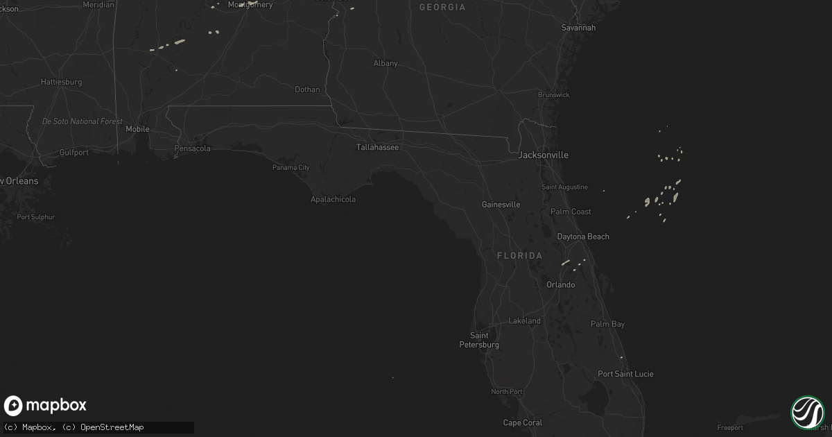
Hail Map on December 10, 2012
Get this storm
December 10 map
$229
one time, instant access
Download today. No call, no setup
Keep the $229
Bought the map and want the full workflow? Apply the entire $229 to a subscription within 7 days. None of it is wasted.
Every map, not just this one
This buys you this map. Subscription and you get every map we run, in the markets you choose from a few cities to whole states to nationwide. Plus real-time alerts the moment a storm fires.
Contact data
Name, contact info, occupancy, even credit band for addresses in the footprint. You go from where it hit to who to call.
Become the source they trust
Unlimited branding weather history reports on demand. You already have the documented answer ready for the property owner, and you are the one who showed up with it.
Property data and RoofTrace estimates
Pull up any address you have got, its value and the exact code rules for that jurisdiction, straight from One Click Code. Then RoofTrace estimates the squares, pitch, and roof value, priced the way you price.
Storm reports
Mississippi
| Date | Description |
|---|---|
| 12/10/20129:15 AM CST | Tree downed on i-59 between us 49 and hardy street |
| 12/10/20128:25 AM CST | The roof of a house was damaged near pounds rd and pickwick rd. Possible tornado. |
| 12/10/20128:19 AM CST | Survey team found an ef-1 tornado with max winds of 100 mph and a max width of 100 yds. Max path length was 3 miles. Numerous trees were snapped and uprooted along path |
| 12/10/20128:11 AM CST | Walthall county emergency manager reported structural damage to a home in dexter. |
| 12/10/20128:06 AM CST | Walthall county emergency manager reported a possible tornado along airline highway just south of highway 48. |
| 12/10/20127:57 AM CST | Nws survey confirms ef1 tornado beginning in simonds... Moving through the town of dexter and ending near mildred. Path length 20 miles with max width of 100 yards. Win |
| 12/10/20127:57 AM CST | Walthall county emergency manager reported a possible tornado along simon road in the southern part of the county near the ms/la state line. Damage to a barn and to the |
Alabama
| Date | Description |
|---|---|
| 12/10/20121:56 PM CST | One tree down across highway 49 approximately 1 mile south of the franklin community. |
| 12/10/20121:45 PM CST | Two trees and one powerline down in the town of shorter. |
| 12/10/20121:31 PM CST | A few trees down along wares ferry road. |
| 12/10/20121:22 PM CST | A tree was reported blocking brady road in pintlala. |
| 12/10/201210:36 AM CST | One tree down near newell. |
| 12/10/201210:36 AM CST | Trees were reported down on county road 62. |
| 12/10/201210:31 AM CST | 911 center reports a tree down on county road 85 just east of the i-65 overpass. |
| 12/10/201210:30 AM CST | Several trees down at the intersection of county road 62 and county road 30. |
| 12/10/201210:21 AM CST | Two trees down near fosters cross roads |
Louisiana
| Date | Description |
|---|---|
| 12/10/20129:30 AM CST | Metal roof damage at a nursery in bogalusa |
| 12/10/20128:55 AM CST | Ascension parish emergency management reported a possible tornado with damage in two areas. The first area was along black bayou road near us highway 61 and the second |
| 12/10/20128:48 AM CST | Nws survey confirms ef1 tornado beginning on u.s. Highway 61 at black bayou road to just west of oneal road. Path length is around 1.33 miles with max width of 25 yards |
| 12/10/20128:48 AM CST | Possible tornado reported by local law enforcement with damage along black bayou extention. |
| 12/10/20127:36 AM CST | Numerous trees down along cane market road in greenwell springs. |
| 12/10/20127:24 AM CST | Trees down along cell lane and state highway 1. |
| 12/10/20126:57 AM CST | Media reported a car wash destroyed along state highway 19 in baker. |
| 12/10/20126:56 AM CST | Nws survey confirms ef1 tornado beginning on u.s. Hwy 61 and ending near la hwy 67. Path length around 4 miles with max width of 100 yards. Winds estimated at 105 mph. |
| 12/10/20126:56 AM CST | Baker police department is reported widespread damage to trees and power lines across the city. Will update later with additional information as it is received. |
Florida
| Date | Description |
|---|---|
| 12/10/20124:25 PM CST | 12 mobile homes damaged and power lines down. Reports relayed from fire rescue on scene in terra mar village subdivision. Likely tornado. |
| 12/10/20123:50 PM CST | Trees were blown down about 3 miles north of hawthorne along county road 219a. |
| 12/10/20123:30 PM CST | Top of tree down. Time estimated by radar. |
| 12/10/20123:30 PM CST | Public reported tornado north of lake apopka and pictures via public and media appear to confirm waterspout over lake apopka. |
Cities Impacted by Hail Map on December 10, 2012
- Tyler, AL
- Selma, AL
- Fort Pierce, FL
- Montgomery, AL
- Douglasville, GA
- Cusseta, GA
- Pine Apple, AL
- Ochopee, FL
- Bowdon, GA
- Lagrange, GA
- Pine Mountain, GA
- Grove Hill, AL
- Geneva, FL
- Talladega, AL
- Carrollton, GA
- Tallassee, AL
- Miami, FL
- Dadeville, AL
- Sanford, FL
- Deltona, FL
- Thomasville, AL
- Dickinson, AL
- Greenville, GA
- Minter, AL
- Coy, AL
- Camden, AL