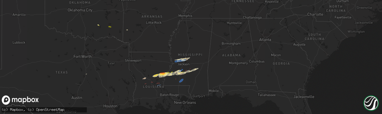
Hail Map in Mississippi on November 20, 2023
The weather event in Mississippi on November 20, 2023 includes Hail, Wind, and Tornado maps. 5 states and 78 cities were impacted and suffered possible damage. The total estimated number of properties impacted is 1,519.
Want more than just the map?
Turn this storm into a full workflow.
- Owner + property data so you know who to knock
- OnDemand branded weather history reports to win the "did we even have hail?" argument
- RoofTrace estimate so reps stop guessing numbers at the door
Bought this map? Upgrade within 7 days and we'll credit the $230. (10-15 min setup call)
Hail
Wind
Tornado
1,519
Estimated number of impacted properties by a 1.00" hail or larger0
Estimated number of impacted properties by a 1.75" hail or larger0
Estimated number of impacted properties by a 2.50" hail or largerStorm reports in Mississippi
Mississippi
| Date | Description |
|---|---|
| 11/20/20235:38 PM CST | A local report indicates 60 MPH wind near 1 NNW Gluckstadt |
| 11/20/20235:23 PM CST | A few trees were down off harris road. |
| 11/20/20234:45 PM CST | A couple trees down on oak ridge rd. |
| 11/19/20239:22 PM CST | Mobile home had porch damaged... Trees down... Metal shed damaged... Possible tornado. |
| 11/19/20238:37 PM CST | Trees down on cr 20 near cr 2012. |
| 11/19/20238:24 PM CST | Trees and power lines downed on ms 15 between bay springs and louin. |
| 11/19/20238:10 PM CST | A few trees were down or damaged along highway 37... Scr 86 and mineral springs roads. This was wind damage not associated with the center ridge tornado... But with the |
| 11/19/20237:53 PM CST | Some trees and power lines down. |
| 11/19/20237:44 PM CST | Tds noted. |
| 11/19/20237:44 PM CST | Multiple downed trees across simpson county. Report via social media. |
| 11/19/20236:43 PM CST | Tds noted along jupiter rd... Just n of hwy 28. |
| 11/19/20236:36 PM CST | Tds noted along timberlane rd. |
| 11/19/20236:36 PM CST | An nws storm survey team determined this brief tornado near highway 16 had a peak windspeed of 76 mph. It snapped one tree and uprooted another tree. |
| 11/19/20236:32 PM CST | A brief ef0 tornado touched down near williams creek in simpson county. The tornado moved northeast crossing highway 28 and moved into a wooded area north of highway 28 |
| 11/19/20236:28 PM CST | Tree and powerlines downed across ms highway 28. |
| 11/19/20236:27 PM CST | An ef1 tornado with a maximum speed of 90 mph touched down in northeastern lincoln county on the west side of lincoln lake where it snapped small trees. It tracked just |
| 11/19/20236:22 PM CST | Powerlines down near hwy 28 east of hazlehurst. |
| 11/19/20236:22 PM CST | Large trees down at bethesda rd and daniels ln. |
| 11/19/20236:22 PM CST | Metal roof blown off a building at ms 28 and bethesda rd. |
| 11/19/20236:20 PM CST | 60+ mph est gusts... Debris blowing around. |
| 11/19/20236:19 PM CST | A tree fell on a home on gallatin st. |
| 11/19/20236:19 PM CST | Minor damage to a gas station at us 51 and ms 28. |
| 11/19/20236:19 PM CST | Trees downed on magnolia st. |
| 11/19/20236:19 PM CST | Tree downed on ms highway 28 near jackson st. |
| 11/19/20236:03 PM CST | This corrects the previous tornado report from 2 wnw shoccoe. An nws storm survey team found an ef-1 rated tornado with a path length of 2.2 miles... Width of 440 yards |
| 11/19/20236:03 PM CST | Tds noted at sharon and robinson roads. |
| 11/19/20236:00 PM CST | Trees downed along ms 550. |
All States Impacted by Hail Map on November 20, 2023
Cities Impacted by Hail Map on November 20, 2023
- Iowa Park, TX
- Electra, TX
- Harrold, TX
- Elm Mott, TX
- Spiro, OK
- Provencal, LA
- Cloutierville, LA
- Lena, LA
- Coalgate, OK
- Trout, LA
- Jena, LA
- Jonesville, LA
- Snow, OK
- Nashoba, OK
- Harrisonburg, LA
- Sicily Island, LA
- Ferriday, LA
- Clayton, LA
- Waterproof, LA
- Natchez, MS
- Fayette, MS
- Lorman, MS
- Pollock, LA
- Mora, LA
- Flatwoods, LA
- Hineston, LA
- Flora, MS
- Vicksburg, MS
- Redwood, MS
- Bentonia, MS
- Bolton, MS
- Edwards, MS
- Madison, MS
- Jackson, MS
- Canton, MS
- Clinton, MS
- Pattison, MS
- Wesson, MS
- Hazlehurst, MS
- Crystal Springs, MS
- Alexandria, LA
- Pineville, LA
- Georgetown, MS
- Pinola, MS
- Braxton, MS
- Carthage, MS
- Marksville, LA
- Smithdale, MS
- Mendenhall, MS
- Moreauville, LA
- Clayton, OK
- Hermanville, MS
- Bay Springs, MS
- Mize, MS
- Taylorsville, MS
- Raleigh, MS
- Brookhaven, MS
- Union Church, MS
- Newhebron, MS
- Magee, MS
- Mount Olive, MS
- Roxie, MS
- Vidalia, LA
- Satartia, MS
- Monticello, MS
- Monterey, LA
- Mccomb, MS
- Summit, MS
- Ruth, MS
- Jayess, MS
- Tylertown, MS
- Dierks, AR
- Umpire, AR
- Louin, MS
- Paulding, MS
- Sontag, MS
- Waco, TX
- Melvin, TX


