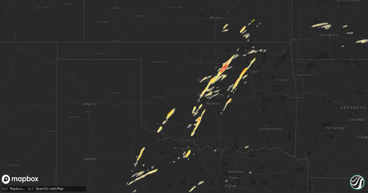
Hail Map in Oklahoma on November 19, 2025
Get this storm
November 19 map
$229
one time, instant access
Download today. No call, no setup
Keep the $229
Bought the map and want the full workflow? Apply the entire $229 to a subscription within 7 days. None of it is wasted.
Every map, not just this one
This buys you this map. Subscription and you get every map we run, in the markets you choose from a few cities to whole states to nationwide. Plus real-time alerts the moment a storm fires.
Contact data
Name, contact info, occupancy, even credit band for addresses in the footprint. You go from where it hit to who to call.
Become the source they trust
Unlimited branding weather history reports on demand. You already have the documented answer ready for the property owner, and you are the one who showed up with it.
Property data and RoofTrace estimates
Pull up any address you have got, its value and the exact code rules for that jurisdiction, straight from One Click Code. Then RoofTrace estimates the squares, pitch, and roof value, priced the way you price.
Storm reports in Oklahoma
Oklahoma
| Date | Description |
|---|---|
| 11/18/202510:10 PM CST | Social media photo from just north of morrison. |
| 11/18/202510:05 PM CST | A local report indicates 3.50 inch wind near Morrison |
| 11/18/202510:05 PM CST | Picture of tennis ball sized hail passed along by local broadcast media. |
| 11/18/202510:00 PM CST | Highway 177 and glencoe rd. |
| 11/18/20259:59 PM CST | Report from mping: ping pong ball |
| 11/18/20259:51 PM CST | A local report indicates 1.50 inch wind near 4 W Stillwater |
| 11/18/20259:50 PM CST | A local report indicates 1.75 inch wind near 3 ENE Lake Mcmurtry |
| 11/18/20259:50 PM CST | ( |
| 11/18/20259:45 PM CST | A local report indicates 1.25 inch wind near Westport |
| 11/18/20259:45 PM CST | Size estimated f |
| 11/18/20259:45 PM CST | Size estimated from photo. |
| 11/18/20259:42 PM CST | Mping report. |
| 11/18/20259:35 PM CST | Size estimated from photo. |
| 11/18/20259:34 PM CST | A local report indicates 1.00 inch wind near Mannford |
| 11/18/20259:23 PM CST | A local report indicates 1.50 inch wind near 3 SE Piedmont |
| 11/18/20259:18 PM CST | Report from mping: ping pong ball |
| 11/18/20259:04 PM CST | Mping report. |
| 11/18/20258:40 PM CST | Mping... Time estimated from radar. |
| 11/18/20258:00 PM CST | Pic from ok park/forestry partner. |
| 11/18/20257:20 PM CST | A local report indicates 2.00 inch wind near 5 NNW Marlow |
| 11/18/20257:02 PM CST | Social media pic. Time estimated. |
Cities Impacted by Hail Map on November 19, 2025
- Marana, AZ
- Tucson, AZ
- O'Brien, TX
- Knox City, TX
- Rotan, TX
- Hamlin, TX
- Laveen, AZ
- Avondale, AZ
- Garden City, TX
- Tolleson, AZ
- Phoenix, AZ
- Glendale, AZ
- Temple, OK
- Cashion, AZ
- Walters, OK
- Comanche, OK
- Aspermont, TX
- Duncan, OK
- Rule, TX
- Marlow, OK
- Byars, OK
- Westbrook, TX
- Rush Springs, OK
- Colorado City, TX
- Wanette, OK
- Olney, TX
- Haskell, TX
- Ninnekah, OK
- Bradley, OK
- Alex, OK
- Blanchard, OK
- Wichita Falls, TX
- Henrietta, TX
- Tecumseh, OK
- Shawnee, OK
- Macomb, OK
- Scotland, TX
- Anadarko, OK
- Cement, OK
- Old Glory, TX
- Tempe, AZ
- Mesa, AZ
- Roscoe, TX
- Earlsboro, OK
- Pocasset, OK
- Chickasha, OK
- Verden, OK
- Scottsdale, AZ
- Stroud, OK
- Depew, OK
- Chandler, OK
- El Reno, OK
- Union City, OK
- Oklahoma City, OK
- Sparks, OK
- Sweetwater, TX
- Bristow, OK
- Paducah, TX
- Yukon, OK
- Paden, OK
- Mustang, OK
- Edmond, OK
- Piedmont, OK
- Drumright, OK
- Lawton, OK
- Guthrie, OK
- Coyle, OK
- Burlington, OK
- Crescent, OK
- Mannford, OK
- Mulhall, OK
- Stillwater, OK
- Crowell, TX
- Seymour, TX
- Sand Springs, OK
- Jones, OK
- Spencer, OK
- Weinert, TX
- Cleveland, OK
- Prue, OK
- Glencoe, OK
- Arcadia, OK
- Luther, OK
- Morrison, OK
- Pawnee, OK
- Minco, OK
- Meeker, OK
- Amber, OK
- Skiatook, OK
- Ramona, OK
- Ralston, OK
- Perry, OK
- Orlando, OK
- Choctaw, OK
- Sperry, OK
- Davenport, OK
- Tuttle, OK
- Chillicothe, TX
- Odell, TX
- Fairfax, OK
- Elmer, OK
- Vernon, TX
- Rocksprings, TX
- Bethany, OK
- Altus, OK
- Headrick, OK
- Holliday, TX
- Grenola, KS
- Cedar Vale, KS
- Mountain Park, OK
- Roosevelt, OK
- Pawhuska, OK
- Burbank, OK
- Sedan, KS
- Archer City, TX
- Moline, KS
- Howard, KS
- Elk Falls, KS
- Winfield, KS
- Rock, KS
- Udall, KS
- Peru, KS
- Longton, KS
- Perkins, OK
- Windthorst, TX
- Hobart, OK
- Douglass, KS
- Mountain View, OK
- Gotebo, OK
- Chautauqua, KS
- Fall River, KS
- Sapulpa, OK
- Kellyville, OK
- Fredonia, KS
- Altoona, KS
- Fletcher, OK
- Prague, OK
- Harrah, OK
- Harper, TX
- Fredericksburg, TX
- Gainesville, TX
- Muenster, TX
- Kingfisher, OK
- Hennessey, OK
- Santo, TX
- Palo Pinto, TX
- Ava, MO
- Mineral Wells, TX
- Wynona, OK
- Millsap, TX
- Bartlesville, OK
- Weatherford, TX
- Poolville, TX
- Golden City, MO
- Ochelata, OK
- Irving, TX
- Vanzant, MO
- Dallas, TX
- Carrollton, TX
- Greenville, TX
- Springtown, TX
- Nowata, OK
- Willow Springs, MO
- Copan, OK
- Dewey, OK
- Delaware, OK
- Greenfield, MO
- Bokchito, OK
- Durant, OK
- Dadeville, MO
- Walnut Grove, MO
- Everton, MO
- Aldrich, MO
- Commerce, TX
- Cabool, MO
- Mountain View, MO
- Willard, MO
- Morrisville, MO
- Bolivar, MO
- Brighton, MO
- Geronimo, OK
- Pleasant Hope, MO
- Fair Grove, MO
- Springfield, MO
- Niangua, MO
- Half Way, MO
- Buffalo, MO
- Winona, MO
- Grovespring, MO
- Hartville, MO
- Mansfield, MO
- Boley, OK
- Seminole, OK


