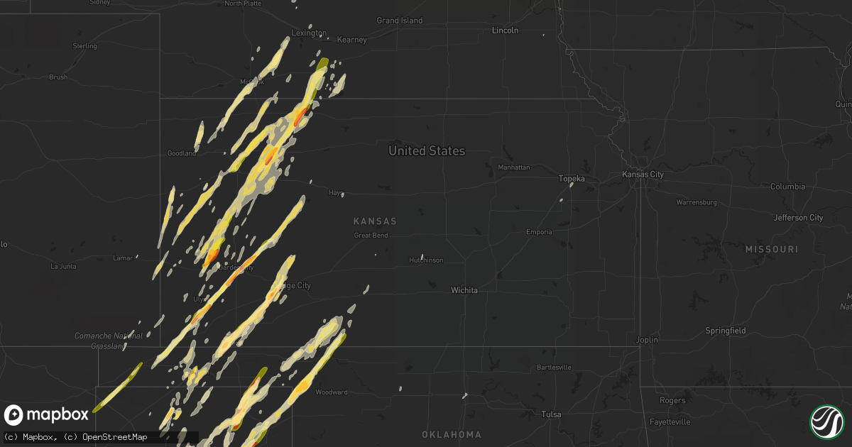
Hail Map in Kansas on November 16, 2015
Get this storm
November 16 map
$229
one time, instant access
Download today. No call, no setup
Keep the $229
Bought the map and want the full workflow? Apply the entire $229 to a subscription within 7 days. None of it is wasted.
Every map, not just this one
This buys you this map. Subscription and you get every map we run, in the markets you choose from a few cities to whole states to nationwide. Plus real-time alerts the moment a storm fires.
Contact data
Name, contact info, occupancy, even credit band for addresses in the footprint. You go from where it hit to who to call.
Become the source they trust
Unlimited branding weather history reports on demand. You already have the documented answer ready for the property owner, and you are the one who showed up with it.
Property data and RoofTrace estimates
Pull up any address you have got, its value and the exact code rules for that jurisdiction, straight from One Click Code. Then RoofTrace estimates the squares, pitch, and roof value, priced the way you price.
Storm reports in Kansas
Kansas
| Date | Description |
|---|---|
| 11/16/20155:59 PM CST | A local report indicates 1.75 inch wind near 1 WNW TASCO |
| 11/16/20155:55 PM CST | Time is approximate/based on radar. Power lines blown down... Damage done to grain bins... And damage to the home there. |
| 11/16/20155:54 PM CST | A local report indicates 1.00 inch wind near 1 NNW OAKLEY |
| 11/16/20155:47 PM CST | Debris were reported in the air. |
| 11/16/20155:45 PM CST | A local report indicates 1.75 inch wind near 8 W LIBERAL |
| 11/16/20155:43 PM CST | Law enforcement report of tornado. Power lines down along k-23. |
| 11/16/20155:38 PM CST | Tornado reported in grainfield with damage to numerous trees. Power lines down... Windows broken and sheds destroyed. |
| 11/16/20155:37 PM CST | A local report indicates 1.00 inch wind near LIBERAL |
| 11/16/20155:31 PM CST | Tornado on the ground 1mi south of i-70. |
| 11/16/20155:25 PM CST | Near zero visibility in rain and blowing dirt also reported |
| 11/16/20155:20 PM CST | Small tornado on the ground. |
| 11/16/20155:19 PM CST | A local report indicates a tornado near 11 N PIERCEVILLE |
| 11/16/20155:17 PM CST | A brief dusty tornado was observed. |
| 11/16/20155:05 PM CST | Significant hail swath with numerous golfball to 2 inch diameter hail stones... Which caused vehicle damage including a cracked windshield. |
| 11/16/20154:55 PM CST | Late report from november 16 2015. Davis wx station. |
| 11/16/20154:17 PM CST | A local report indicates 1.00 inch wind near 6 NE MODOC |
| 11/16/20154:00 PM CST | Dime to quarter size hail covering the ground. |
| 11/16/20153:54 PM CST | A local report indicates a tornado near 8 S ULYSSES |
| 11/16/20153:52 PM CST | A local report indicates 1.00 inch wind near 13 WSW FRIEND |
| 11/16/20153:28 PM CST | Hail varied from the size of quarters to golfballs. |
| 11/16/20153:27 PM CST | A local report indicates 1.00 inch wind near 7 N ROLLA |
| 11/16/20153:05 PM CST | A local report indicates 1.00 inch wind near ELKHART |
| 11/16/20151:40 AM CST | Delayed report of shed damage due to large uprooted tree along with windows blown out at the residence. |
| 11/16/201512:53 AM CST | A local report indicates 64 MPH wind near 7 SSW ANTHONY |
| 11/15/201511:15 PM CST | 10 power poles were down along highway 160 |
| 11/15/201511:11 PM CST | A local report indicates 1.00 inch wind near COLDWATER |
| 11/15/201510:37 PM CST | 2 homes damaged |
| 11/15/201510:25 PM CST | Three sheds were destroyed... Including a full size farm shed. |
| 11/15/201510:20 PM CST | 2 homes damaged |
| 11/15/20159:30 PM CST | A local report indicates 62 MPH wind near 2 WNW FT. DODGE |
| 11/15/20158:46 PM CST | Roof blown off of the town power plant. Shed blown off its foundation and landed on a car. Numerous tree limbs broken off. Damage looked to be confined to the southeast |
| 11/15/20158:45 PM CST | A local report indicates 60 MPH wind near 2 SW PLAINS CITY |
| 11/15/20158:25 PM CST | A local report indicates 60 MPH wind near 6 SSE COLLYER |
| 11/15/20158:20 PM CST | A quonset structure was heavily damaged. The location is estimated and time is based on radar. |
| 11/15/20157:50 PM CST | Power lines down across county road. |
| 11/15/20157:42 PM CST | A local report indicates 1.50 inch wind near HOXIE |
| 11/15/20157:39 PM CST | Law enforcement and a fire unit reported two brief rope tornadoes. |
| 11/15/20157:32 PM CST | Em reported power lines down at 19 road and highway 56. |
| 11/15/20157:12 PM CST | A local report indicates 1.00 inch wind near NORTON |
| 11/15/20157:11 PM CST | A residence was damaged... And power lines are down. |
| 11/15/20157:06 PM CST | Law enforcement reports a tornado just south of tasco... Location radar estimated. Residence and outbuildings are damaged. |
| 11/15/20157:05 PM CST | A local report indicates a tornado near 3 NNE ENSIGN |
| 11/15/20156:57 PM CST | Emergency manager reporting power poles snapped off and power lines across the road at hh road between road 15 and 16. |
| 11/15/20156:55 PM CST | A local report indicates 1.75 inch wind near 6 S NORTON |
| 11/15/20156:53 PM CST | A local report indicates 1.75 inch wind near 3 WNW THE HAGGARD ELEV |
| 11/15/20156:45 PM CST | 17 to 18 power poles report down on p road and 250 road |
| 11/15/20156:45 PM CST | Significant damage to a barn reported. |
| 11/15/20156:45 PM CST | Windows and garage doors blown out/damaged at the coop. Similar damage and other minor building damage also occurred in the town. |
| 11/15/20156:44 PM CST | A local report indicates a tornado near 2 W RANSOM |
| 11/15/20156:43 PM CST | Law enforcement report of tornado. Power lines down along k-23. |
| 11/15/20156:42 PM CST | A local report indicates 1.00 inch wind near 1 WNW THE HAGGARD ELEV |
| 11/15/20156:40 PM CST | Power poles reported down east of p road and highway 147. |
| 11/15/20156:32 PM CST | Em reported power lines down at 19 road and highway 56. |
| 11/15/20156:30 PM CST | Damage to at least one residence... Hog farms and power lines was reported from the tornado that passed through the area. |
| 11/15/20156:29 PM CST | A large tornado continues and is very well defined from observers. |
| 11/15/20156:20 PM CST | Emergency manager reporting power poles snapped off and power lines across the road at hh road between road 15 and 16. |
| 11/15/20156:13 PM CST | Quarter sized hail is covering the ground. |
| 11/15/20156:07 PM CST | Chaser estimated a quarter mile wide tornado |
All States Impacted by Hail Map on November 16, 2015
Cities Impacted by Hail Map on November 16, 2015
- Amarillo, TX
- Canyon, TX
- Guymon, OK
- Wayside, TX
- Tulia, TX
- Claude, TX
- Happy, TX
- Dresden, KS
- Pampa, TX
- Lakin, KS
- Comstock, NE
- Norton, KS
- Cimarron, KS
- Colorado City, TX
- Liberal, KS
- Hugoton, KS
- Monahans, TX
- Beeler, KS
- Dighton, KS
- Perryton, TX
- Ulysses, KS
- Crowell, TX
- Grainfield, KS
- Utica, KS
- Ness City, KS
- Ransom, KS
- Garden City, KS
- Andrews, TX
- Jetmore, KS
- Hawley, TX
- Merkel, TX
- Abilene, TX
- Albany, TX
- Lueders, TX
- Culbertson, NE
- Eustis, NE
- Moorefield, NE
- Indianola, NE
- Stockville, NE
- Seymour, TX
- Hoxie, KS
- Seminole, TX
- Seagraves, TX
- Selden, KS
- Atwood, KS
- Gem, KS
- Oberlin, KS
- Rexford, KS
- Colby, KS
- Strawn, TX
- Texline, TX
- Dalhart, TX
- Felt, OK
- Boise City, OK
- Munday, TX
- Coldwater, KS
- Freedom, OK
- Buffalo, OK
- Panhandle, TX
- Stinnett, TX
- Masterson, TX
- Fritch, TX
- Borger, TX
- Sunray, TX
- Farnam, NE
- Bartley, NE
- Baird, TX
- Elkhart, KS
- Walsh, CO
- Weskan, KS
- Haskell, TX
- Rochester, TX
- Henrietta, TX
- Wichita Falls, TX
- Holly, CO
- Long Island, KS
- Stamford, NE
- Winona, KS
- Laverne, OK
- Gate, OK
- Rosston, OK
- Hydro, OK
- Corn, OK
- Weatherford, OK
- Ensign, KS
- Fowler, KS
- Dodge City, KS
- Alma, NE
- Orleans, NE
- Deerfield, KS
- Aspermont, TX
- Snyder, TX
- Jayton, TX
- Big Lake, TX
- Dumas, TX
- Wellington, TX
- Quail, TX
- Memphis, TX
- Frederick, OK
- Stratford, TX
- Callaway, NE
- Indiahoma, OK
- Oxford, NE
- Atlanta, NE
- Syracuse, KS
- Monument, KS
- Wallace, KS
- Lenora, KS
- Gove, KS
- Oakley, KS
- Park, KS
- Marienthal, KS
- Norcatur, KS
- Morland, KS
- Scott City, KS
- Hill City, KS
- Holdrege, NE
- Jennings, KS
- Tribune, KS
- Quinter, KS
- Penokee, KS
- Almena, KS
- Grinnell, KS
- Clayton, KS
- Leoti, KS
- Healy, KS
- Beaver City, NE
- Richfield, KS
- Goodwell, OK
- Gould, OK
- Protection, KS
- Breckenridge, TX
- Moran, TX
- Caddo, TX
- Cisco, TX
- Miami, TX
- McDonald, KS
- Skellytown, TX
- Sargent, NE
- McCook, NE
- Levant, KS
- Post, TX
- Lorenzo, TX
- Ralls, TX
- Wilson, TX
- Slaton, TX
- Tahoka, TX
- Wilmore, KS
- Rolla, KS
- Satanta, KS
- Goldsmith, TX
- Kermit, TX
- Westbrook, TX
- Cactus, TX
- Keyes, OK
- Wakeeney, KS
- Trent, TX
- Sweetwater, TX
- Campo, CO
- Booker, TX
- Spearman, TX
- Balko, OK
- Tyrone, OK
- Montezuma, KS
- Hooker, OK
- Plains, KS
- Kismet, KS
- Meade, KS
- Holcomb, KS
- Groom, TX
- Follett, TX
- Canadian, TX
- Shattuck, OK
- May, OK
- Higgins, TX
- Lipscomb, TX
- Fargo, OK
- Gruver, TX
- Herndon, KS
- Ludell, KS
- Altus, OK
- Garden City, TX
- Hays, KS
- Victoria, KS
- Otoe, NE
- Avoca, NE
- Graford, TX
- Clyde, TX
- Sharon Springs, KS
- Coolidge, KS
- Vernon, TX
- Elm Creek, NE
- Goree, TX
- Throckmorton, TX
- Weinert, TX
- Berryton, KS
- Topeka, KS
- Wilson, OK
- Edson, KS
- Bird City, KS
- Childress, TX
- Haviland, KS
- Chillicothe, TX
- Tipton, OK
- Perry, OK
- Lebanon, NE
- Wilsonville, NE
- Pratt, KS
- Ashland, KS
- Floydada, TX
- Duncan, OK
- Odessa, TX
- Crane, TX
- Bertrand, NE
- Kiron, IA
- Ogallah, KS
- Ellis, KS
- Brewster, KS
- Stanton, NE
- Harrold, TX
- White Deer, TX
- Big Spring, TX
- Wildorado, TX
- Oklaunion, TX
- El Reno, OK
- Electra, TX
- Buffalo Gap, TX
- Tuscola, TX
- Elmer, OK
- Odell, TX
- Cambridge, NE
- Holbrook, NE
- Overton, NE
- St John, KS
- Turkey, TX
- Sterling City, TX
- Mangum, OK
- Rule, TX
- Republican City, NE
- Lawton, OK
- Johnson, KS
- Elk City, OK
- Portsmouth, IA
- Roscoe, TX
- Loraine, TX
- Tye, TX
- Dyess Afb, TX
- Anson, TX
- Maryneal, TX
- Tyndall, SD
- Tabor, SD
- Scotland, SD
- Quanah, TX
- Atkinson, NE
- Holliday, TX
- Maywood, NE
- Pacific Junction, IA
- Hardesty, OK
- Elgin, OK
- Clarendon, TX
- Burlingame, KS
- Eddyville, NE
- Lexington, NE
- Olton, TX
- Apache, OK
- Cyril, OK
- Comanche, OK
- Sylvester, TX
- Wilcox, NE
- Clinton, OK
- Lamar, CO
- Hutchinson, KS
- Shamrock, TX
- Turpin, OK
- Collyer, KS
- Moscow, KS
- Hart, TX
- Roby, TX
- Inman, NE
- Ringwood, OK
- Helena, OK
- Lockney, TX
- Davidson, OK
- Granite, OK
- Gracemont, OK
- Fort Cobb, OK
- Texhoma, OK
- Sentinel, OK
- Cordell, OK
- Curtis, NE
- Nazareth, TX
- Kress, TX
- Dill City, OK
- Colony, OK
- Beaver, OK
- Sedan, NM
- Loomis, NE


