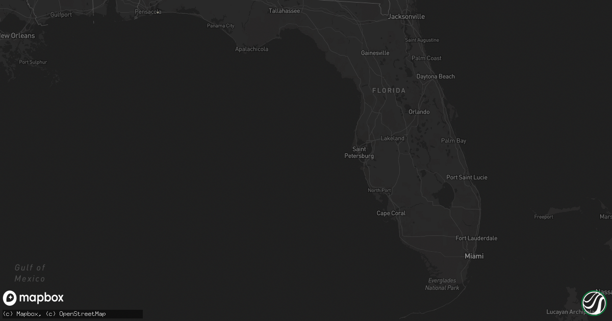
Hail Map in Florida on November 12, 2018
Get this storm
November 12 map
$229
one time, instant access
Download today. No call, no setup
Keep the $229
Bought the map and want the full workflow? Apply the entire $229 to a subscription within 7 days. None of it is wasted.
Every map, not just this one
This buys you this map. Subscription and you get every map we run, in the markets you choose from a few cities to whole states to nationwide. Plus real-time alerts the moment a storm fires.
Contact data
Name, contact info, occupancy, even credit band for addresses in the footprint. You go from where it hit to who to call.
Become the source they trust
Unlimited branding weather history reports on demand. You already have the documented answer ready for the property owner, and you are the one who showed up with it.
Property data and RoofTrace estimates
Pull up any address you have got, its value and the exact code rules for that jurisdiction, straight from One Click Code. Then RoofTrace estimates the squares, pitch, and roof value, priced the way you price.
Storm reports in Florida
Florida
| Date | Description |
|---|---|
| 11/12/201811:35 AM CST | Online public report that a neighborhood playground was torn from ground and blown approx 100 feet. Time estimated from radar. |
| 11/12/201811:35 AM CST | Sheriffs office reported tree limbs and powerlines down near the corner of east bay blvd and gulf breeze parkway. Time estimated from radar. |
| 11/12/201811:35 AM CST | Trained storm spotter called-in to report cloud rotation with wind rotation at the surface near the corner of east bay blvd and gulf breeze parkway. Two cars had to com |
| 11/12/20185:59 AM CST | At 1158 AM CST, a severe thunderstorm was located 7 miles north of Navarre, or 9 miles southeast of Bagdad, moving northeast at 30 mph. This severe thunderstorm does still contain rotation, so a tornado could form with little or no advanced warning. HAZARD...60 mph wind gusts. SOURCE...Radar indicated. IMPACT...Expect damage to roofs, siding, and trees. Locations impacted include... Crestview and Baker. |
| 11/12/20182:56 AM CST | At 854 AM CST, a severe thunderstorm was located 6 miles southwest of Pensacola Beach, or 7 miles south of Gulf Breeze, moving northeast at 25 mph. A tornado could form with little or no advanced warning. HAZARD...60 mph wind gusts and penny size hail. SOURCE...Radar indicated. IMPACT...Expect damage to roofs, siding, and trees. Locations impacted include... Pensacola, Gulf Breeze, Oriole Beach and Pensacola Beach. |
| 11/11/20189:26 PM CST | At 325 PM CST, severe thunderstorms were located along a line extending from near Wright to Ocean City to near Fort Walton Beach to 5 miles south of Cinco Bayou to 13 miles southwest of Destin to 16 miles south of Mary Esther, moving northeast at 40 mph. HAZARD...60 mph wind gusts. SOURCE...Radar indicated. IMPACT...Expect damage to roofs, siding, and trees. Locations impacted include... Wright, Fort Walton Beach, Niceville, Destin, Eglin AFB, Valparaiso, Mary Esther, Ocean City, Lake Lorraine, Shalimar, Cinco Bayou and Eglin Air Force Base. |
| 11/11/20188:16 PM CST | At 215 PM EST/115 PM CST/, a severe thunderstorm was located 7 miles south of Tyndall Air Force Base, or 14 miles south of Callaway, moving northeast at 20 mph. HAZARD...60 mph wind gusts. SOURCE...Radar indicated. IMPACT...Expect damage to roofs, siding, and trees. Locations impacted include... Callaway, Mexico Beach, Tyndall Air Force Base, Parker, Overstreet, Davis Beach, Allanton, Wetappo and Beacon Hill. |
| 11/11/20188:16 PM CST | At 216 PM CST, a severe thunderstorm was located 8 miles southeast of Panama City Beach, moving northeast at 20 mph. HAZARD...60 mph wind gusts. SOURCE...Radar indicated. IMPACT...Expect damage to roofs, siding, and trees. Locations impacted include... Panama City, Lynn Haven, Panama City Beach, Springfield, Hiland Park, Tyndall Air Force Base, St Andrews State Park, Gulf Lagoon Beach, Magnolia Beach, Cedar Grove, Dirego Park, Biltmore Beach and Millville. |


