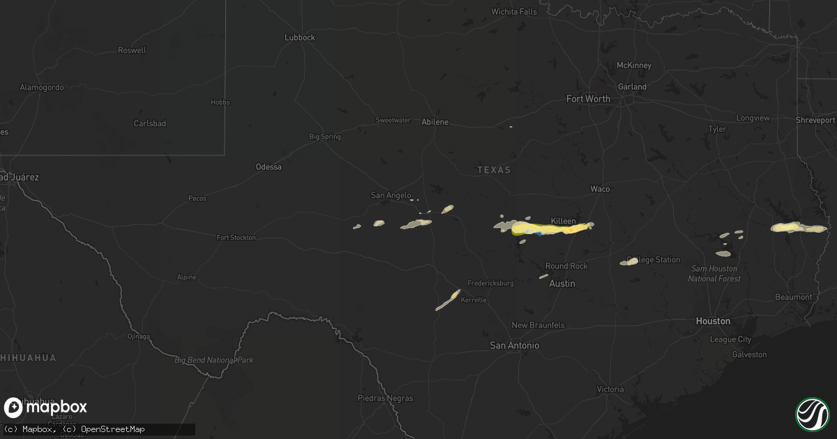
Hail Map in Texas on November 11, 2022
Get this storm
November 11 map
$229
one time, instant access
Download today. No call, no setup
Keep the $229
Bought the map and want the full workflow? Apply the entire $229 to a subscription within 7 days. None of it is wasted.
Every map, not just this one
This buys you this map. Subscription and you get every map we run, in the markets you choose from a few cities to whole states to nationwide. Plus real-time alerts the moment a storm fires.
Contact data
Name, contact info, occupancy, even credit band for addresses in the footprint. You go from where it hit to who to call.
Become the source they trust
Unlimited branding weather history reports on demand. You already have the documented answer ready for the property owner, and you are the one who showed up with it.
Property data and RoofTrace estimates
Pull up any address you have got, its value and the exact code rules for that jurisdiction, straight from One Click Code. Then RoofTrace estimates the squares, pitch, and roof value, priced the way you price.
Storm reports in Texas
Texas
| Date | Description |
|---|---|
| 11/11/20225:00 PM CST | Trees down around the town. |
| 11/11/20229:42 AM CST | 2 inch hail reported with a cracked windshield of a car and 50 mph est. Winds. |
| 11/11/20229:35 AM CST | Report from mping: quarter |
| 11/11/20229:35 AM CST | A local report indicates 1.00 inch wind near 2 S BELTON |
| 11/11/20229:25 AM CST | Golf ball size hail reported between harker heights and salado on 2484 1 mile west of 1620. |
| 11/11/20229:22 AM CST | Social media reported hail up to half dollar in killeen. |
| 11/11/20229:17 AM CST | Mping report of half-dollar sized hail. |
| 11/11/20229:05 AM CST | Quarter sized hail reported by a cocorahs spotter near kempner. |
| 11/11/20229:00 AM CST | Reports of quarter to half-dollar sized hail... With some pea size hail mixed in too. |
| 11/11/20228:55 AM CST | Public report of dime to quarter sized hail in oakalla near the intersection of fm 963 and fm 2657. |
| 11/11/20224:08 AM CST | At 1007 PM CST, a severe thunderstorm was located over Mission, moving southeast at 20 mph. HAZARD...60 mph wind gusts and quarter size hail. SOURCE...Radar indicated. IMPACT...Hail damage to vehicles is expected. Expect wind damage to roofs, siding, and trees. Locations impacted include... Mission, Pharr, Weslaco, San Juan, Alamo, Donna, Hidalgo, Palmview, Palmhurst and North McAllen. |
| 11/11/20223:12 AM CST | At 912 AM CST, a severe thunderstorm was located 7 miles south of Killeen, moving east at 50 mph. HAZARD...Half dollar size hail. SOURCE...Radar indicated. IMPACT...Damage to vehicles is possible. Locations impacted include... Killeen, Temple, Harker Heights, Belton, Fort Hood, Nolanville, Morgan's Point Resort, Bartlett, Salado, Little River-Academy, Rogers, Holland, Buckholts, Belton Lake, Stillhouse Hollow Lake, Sparks, Union Grove, Ding Dong, Yarrelton and Maxdale.This includes Interstate 35 between mile markers 278 and 304. |
| 11/11/20223:01 AM CST | At 901 AM CST, a severe thunderstorm was located near Briggs, or 10 miles south of Copperas Cove, moving east at 55 mph. HAZARD...60 mph wind gusts and quarter size hail. SOURCE...Radar indicated. IMPACT...Hail damage to vehicles is expected. Expect wind damage to roofs, siding, and trees. Locations impacted include... Burnet, Jarrell, Florence, Lake Victor, Mahomet, Sunnylane, Joppa, Watson, Andice, Briggs, Shady Grove and Schwertner. |
| 11/11/20222:34 AM CST | At 834 AM CST, a severe thunderstorm was located 8 miles southwest of Lampasas, moving east at 60 mph. HAZARD...60 mph wind gusts and quarter size hail. SOURCE...Radar indicated. IMPACT...Hail damage to vehicles is expected. Expect wind damage to roofs, siding, and trees. Locations impacted include... Sunnylane, Lake Victor and Watson. |
| 11/11/20222:33 AM CST | At 833 AM CST, a severe thunderstorm was located 7 miles west of Lampasas, moving east at 45 mph. HAZARD...Quarter size hail. SOURCE...Radar indicated. IMPACT...Damage to vehicles is possible. Locations impacted include... Killeen, Copperas Cove, Harker Heights, Lampasas, Fort Hood, Nolanville, Kempner, Stillhouse Hollow Lake, Ding Dong, Maxdale, Cedar Valley, Rumley, Youngsport, Topsey and Nix. |
| 11/11/20221:41 AM CST | At 740 PM CST, a severe thunderstorm was located 12 miles north of Riviera Beach, or 15 miles east of Kingsville, moving southeast at 25 mph. HAZARD...60 mph wind gusts and quarter size hail. SOURCE...Radar indicated. IMPACT...Hail damage to vehicles is expected. Expect wind damage to roofs, siding, and trees. Locations impacted include... Kingsville, Malaquite Beach and Kingsville Naval Air Station. |
| 11/11/202212:26 AM CST | At 626 PM CST, severe thunderstorms were located along a line extending from near Tulla to near Singer to Oretta to near De Quincy to 6 miles south of Fields to near Lunita, moving east at 45 mph. HAZARD...60 mph wind gusts and penny size hail. SOURCE...Radar indicated. IMPACT...Expect damage to roofs, siding, and trees. Locations impacted include... De Ridder, Reeves, Dry Creek, Singer, Fields, Sugartown, De Quincy, Mittie, Ragley, Grant, Longville, Buller, Topsy, Gillis, Tulla, Oretta and Bundick Lake. |
| 11/10/202210:28 PM CST | A thunderstorm wind gust of 59 mph was observed at the mfe asos at 1028 pm. |
Cities Impacted by Hail Map on November 11, 2022
- Temple, TX
- San Saba, TX
- Leander, TX
- Spicewood, TX
- Austin, TX
- Pointblank, TX
- Colmesneil, TX
- Jasper, TX
- Leakey, TX
- Hunt, TX
- Brookeland, TX
- Chester, TX
- Zavalla, TX
- Burkeville, TX
- Wiergate, TX
- Newton, TX
- Menard, TX
- Caldwell, TX
- Mcallen, TX
- Mission, TX
- Kingsville, TX
- Eden, TX
- Cherokee, TX
- Burnet, TX
- Mountain Home, TX
- Ingram, TX
- Salado, TX
- Killeen, TX
- Belton, TX
- Melvin, TX
- Lohn, TX
- Lampasas, TX
- Kempner, TX
- Briggs, TX
- Lometa, TX
- Bend, TX
- Harker Heights, TX
- Hidalgo, TX
- Eldorado, TX
- Christoval, TX
- Groveton, TX
- Trinity, TX
- Ozona, TX
- Eola, TX
- Moscow, TX
- Corrigan, TX
- Paint Rock, TX
- Coldspring, TX
- Oakhurst, TX
- Livingston, TX
- Ranger, TX
- Chesterfield, VA
- Richmond, VA
- Chester, VA
- Hanover, VA
- Henrico, VA
- Mechanicsville, VA
- Tappahannock, VA
- Aylett, VA
- Saint Stephens Church, VA
- Manquin, VA
- Newtown, VA


