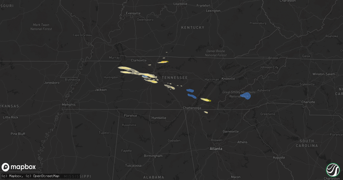
Hail Map in Tennessee on November 7, 2025
Get this storm
November 7 map
$229
one time, instant access
Download today. No call, no setup
Keep the $229
Bought the map and want the full workflow? Apply the entire $229 to a subscription within 7 days. None of it is wasted.
Every map, not just this one
This buys you this map. Subscription and you get every map we run, in the markets you choose from a few cities to whole states to nationwide. Plus real-time alerts the moment a storm fires.
Contact data
Name, contact info, occupancy, even credit band for addresses in the footprint. You go from where it hit to who to call.
Become the source they trust
Unlimited branding weather history reports on demand. You already have the documented answer ready for the property owner, and you are the one who showed up with it.
Property data and RoofTrace estimates
Pull up any address you have got, its value and the exact code rules for that jurisdiction, straight from One Click Code. Then RoofTrace estimates the squares, pitch, and roof value, priced the way you price.
Storm reports in Tennessee
Tennessee
| Date | Description |
|---|---|
| 11/07/20254:43 PM CST | Delayed report. Tree reported down on a house on arrowhead drive in brentwood. Time estimated from radar. |
| 11/07/20254:32 PM CST | Delayed report. 8-10 trees were reported broken or uprooted on chapel court and brookside drive. One home had minor damage where a tree fell on it and broke the wooden |
| 11/07/20254:31 PM CST | Trees down near hwy 431 southeast of bellevue. |
| 11/07/20254:26 PM CST | 60+ mph winds reported in bellevue by broadcast media and storm chasers. Trees reported down in the area. |
| 11/07/20254:26 PM CST | 60+ mph win |
| 11/07/20254:26 PM CST | 60+ mph winds reported in bellevue by broadcast media and storm chasers. Trees reported dow |
| 11/07/20254:24 PM CST | Report from mping: quarter |
| 11/07/20254:23 PM CST | Report from mping: quarter |
| 11/07/20254:05 PM CST | Numerous trees down across montgomery bell state park. Some roads are closed. |
| 11/07/20253:50 PM CST | A tree blown onto a house on w 1st st in dickson. |
| 11/07/20252:56 PM CST | A brief microburst caused damage to tree limbs... Uprooted a tree... And damaged a barn along cedar grove rd and hollands road. Small hail also occurred. |
All States Impacted by Hail Map on November 7, 2025
Cities Impacted by Hail Map on November 7, 2025
- Springville, TN
- Big Sandy, TN
- Stewart, TN
- Eva, TN
- Waverly, TN
- Tennessee Ridge, TN
- McEwen, TN
- Erin, TN
- Dickson, TN
- Vanleer, TN
- Charlotte, TN
- Kingston Springs, TN
- Fairview, TN
- Pegram, TN
- Burns, TN
- White Bluff, TN
- Nashville, TN
- Brentwood, TN
- Franklin, TN
- Scottsville, KY
- Pleasant View, TN
- Ashland City, TN
- Joelton, TN
- Springfield, TN
- Greenbrier, TN
- Cottontown, TN
- White House, TN
- Hendersonville, TN
- Gallatin, TN
- Portland, TN
- Bethpage, TN
- Castalian Springs, TN
- Westmoreland, TN
- Bon Aqua, TN
- Antioch, TN
- Nolensville, TN
- College Grove, TN
- Thompsons Station, TN
- Arrington, TN
- Mcminnville, TN
- Smyrna, TN
- Spencer, TN
- Pikeville, TN
- Readyville, TN
- Murfreesboro, TN
- Christiana, TN
- Bradyville, TN
- Beechgrove, TN
- Woodbury, TN
- Morrison, TN
- Manchester, TN
- Rock Island, TN
- Dunlap, TN
- Palmer, TN
- Graysville, TN
- Soddy Daisy, TN
- Sale Creek, TN
- Georgetown, TN
- Birchwood, TN
- Charleston, TN
- Cleveland, TN
- Calhoun, TN
- Riceville, TN
- Delano, TN
- Bryson City, NC
- Whittier, NC
- Cherokee, NC
- Sylva, NC
- Maggie Valley, NC
- Cullowhee, NC
- Waynesville, NC
- Balsam, NC
- Crandall, GA
- Chatsworth, GA
- Dalton, GA
- Cisco, GA


