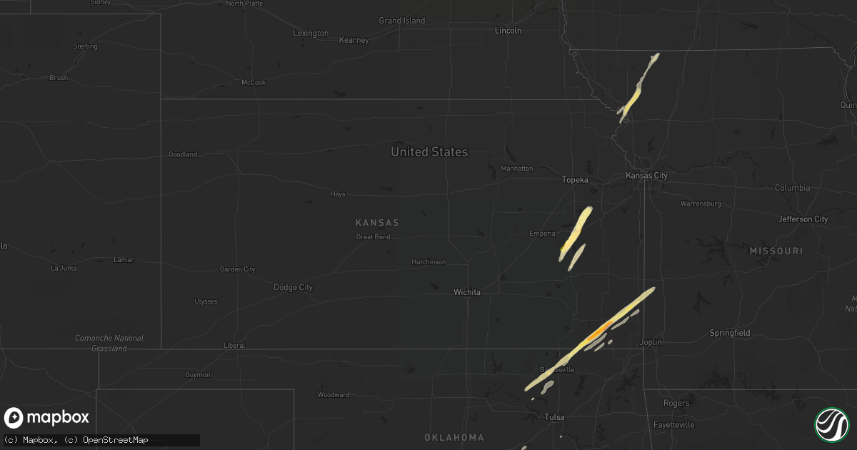
Hail Map in Kansas on November 5, 2015
Get this storm
November 5 map
$229
one time, instant access
Download today. No call, no setup
Keep the $229
Bought the map and want the full workflow? Apply the entire $229 to a subscription within 7 days. None of it is wasted.
Every map, not just this one
This buys you this map. Subscription and you get every map we run, in the markets you choose from a few cities to whole states to nationwide. Plus real-time alerts the moment a storm fires.
Contact data
Name, contact info, occupancy, even credit band for addresses in the footprint. You go from where it hit to who to call.
Become the source they trust
Unlimited branding weather history reports on demand. You already have the documented answer ready for the property owner, and you are the one who showed up with it.
Property data and RoofTrace estimates
Pull up any address you have got, its value and the exact code rules for that jurisdiction, straight from One Click Code. Then RoofTrace estimates the squares, pitch, and roof value, priced the way you price.
Storm reports in Kansas
Kansas
| Date | Description |
|---|---|
| 11/05/20152:00 PM CST | A local report indicates 1.00 inch wind near MELVERN |
| 11/05/20151:40 PM CST | A local report indicates 1.50 inch wind near 5 NNW BURLINGTON |
| 11/05/20151:20 PM CST | Based on multiple videos and eyewitness accounts of an emergency management official...a microburst produced damage across the town of girard. Several trees were downed |
| 11/05/20151:20 PM CST | Quarter hail reported at natures corner preschool. |
| 11/05/20151:16 PM CST | A local report indicates 1.00 inch wind near 5 SE GREENBUSH |
| 11/05/201512:45 PM CST | Quarter to golfball size. Lots of quarter size. |
| 11/05/201512:24 PM CST | Reported in town. |
Cities Impacted by Hail Map on November 5, 2015
- Burneyville, OK
- Decatur, TX
- Wathena, KS
- Valley View, TX
- Gainesville, TX
- Sherman, TX
- Ponder, TX
- Justin, TX
- Bixby, OK
- Jacksboro, TX
- Perrin, TX
- Leon, OK
- Marietta, OK
- Wilson, OK
- Overbrook, OK
- Saint Jo, TX
- Mcloud, OK
- Harrah, OK
- Newalla, OK
- Era, TX
- Minco, OK
- Stanberry, MO
- Conception, MO
- Bowie, TX
- Bellevue, TX
- Whitesboro, TX
- Howe, TX
- Alvord, TX
- Pottsboro, TX
- Denison, TX
- Collinsville, TX
- Sanger, TX
- Kingston, OK
- Gordonville, TX
- Sadler, TX
- Wichita Falls, TX
- Melvern, KS
- Lyndon, KS
- Quenemo, KS
- Pomona, KS
- Edna, KS
- Altamont, KS
- Mound Valley, KS
- Parsons, KS
- Coffeyville, KS
- McCune, KS
- Oswego, KS
- Liberty, KS
- Denton, TX
- Krum, TX
- Boyd, TX
- Springtown, TX
- Bridgeport, TX
- Poolville, TX
- Rhome, TX
- Whitt, TX
- Paradise, TX
- Mill Creek, OK
- Tishomingo, OK
- Bennington, OK
- Nocona, TX
- Ringgold, TX
- Ringling, OK
- Stamford, TX
- Avoca, TX
- Holliday, TX
- Windthorst, TX
- Olney, TX
- Newcastle, TX
- Overbrook, KS
- Gridley, KS
- Burlington, KS
- Lebo, KS
- Vassar, KS
- Waverly, KS
- Arcadia, KS
- Mulberry, KS
- Barnsdall, OK
- Lenapah, OK
- S Coffeyville, OK
- Dewey, OK
- Wann, OK
- Delaware, OK
- Arma, KS
- Pawhuska, OK
- Moundville, MO
- Bartlesville, OK
- Liberal, MO
- Franklin, KS
- Bronaugh, MO
- Farlington, KS
- Wynona, OK
- Girard, KS
- Rea, MO
- Rosendale, MO
- Savannah, MO
- Westphalia, KS
- Le Roy, KS
- Yates Center, KS
- Bolckow, MO
- Amazonia, MO
- Guilford, MO
- Saint Joseph, MO
- Bartlett, KS
- Welch, OK
- Lindsay, OK
- Choctaw, OK
- Ryan, OK
- Palo Pinto, TX
- Graford, TX
- Ardmore, OK
- Henrietta, TX
- Newcastle, OK
- Blanchard, OK
- Norman, OK
- Oxford, IA
- Throckmorton, TX
- Bells, TX
- Woodson, TX
- Milburn, OK
- Strawn, TX
- Atoka, OK
- Coleman, OK
- Okmulgee, OK
- Duncan, OK
- Loco, OK
- Wayne, OK
- Byars, OK
- Hominy, OK
- Madill, OK
- Paoli, OK
- Pauls Valley, OK
- Wanette, OK
- Maysville, OK
- Lexington, OK
- Talihina, OK
- Mustang, OK
- Tuttle, OK
- Union City, OK
- Macomb, OK
- Oklahoma City, OK
- Cherokee, KS
- Caddo, OK
- Caney, OK
- Bokchito, OK
- Comanche, OK
- Chetopa, KS
- Waurika, OK
- Sulphur, OK
- Davis, OK
- Stonewall, OK
- Walters, OK
- Tupelo, OK
- Worth, MO
- Grant City, MO
- Sheridan, MO
- Montague, TX
- Seymour, TX
- Gentry, MO
- Troy, KS
- Ravenwood, MO
- Clyde, MO
- Albany, TX
- Bryson, TX
- Jermyn, TX
- Meeker, OK
- Chandler, OK
- Aubrey, TX
- Mineral Wells, TX
- Pilot Point, TX
- Celina, TX
- Weatherford, TX
- Chico, TX
- Fletcher, OK
- Heavener, OK
- Wister, OK
- Seminole, OK
- Savoy, TX
- Pittsburg, KS
- Saint Paul, KS
- Petrolia, TX
- Muenster, TX
- Scurry, TX
- Kemp, TX
- Saint Charles, IA
- New Virginia, IA
- Foster, OK
- Elmore City, OK
- Frontenac, KS
- Purcell, OK
- Amber, OK
- Okemah, OK
- Whitewright, TX
- Indianola, IA
- Prole, IA
- Depew, OK
- Bristow, OK
- Wynnewood, OK
- Ratliff City, OK
- Graham, OK
- Springer, OK
- Hennepin, OK
- Healdton, OK
- Yukon, OK
- El Reno, OK


