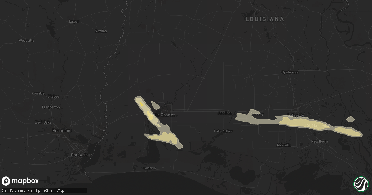
Hail Map in Lake Charles, LA on November 5, 2012
Get this storm
November 5 map
$229
one time, instant access
Download today. No call, no setup
Keep the $229
Bought the map and want the full workflow? Apply the entire $229 to a subscription within 7 days. None of it is wasted.
Every map, not just this one
This buys you this map. Subscription and you get every map we run, in the markets you choose from a few cities to whole states to nationwide. Plus real-time alerts the moment a storm fires.
Contact data
Name, contact info, occupancy, even credit band for addresses in the footprint. You go from where it hit to who to call.
Become the source they trust
Unlimited branding weather history reports on demand. You already have the documented answer ready for the property owner, and you are the one who showed up with it.
Property data and RoofTrace estimates
Pull up any address you have got, its value and the exact code rules for that jurisdiction, straight from One Click Code. Then RoofTrace estimates the squares, pitch, and roof value, priced the way you price.
Storm reports in Lake Charles, LA
Lake Charles, LA
| Date | Description |
|---|---|
| 11/05/20125:51 PM CST | Nws employee reports a tree uprooted on country club rd near albertsons in lake charles. Tree is leaning on a nearby building |
| 11/05/20125:42 PM CST | Public reports quarter size hail and power outages on big lake rd in lake charles |
| 11/05/20125:42 PM CST | Lake charles asos measured a wind gust of 69 mph. |
| 11/05/20125:40 PM CST | Nws employee reports quarter to half dollar size hail at the corner of nelson rd and country club rd in lake charles. Trees partially stripped of leaves. |
| 11/05/20125:37 PM CST | Public reports quarter to half dollar size hail via the submit a storm report program. |
| 11/05/20125:36 PM CST | Nws employee reports quarter size hail in lake charles |
| 11/05/20125:36 PM CST | Nws employee reports estimated wind gusts of 50-60 mph in lake charles |
| 11/05/20125:35 PM CST | Nws volunteer reported quarter size hail at the corner of lake st and country club rd in lake charles |
| 11/05/20125:29 PM CST | Lake charles fire department reports quarter size hail on hwy 27 and houston river rd. |
All States Impacted by Hail Map on November 5, 2012
All Cities Impacted by Hail Map on November 5, 2012
- Call, TX
- Kirbyville, TX
- Greenwell Springs, LA
- Denham Springs, LA
- Walker, LA
- Singer, LA
- Dequincy, LA
- Bon Wier, TX
- Merryville, LA
- Starks, LA
- Silsbee, TX
- Baton Rouge, LA
- Springfield, LA
- Broussard, LA
- Youngsville, LA
- Maurice, LA
- Rayne, LA
- Saint Martinville, LA
- Duson, LA
- Crowley, LA
- Lafayette, LA
- Morse, LA
- Estherwood, LA
- Bismarck, AR
- Malvern, AR
- Splendora, TX
- Cleveland, TX
- Dayton, TX
- Loreauville, LA
- Jeanerette, LA
- Saint Bernard, LA
- Clute, TX
- Angleton, TX
- Freeport, TX
- Egan, LA
- New Iberia, LA
- Lucedale, MS
- Manvel, TX
- Fresno, TX
- Rosharon, TX
- Slaughter, LA
- Zachary, LA
- Newton, TX
- Anahuac, TX
- Liberty, TX
- Cameron, LA
- Creole, LA
- White Castle, LA
- Plaquemine, LA
- Westlake, LA
- Sulphur, LA
- Lake Charles, LA
- Bell City, LA
- Galveston, TX
- Jasper, TX
- Pride, LA
- Ethel, LA
- Hackberry, LA
- New Ulm, TX
- Cat Spring, TX
- Donaldson, AR
- Sunshine, LA
- Wallisville, TX
- Lake Jackson, TX


