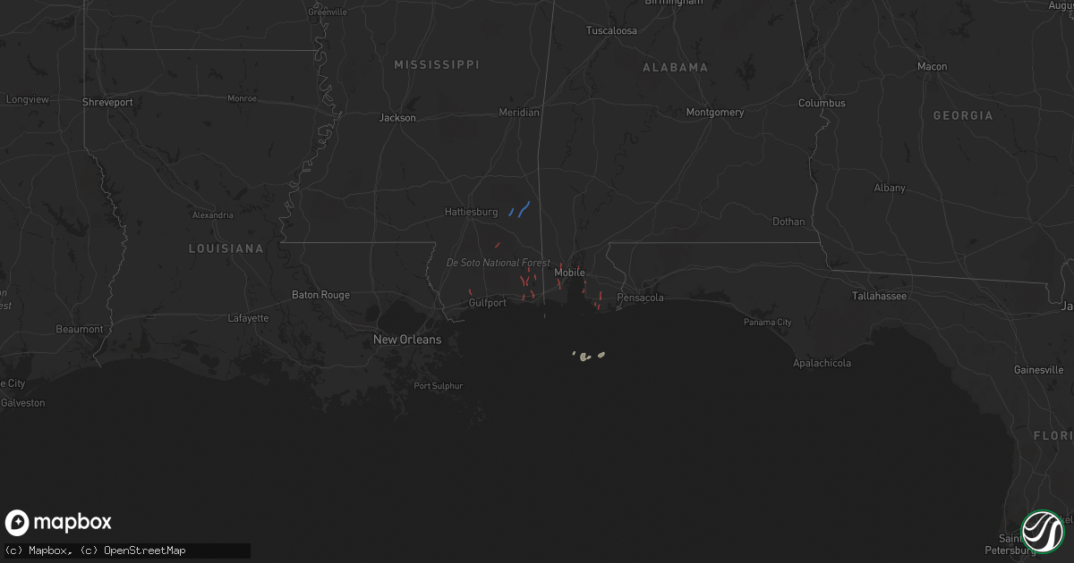
Hail Map on October 29, 2022
Get this storm
October 29 map
$229
one time, instant access
Download today. No call, no setup
Keep the $229
Bought the map and want the full workflow? Apply the entire $229 to a subscription within 7 days. None of it is wasted.
Every map, not just this one
This buys you this map. Subscription and you get every map we run, in the markets you choose from a few cities to whole states to nationwide. Plus real-time alerts the moment a storm fires.
Contact data
Name, contact info, occupancy, even credit band for addresses in the footprint. You go from where it hit to who to call.
Become the source they trust
Unlimited branding weather history reports on demand. You already have the documented answer ready for the property owner, and you are the one who showed up with it.
Property data and RoofTrace estimates
Pull up any address you have got, its value and the exact code rules for that jurisdiction, straight from One Click Code. Then RoofTrace estimates the squares, pitch, and roof value, priced the way you price.
States Impacted by Hail Map on October 29, 2022
Storm reports
Alabama
| Date | Description |
|---|---|
| 10/29/20226:03 PM CDT | Video of tornado on broadcast media northwest of spanish fort. |
| 10/29/20225:17 PM CDT | Numerous damage reports around magnolia springs of trees and power lines down. First responders report visual and touchdown. |
| 10/29/20225:03 PM CDT | 911 reports damage to a house near tung ave due to a possible tornado. |
| 10/29/20223:16 AM CDT | At 816 PM CDT, a severe thunderstorm was located near State Line, or 14 miles west of Chatom, moving northeast at 25 mph. HAZARD...60 mph wind gusts. SOURCE...Radar indicated. IMPACT...Expect damage to roofs, siding, and trees. Locations impacted include... Millry and Buckatunna. |
| 10/28/20227:02 PM CDT | Social media photos of damage in bon secour due to possible tornado. |
Mississippi
| Date | Description |
|---|---|
| 10/29/20225:35 PM CDT | Trees reported snapped at lum cumbest park in hurley... Ms. Time estimated by radar. |
| 10/29/20225:30 PM CDT | Video of tornado on the ground relayed to nws by storm chaser. |
| 10/29/20225:27 PM CDT | An nws storm survey team found damage consistent with an ef-1 tornado in jackson county... Ms. The tornado touched down at the soccer fields at lum cumbest park... Wher |
| 10/29/20224:45 PM CDT | Video of a tornado touching down in an open field about 3 miles north of wade along ms highway 63. |
| 10/29/20223:30 PM CDT | Home reported damaged. |
| 10/29/20223:28 PM CDT | Update to previous report based on survey. Brief tornado touched down near river walk dr and river place dr. Most significant damage noted near east end of polly lake r |
| 10/29/20223:25 PM CDT | Em watched tornado touch down in marshy area north of downtown moss point east of hwy 513. Also received public report of vehicle and building damage near i-10. |
| 10/29/20223:20 PM CDT | An nws storm survey of the moss point tornado found damage representative of an ef-1. The tornado touched near grierson st and hwy 63 in jackson county... Ms... Where i |
| 10/29/20223:00 PM CDT | Damage reported to the roof of school. Trees also broken and twisted. |
| 10/29/20222:52 PM CDT | Corrects previous tornado report. Section of roof collapsed on gautier middle school. No observed damage to any surrounding trees or buildings in the area. May have bee |
| 10/29/202212:37 PM CDT | Update to previous report based on storm survey. Small awning similar to a gas station awning was lifted from the ground and thrown into nearby power lines. Weight of t |
| 10/29/202212:32 PM CDT | Awning blown off of necos market. Also... A few power poles downed. Time estimated from radar. Possible tornado. |
| 10/29/20222:37 AM CDT | At 737 PM CDT, a severe thunderstorm was located 11 miles northwest of Leakesville, moving northeast at 20 mph. HAZARD...60 mph wind gusts. SOURCE...Radar indicated. IMPACT...Expect damage to roofs, siding, and trees. Locations impacted include... State Line, Buckatunna and Fruitdale. |
| 10/29/20221:34 AM CDT | At 633 PM CDT, a severe thunderstorm was located 5 miles southeast of Richton, moving northeast at 65 mph. HAZARD...60 mph wind gusts. SOURCE...Radar indicated. IMPACT...Expect damage to roofs, siding, and trees. Locations impacted include... Richton. |
| 10/29/202212:59 AM CDT | At 558 PM CDT, a severe thunderstorm was located 4 miles southwest of McLain, or 19 miles south of Richton, moving northeast at 25 mph. HAZARD...60 mph wind gusts. SOURCE...Radar indicated. IMPACT...Expect damage to roofs, siding, and trees. Locations impacted include... Beaumont and McLain. |
| 10/28/20229:52 PM CDT | At 252 PM CDT, a severe thunderstorm was located over Gautier, or near Moss Point, moving north at 25 mph. HAZARD...60 mph wind gusts. SOURCE...Radar indicated. IMPACT...Expect damage to roofs, siding, and trees. Locations impacted include... Moss Point, Escatawpa, Gautier, Vancleave, Hickory Hills and Helena.This includes Interstate 10 in Mississippi between mile markers 57and 72. |