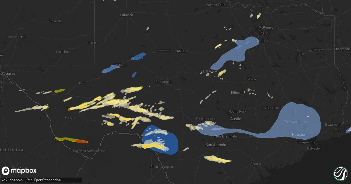
Hail Map in Texas on October 24, 2025
Get this storm
October 24 map
$229
one time, instant access
Download today. No call, no setup
Keep the $229
Bought the map and want the full workflow? Apply the entire $229 to a subscription within 7 days. None of it is wasted.
Every map, not just this one
This buys you this map. Subscription and you get every map we run, in the markets you choose from a few cities to whole states to nationwide. Plus real-time alerts the moment a storm fires.
Contact data
Name, contact info, occupancy, even credit band for addresses in the footprint. You go from where it hit to who to call.
Become the source they trust
Unlimited branding weather history reports on demand. You already have the documented answer ready for the property owner, and you are the one who showed up with it.
Property data and RoofTrace estimates
Pull up any address you have got, its value and the exact code rules for that jurisdiction, straight from One Click Code. Then RoofTrace estimates the squares, pitch, and roof value, priced the way you price.
Storm reports in Texas
Texas
| Date | Description |
|---|---|
| 10/24/20256:54 PM CDT | A local report indicates 1.00 inch wind near 5 SW Amarillo |
| 10/24/20256:46 PM CDT | Vis social media. |
| 10/24/20255:04 PM CDT | [landspout] third and final landspout observed near dimmitt for two minutes. |
| 10/24/20254:50 PM CDT | [landspout] occurred simultaneously with earlier landspout. This lasted for 12 minutes. |
| 10/24/20254:40 PM CDT | Presidio county so relayed a report of quarter sized hail at the port of entry in presidio. Time estimated from radar. |
| 10/24/20254:30 PM CDT | [landspout] first of three landspouts near dimmitt. This lasted for 20 minutes. |
| 10/24/20254:25 PM CDT | Reagan county so reports half dollar size hail in big lake. |
| 10/24/20253:45 PM CDT | [landspout] |
| 10/24/20253:05 PM CDT | Pecos county emergency management reports golf ball sized hail in fort stockton near everts st and railroad ave and and near state hwy 18 and 45 lane. |
| 10/24/20253:01 PM CDT | Pecos county emergency management reports quarter sized hail in fort stockton. |
| 10/24/20252:15 PM CDT | Awos station kbpg big spring. |
| 10/24/20251:50 PM CDT | Corrects previous non-tstm wnd gst report from 5 sw saint lawrence. Mesonet station 55 5sw st. Lawrence... Tx. |
| 10/24/20251:29 PM CDT | Asos station kmaf midland intl air and space port recorded a wind gust of 58 mph. |
| 10/24/20251:21 PM CDT | Asos station kodo odessa. |
| 10/24/20256:13 AM CDT | Severe thunderstorm wind gusts knocked down a tree limb into a power line causing a transformer fire. |
| 10/24/20256:13 AM CDT | Se |
| 10/24/20254:33 AM CDT | Downed tree limbs located at the intersection of kingwood dr. And forest shores dr. In kingwood... Tx. |
| 10/24/20254:24 AM CDT | Small accumulation of pea to quarter size hail in pleasanton. |
| 10/24/20253:55 AM CDT | Awos station kmcj ho |
| 10/24/20253:55 AM CDT | Awos station kmcj houston univ measured a 59 mph wind gust. |
| 10/24/20253:54 AM CDT | Asos station khou houston hobby. |
| 10/24/20253:45 AM CDT | Fallen trees knock down power line on cr 388 near fm 2025 in cleveland... Tx. |
| 10/24/20253:24 AM CDT | Debris and downed power lines near rayford and geneva rd. |
| 10/24/20253:15 AM CDT | Downed trees and power line along martin luther king dr. And 7th st. In huntsville... Tx. |
| 10/24/20253:13 AM CDT | Structure damage from downed tree along tafelski rd near sh 75 in new waverly... Tx. |
| 10/24/20253:10 AM CDT | Downed fences in the northern point subdivision in tomball... Tx. |
| 10/24/20253:06 AM CDT | Corrects previous tstm wnd dmg report from 6 ne montgomery. Debris and downed power lines along fm 1097 and bentwater dr. In willis... Tx. |
| 10/24/20253:00 AM CDT | Debris and downed power lines along fm 1097 and bentwater dr. In willis... Tx. |
| 10/24/20252:49 AM CDT | Storm chaser posted on social media... Reporting 60 mph winds in waller county. |
| 10/24/20252:44 AM CDT | Structural damage due to downed tree along diemer road in pattison... Tx. |
| 10/24/20252:38 AM CDT | Downed trees blocking roadway at the intersection of clark rd. And oakbourne rd. |
| 10/24/20252:38 AM CDT | Mesonet station 030hc 4650 hwy 6 at sh290 measured a 64 mph wind gust. |
| 10/24/20252:30 AM CDT | Reports of debris and downed trees in the city of sealy along fowlkes st.... As well as in briarwood estates. |
| 10/24/20252:15 AM CDT | Awos station k66r columbus measured a 63 mph wind gust. |
| 10/24/20252:06 AM CDT | Large tree down in at the intersection of fm 50and cr 390 in independence... Tx. |
| 10/24/202512:01 AM CDT | Corrects previous non-tstm wnd gst report from 3 e canyon lake. Mesonet station ew4792 canyon lake. |
| 10/24/202512:01 AM CDT | Metal sheeting peeled off of a vacation home. Time approximated based on radar. |
| 10/24/202512:00 AM CDT | Damage with possible roof off a structure reported on the 800 block of sundown trail near fischer. Possible tornado. Em relayed via scanner. Time estimated via radar. |
| 10/23/202511:51 PM CDT | Trees down and power lost in the cascada subdivision via social media; possible tornado... Time estimated via radar. |
| 10/23/202511:46 PM CDT | Downed powerlines near hwy 281 and fm 306. Possible tornado. Em relayed via scanner. Time estimated via radar. |
| 10/23/202511:10 PM CDT | Metal roofing and solar panels torn off of home. Time approximated based on radar. |
| 10/23/20259:10 PM CDT | Wind gust measured by the west texas mesonet site in comstock. Time is approximate. |
| 10/23/20259:08 PM CDT | Large tree blown down. Time estimated. |
| 10/23/20259:08 PM CDT | Knfw. |
| 10/23/20259:05 PM CDT | Mesonet station twb46 1.8 e devils river state natural area - del norte |
| 10/23/20259:02 PM CDT | A local report indicates 67 MPH wind near 2 NNE Kennedale |
| 10/23/20258:55 PM CDT | Mesonet station twb08 10.5 ne juno |
| 10/23/20258:00 PM CDT | Emergency manager reported several trees uprooted along campus drive and i-20 near the resource connection building at tcc south campus in fort worth. |
| 10/23/20258:00 PM CDT | A resident of this area reported some tree branches down in this neighborhood... Along with a couple of trees down. |
| 10/23/20257:58 PM CDT | Delayed report. Snapped power pole... Many feet up. |
| 10/23/20257:57 PM CDT | Delayed report. Several snapped branches in this city park. |
| 10/23/20257:40 PM CDT | Mostly peas with a few nickels to quarter size hailstones. |
| 10/23/20257:34 PM CDT | Ksep. |
All States Impacted by Hail Map on October 24, 2025
Cities Impacted by Hail Map on October 24, 2025
- Fort Hancock, TX
- Sierra Blanca, TX
- Van Horn, TX
- Valentine, TX
- Marfa, TX
- Alpine, TX
- Fort Stockton, TX
- Crane, TX
- Ozona, TX
- Fort Davis, TX
- Odessa, TX
- Goldsmith, TX
- Justiceburg, TX
- Snyder, TX
- Iraan, TX
- Midland, TX
- Big Spring, TX
- Westbrook, TX
- Coahoma, TX
- Garden City, TX
- Big Lake, TX
- Paducah, TX
- Imperial, TX
- Mertzon, TX
- Amorita, OK
- Burlington, OK
- Muleshoe, TX
- Midkiff, TX
- Anthony, KS
- Waldron, KS
- Sudan, TX
- Erick, OK
- San Angelo, TX
- Earth, TX
- Amherst, TX
- Barnhart, TX
- Presidio, TX
- Shamrock, TX
- Littlefield, TX
- Sheffield, TX
- Jacksboro, TX
- Strawn, TX
- Ranger, TX
- Dryden, TX
- Gladstone, NM
- Gage, OK
- Brownwood, TX
- Gordon, TX
- Mosquero, NM
- Fargo, OK
- Bridgeport, TX
- Perrin, TX
- Palo Pinto, TX
- Mineral Wells, TX
- Blanket, TX
- Zephyr, TX
- Marathon, TX
- Amarillo, TX
- Canyon, TX
- Comanche, TX
- Eldorado, TX
- Sonora, TX
- Gustine, TX
- Gainesville, TX
- Valley View, TX
- Comstock, TX
- Tioga, TX
- Collinsville, TX
- Carlton, TX
- Hamilton, TX
- Pottsville, TX
- Weatherford, TX
- Dublin, TX
- De Leon, TX
- Stephenville, TX
- Hico, TX
- Bluff Dale, TX
- Glen Rose, TX
- Tolar, TX
- Mingus, TX
- Whitesboro, TX
- Sanderson, TX
- Art, TX
- San Saba, TX
- Valley Spring, TX
- Cherokee, TX
- Goldthwaite, TX
- Evant, TX
- Lometa, TX
- Bend, TX
- Pontotoc, TX
- Granbury, TX
- Nemo, TX
- Rainbow, TX
- Cleburne, TX
- Lipan, TX
- Aledo, TX
- Fort Worth, TX
- Godley, TX
- Joshua, TX
- Cresson, TX
- Burleson, TX
- Crowley, TX
- Walnut Springs, TX
- Rocksprings, TX
- Naval Air Station Jrb, TX
- Kopperl, TX
- Morgan, TX
- Blum, TX
- Rio Vista, TX
- Mansfield, TX
- Haltom City, TX
- Kennedale, TX
- Meridian, TX
- Del Rio, TX
- Arlington, TX
- Venus, TX
- Hurst, TX
- North Richland Hills, TX
- Midlothian, TX
- Grand Prairie, TX
- Red Oak, TX
- Cedar Hill, TX
- Waxahachie, TX
- Clifton, TX
- Junction, TX
- Dallas, TX
- Duncanville, TX
- Bedford, TX
- Colleyville, TX
- Grapevine, TX
- Euless, TX
- Brackettville, TX
- Laughlin Afb, TX
- Barksdale, TX
- Tucumcari, NM
- Temple, TX
- Mountain Home, TX
- Hunt, TX
- Mcalister, NM
- Ingram, TX
- Troy, TX
- Eddy, TX
- Lott, TX
- Kerrville, TX
- Medina, TX
- Irving, TX
- Comfort, TX
- Rosebud, TX
- Center Point, TX
- Melrose, NM
- Fredericksburg, TX
- Stonewall, TX
- Boerne, TX
- Blanco, TX
- Uvalde, TX
- Camp Wood, TX
- Bandera, TX
- Pipe Creek, TX
- Portales, NM
- Franklin, TX
- Bulverde, TX
- San Antonio, TX
- Bergheim, TX
- Spring Branch, TX
- Kendalia, TX
- New Braunfels, TX
- Canyon Lake, TX
- San Marcos, TX
- Fischer, TX
- Maxwell, TX
- Martindale, TX
- Lockhart, TX
- Kyle, TX
- Dale, TX
- Rosanky, TX
- Red Rock, TX
- Flatonia, TX
- Waelder, TX
- Muldoon, TX
- Schulenburg, TX
- Weimar, TX
- Rogers, NM
- Columbus, TX
- Alleyton, TX
- Glidden, TX
- New Ulm, TX
- Cat Spring, TX
- Sealy, TX
- Bellville, TX
- Brookshire, TX
- Katy, TX
- Hempstead, TX
- Chappell Hill, TX
- Waller, TX
- Prairie View, TX
- Navasota, TX
- Hockley, TX
- Eagle Lake, TX
- Wallis, TX
- Fulshear, TX
- Richmond, TX
- Washington, TX
- Anderson, TX
- Iola, TX
- Bedias, TX
- Plantersville, TX
- Richards, TX
- North Zulch, TX
- Madisonville, TX
- Montgomery, TX
- Magnolia, TX
- Huntsville, TX
- Cypress, TX
- Tomball, TX
- Pinehurst, TX
- Houston, TX
- Brenham, TX
- New Waverly, TX
- Conroe, TX
- Willis, TX
- Spring, TX
- Sugar Land, TX
- Stafford, TX
- Humble, TX
- Bigfoot, TX
- Moore, TX
- Bellaire, TX
- Galena Park, TX
- Pasadena, TX
- Webster, TX
- South Houston, TX
- New Caney, TX
- Kingwood, TX
- Porter, TX
- Cleveland, TX
- Splendora, TX
- Channelview, TX
- Huffman, TX
- Dayton, TX
- Coldspring, TX
- Shepherd, TX
- Pointblank, TX
- Oakhurst, TX
- Livingston, TX
- Goodrich, TX
- Charlotte, TX
- Poteet, TX
- Saratoga, TX
- Crosby, TX
- Liberty, TX
- La Porte, TX
- Baytown, TX
- Highlands, TX
- Deer Park, TX
- Seabrook, TX
- Hull, TX
- Jourdanton, TX
- Pleasanton, TX
- Falls City, TX
- Floresville, TX
- Wallisville, TX
- Anahuac, TX
- Batson, TX
- Hankamer, TX
- Devers, TX
- Campbellton, TX
- Karnes City, TX
- Hobson, TX
- Sabinal, TX
- Knippa, TX
- D Hanis, TX
- Cameron, LA
- Hackberry, LA
- Wimberley, TX


