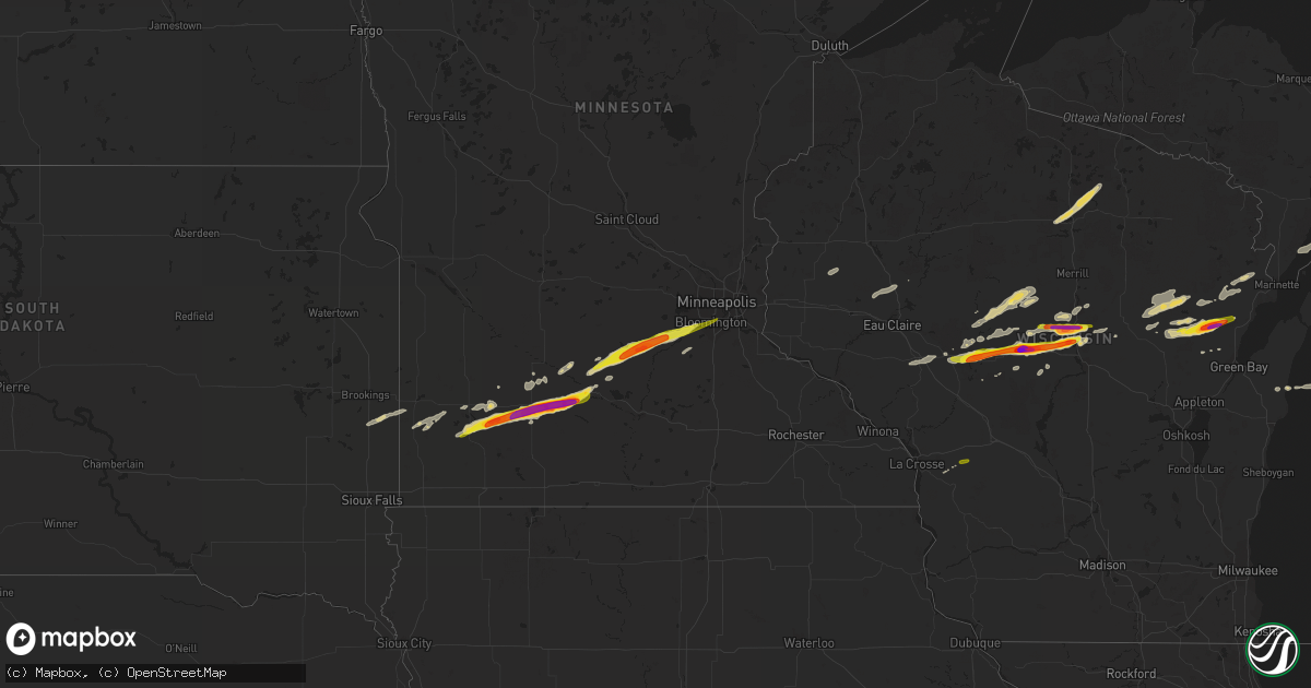
Hail Map on October 24, 2023
Get this storm
October 24 map
$229
one time, instant access
Download today. No call, no setup
Keep the $229
Bought the map and want the full workflow? Apply the entire $229 to a subscription within 7 days. None of it is wasted.
Every map, not just this one
This buys you this map. Subscription and you get every map we run, in the markets you choose from a few cities to whole states to nationwide. Plus real-time alerts the moment a storm fires.
Contact data
Name, contact info, occupancy, even credit band for addresses in the footprint. You go from where it hit to who to call.
Become the source they trust
Unlimited branding weather history reports on demand. You already have the documented answer ready for the property owner, and you are the one who showed up with it.
Property data and RoofTrace estimates
Pull up any address you have got, its value and the exact code rules for that jurisdiction, straight from One Click Code. Then RoofTrace estimates the squares, pitch, and roof value, priced the way you price.
States Impacted by Hail Map on October 24, 2023
Storm reports
New Mexico
| Date | Description |
|---|---|
| 10/24/20236:30 PM CDT | Quarter sized hail observed along sh137 nw of carlsbad. |
| 10/24/20233:40 PM CDT | Mesonet station wsm12 stallion runway |
| 10/23/202310:03 PM CDT | A local report indicates 1.00 inch wind near Hobbs |
Arizona
| Date | Description |
|---|---|
| 10/24/20233:45 PM CDT | Estimated quarter sized hail near the intersection of irvington and camino seco. |
| 10/24/20233:44 PM CDT | Report from mping: quarter |
Wisconsin
| Date | Description |
|---|---|
| 10/24/20231:17 PM CDT | A local report indicates 1.00 inch wind near Oconto Falls |
| 10/24/20231:07 PM CDT | Time estimated by radar. Photo sent via broadcast media. Size at least 2 inches... Compared to diameter of a soda can. |
| 10/24/20231:07 PM CDT | A local report indicates 1.50 inch wind near Green Valley |
| 10/24/20231:07 PM CDT | Corner of funk road and highway 32. Time estimated by radar. |
| 10/24/20231:01 PM CDT | A local report indicates 1.10 inch wind near Cecil |
| 10/24/202312:07 PM CDT | A local report indicates 1.00 inch wind near 1 W Shawano |
| 10/24/202310:59 AM CDT | Report from mping: hen egg |
| 10/24/202310:07 AM CDT | On hwy 34 near the marathon portage county border. Ping pong to golf ball size hail. |
| 10/24/202310:06 AM CDT | A local report indicates 1.25 inch wind near 6 W Athens |
| 10/24/20239:59 AM CDT | Report from mping: quarter |
| 10/24/20239:54 AM CDT | Report from mping: golf ball |
| 10/24/20239:54 AM CDT | A local report indicates 1.50 inch wind near Marshfield |
| 10/24/20239:43 AM CDT | Report from mping: ping pong ball |
| 10/24/20239:39 AM CDT | Report from mping: ping pong ball |
| 10/24/20239:38 AM CDT | A local report indicates 2.25 inch wind near Hewitt |
| 10/24/20239:38 AM CDT | Plenty of damaged vehicles in the neighborhood. |
| 10/24/20239:33 AM CDT | A local report indicates 2.25 inch wind near Marshfield |
| 10/24/20239:30 AM CDT | Near wildwood zoo. |
| 10/24/20239:25 AM CDT | Reported by wqow. |
Minnesota
| Date | Description |
|---|---|
| 10/24/20232:05 PM CDT | Reported via facebook. |
| 10/24/20232:04 PM CDT | Report with photos via twitter. |
| 10/24/20231:55 PM CDT | Report with photo via twitter. |
| 10/24/20231:30 PM CDT | A local report indicates 1.50 inch wind near 1 S Essig |
| 10/24/20231:27 PM CDT | Delayed report. Relayed from spotter. House and vehicle damage. |
| 10/24/20231:20 PM CDT | Report via media. Includes photo. Size of hail estimat |
| 10/24/20231:20 PM CDT | Report via media. Includes photo. Size of hail estimated by photo. Time of report estimated by radar. |
| 10/24/20231:18 PM CDT | Brown county em received reports of golf ball to tennis ball size hail west of sleepy eye. Also some reports of windshield damage. |
| 10/24/20231:15 PM CDT | A local report indicates 1.50 inch wind near 1 NNE Arlington |
| 10/24/20231:10 PM CDT | Report with photo sent via facebook messenger. |
| 10/24/20231:06 PM CDT | Report with photo measurement sent via facebook messenger. |
| 10/24/20231:05 PM CDT | Reports of quarter to golf ball size hail in springfield... Mn sent via nwschat. |
| 10/24/20231:00 PM CDT | Report with photos sent via nwschat. |
| 10/24/20231:00 PM CDT | Reported via facebook. Photo with ruler shows largest stones around 1.5 inches. |
| 10/24/202312:50 PM CDT | Reported via facebook. Photo shows hail next to a quarter. Estimated golfball sized from photo. Time estimated by radar. |
| 10/24/202312:45 PM CDT | Reported via facebook. Photo of hail next to quarter. Time estimated. |
| 10/24/202312:33 PM CDT | Ground covered white from hail. |
| 10/24/202312:32 PM CDT | Time is estimated from radar. |
| 10/24/202312:28 PM CDT | A local report indicates 1.75 inch wind near 5 NE Dovray |
| 10/24/202312:15 PM CDT | Picture via social media. |
| 10/24/202312:13 PM CDT | A local report indicates 1.00 inch wind near 2 W Currie |
| 10/24/202312:03 PM CDT | Ground covered in nickel to quarter size hail. |
Texas
| Date | Description |
|---|---|
| 10/24/202312:20 AM CDT | A local report indicates 68 MPH wind near 5 NNW Woodrow |
Cities Impacted by Hail Map on October 24, 2023
- Marshfield, WI
- Hewitt, WI
- Auburndale, WI
- Milladore, WI
- Junction City, WI
- Mosinee, WI
- Humbird, WI
- Neillsville, WI
- Chili, WI
- Granton, WI
- Stratford, WI
- Edgar, WI
- Shawano, WI
- Slayton, MN
- Lake Wilson, MN
- Currie, MN
- Westbrook, MN
- Walnut Grove, MN
- Revere, MN
- Lamberton, MN
- Sanborn, MN
- Springfield, MN
- Bonduel, WI
- Cecil, WI
- Krakow, WI
- Oconto Falls, WI
- Green Valley, WI
- Gibbon, MN
- Winthrop, MN
- Gaylord, MN
- Arlington, MN
- Glencoe, MN
- Spencer, WI
- Loyal, WI
- Ringle, WI
- Schofield, WI
- Greenwood, WI
- Athens, WI
- Stetsonville, WI
- Abbotsford, WI
- Dorchester, WI
- Leopolis, WI
- Tilleda, WI
- Storden, MN
- Willard, WI
- Fairchild, WI
- Kewaunee, WI
- Owen, WI
- Curtiss, WI
- Colby, WI
- Franklin, MN
- Fairfax, MN
- Tracy, MN
- Wittenberg, WI
- Hatley, WI
- Rosholt, WI
- Animas, NM
- Osseo, WI
- Sleepy Eye, MN
- Green Isle, MN
- Henderson, MN
- New Ulm, MN
- Norwood Young America, MN
- Belle Plaine, MN
- Carver, MN
- Cologne, MN
- Hamburg, MN
- Lena, WI
- Abrams, WI
- Oconto, WI
- Chaska, MN
- Shakopee, MN
- Savage, MN
- Minneapolis, MN
- Eden Prairie, MN
- Gillett, WI
- Tucson, AZ
- Cashton, WI
- Norwalk, WI
- Fort Hancock, TX
- Sparta, WI
- Pyote, TX
- Wink, TX
- Monahans, TX
- Pulaski, WI
- Bloomer, WI
- Seymour, WI
- Prairie Farm, WI
- Gresham, WI
- Bowler, WI
- Pipestone, MN
- Pecos, TX
- Balmorhea, TX
- Rhinelander, WI
- Harshaw, WI
- Ruthton, MN
- Jordan, MN
- Tomahawk, WI
- Flandreau, SD
- Keshena, WI
- Colfax, WI
- Downing, WI
- Clear Lake, WI
- Boyceville, WI
- Washington Island, WI
- Morgan, MN
- Clements, MN
- Wabasso, MN
- Redwood Falls, MN
- Mount Lemmon, AZ
- Lake Tomahawk, WI
- Clintonville, WI
- Holland, MN
- Woodstock, MN
- Garvin, MN
- Jeffers, MN
- Crivitz, WI
- Porterfield, WI
- Pound, WI
- Peshtigo, WI
- Lafayette, MN
- Withee, WI
- Carlsbad, NM
- Eunice, NM
- Hobbs, NM
- Jal, NM
- Monument, NM
- Seminole, TX
- Coleman, WI
- Eland, WI
- Marathon, WI
- Pittsville, WI
- Chaseburg, WI
- Coon Valley, WI
- Vesper, WI
- Sells, AZ
- Tatum, NM
- Stevens Point, WI
- Kermit, TX
- Barstow, TX
- Rockland, WI
- Maljamar, NM
- Lovington, NM
- Wausau, WI
- Arpin, WI
- Wisconsin Rapids, WI
- Elkton, SD
- Neopit, WI
- Suring, WI
- Marion, WI
- Sierra Blanca, TX
- Lubbock, TX
- Wolfforth, TX
- Fort Davis, TX
- Mentone, TX
- Fort Stockton, TX
- Seagraves, TX
- Socorro, NM
- Menominee, MI
- Hays, KS
- Glenwood City, WI
- Larned, KS
- Belpre, KS