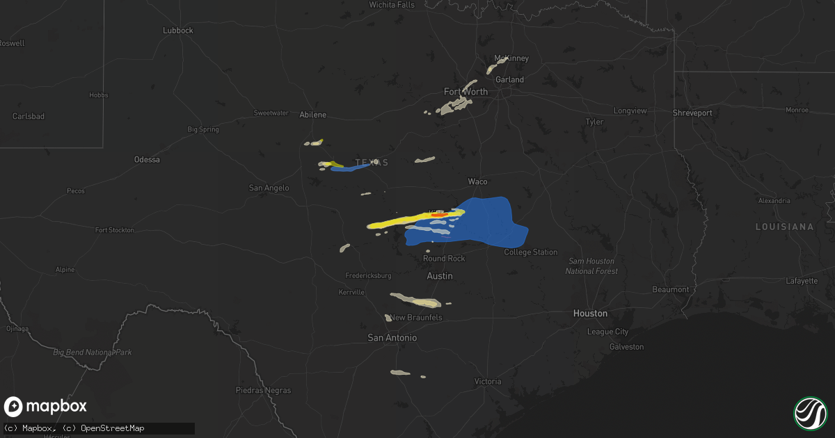
Hail Map on October 24, 2022
Get this storm
October 24 map
$229
one time, instant access
Download today. No call, no setup
Keep the $229
Bought the map and want the full workflow? Apply the entire $229 to a subscription within 7 days. None of it is wasted.
Every map, not just this one
This buys you this map. Subscription and you get every map we run, in the markets you choose from a few cities to whole states to nationwide. Plus real-time alerts the moment a storm fires.
Contact data
Name, contact info, occupancy, even credit band for addresses in the footprint. You go from where it hit to who to call.
Become the source they trust
Unlimited branding weather history reports on demand. You already have the documented answer ready for the property owner, and you are the one who showed up with it.
Property data and RoofTrace estimates
Pull up any address you have got, its value and the exact code rules for that jurisdiction, straight from One Click Code. Then RoofTrace estimates the squares, pitch, and roof value, priced the way you price.
Storm reports
Texas
| Date | Description |
|---|---|
| 10/24/20225:54 PM CDT | A local report indicates 1.00 inch wind near COLEMAN |
| 10/24/20225:39 PM CDT | Report from mping: 1-inch tree limbs broken; shingles blown off. |
| 10/24/20224:45 PM CDT | Jim korman reported winds up to approximately 58 mph in the city of rule on facebook. |
| 10/24/202210:01 AM CDT | Spotter network report of 60 mph winds in decatur. |
| 10/24/20229:55 AM CDT | Delayed report: emergency manager reports damaging to buildings in/around paradise. Most of the damage is garage doors being blown in. |
| 10/24/20226:51 AM CDT | At 1150 PM CDT, severe thunderstorms were located along a line extending from 8 miles north of Arp to near New Salem to 8 miles northwest of Kennard, moving northeast at 60 mph. HAZARD...60 mph wind gusts and penny size hail. SOURCE...Radar indicated. IMPACT...Expect damage to roofs, siding, and trees. Locations impacted include... Nacogdoches, Henderson, Kilgore, Overton, Troup, Alto, New London, Arp, Wells, Morrill, Ponta, New Salem, Trawick, Joinerville, Sacul, Turnertown, Forest, Douglass, Minden and Cushing. |
| 10/24/20226:28 AM CDT | At 1128 PM CDT, a severe thunderstorm was located 9 miles southwest of Maydelle, or 14 miles east of Palestine, moving northeast at 50 mph. HAZARD...60 mph wind gusts and quarter size hail. SOURCE...Radar indicated. IMPACT...Hail damage to vehicles is expected. Expect wind damage to roofs, siding, and trees. Locations impacted include... Crystal Lake, Slocum, Denson Spring and Mound City. |
| 10/24/20226:24 AM CDT | At 1123 PM CDT, a severe thunderstorm was located 12 miles west of Huntsville, moving east at 40 mph. HAZARD...60 mph wind gusts and penny size hail. SOURCE...Radar indicated. IMPACT...Expect damage to roofs, siding, and trees. Locations impacted include... Huntsville, Willis, New Waverly, Riverside, Huntsville State Park, Crabbs Prairie, Roans Prairie and Richards. |
| 10/24/20226:22 AM CDT | At 1122 PM CDT, a severe thunderstorm was located 13 miles southwest of Poth, moving east at 40 mph. HAZARD...60 mph wind gusts and quarter size hail. SOURCE...Radar indicated. IMPACT...Hail damage to vehicles is expected. Expect wind damage to roofs, siding, and trees. Locations impacted include... Kenedy, Karnes City, Poth, Yorktown, Kosciusko, Runge, Falls City, Nordheim, Cestohowa, Coy City, Cotton Patch, Gruenau, New Davy, Paweleville, Choate, Fashing, Hobson, Ecleto, Helena and Deweesville. |
| 10/24/20226:17 AM CDT | At 1116 PM CDT, severe thunderstorms were located along a line extending from near Frankston to near Elkhart, moving east at 50 mph. HAZARD...60 mph wind gusts and penny size hail. SOURCE...Radar indicated. IMPACT...Expect damage to roofs, siding, and trees. Locations impacted include... Jacksonville, Rusk, Mount Selman, Mixon, Reese, Ponta, Maydelle, New Summerfield, Gallatin, Cuney, Teaselville and Concord. |
| 10/24/20225:44 AM CDT | At 1042 PM CDT, a severe thunderstorm was located near Kurten, or 7 miles northeast of Bryan, moving east at 45 mph. HAZARD...60 mph wind gusts and quarter size hail. SOURCE...Radar indicated. At 1035 PM CDT, 61 mph winds were reported at Easterwood Field in College Station. Power flashes were also reported at 1040 PM CDT near University Drive in College Station. IMPACT...Hail damage to vehicles is expected. Expect wind damage to roofs, siding, and trees. Locations impacted include... College Station, Bryan, Navasota, Madisonville, Bedias, Kurten, Wixon Valley, Millican, Anderson, Kyle Field, Iola, North Zulch, Plantersville, Wellborn, Roans Prairie, Richards and Carlos. |
| 10/24/20225:14 AM CDT | At 1013 PM CDT, severe thunderstorms were located along a line extending from 9 miles south of Teague to 6 miles southeast of Lake Limestone to 7 miles east of Twin Oak Reservoir, moving east at 45 mph. HAZARD...60 mph wind gusts and quarter size hail. SOURCE...Radar indicated. IMPACT...Hail damage to vehicles is expected. Expect wind damage to roofs, siding, and trees. Locations impacted include... Teague, Buffalo, Centerville, Lake Limestone, Twin Oak Reservoir, Corinth, Jewett, Redland, Oakwood, Marquez, Pleasant Springs, Lanely, Flo, Seale, Donie, Robbins, Eunice, Freestone, Bald Prairie and Farrar.This includes Interstate 45 between mile markers 162 and 193. |
| 10/24/20225:13 AM CDT | At 1012 AM CDT, severe thunderstorms were located along a line extending from 6 miles west of Krum to Azle to 8 miles south of Aledo, moving east at 55 mph. HAZARD...60 mph wind gusts. SOURCE...Radar indicated. IMPACT...Expect damage to roofs, siding, and trees. Locations impacted include... Dallas, Fort Worth, Arlington, Plano, Irving, Grand Prairie, Carrollton, Frisco, Denton, Lewisville, Flower Mound, Mansfield, Euless, Bedford, Grapevine, Cedar Hill, Haltom City, Keller, Coppell and Duncanville.This includes the following highways... Interstate 35 between mile markers 468 and 473. Interstate 35W between mile markers 38 and 85. Interstate 35E between mile markers 434 and 466. Interstate 20 between mile markers 417 and 461. Interstate 30 between mile markers 1 and 40. |
| 10/24/20225:09 AM CDT | At 1008 PM CDT, a severe thunderstorm was located near Hearne, moving east at 40 mph. HAZARD...60 mph wind gusts and quarter size hail. SOURCE...Radar indicated. IMPACT...Hail damage to vehicles is expected. Expect wind damage to roofs, siding, and trees. Locations impacted include... Hearne, Benchley, Wheelock and Mumford. |
| 10/24/20225:08 AM CDT | At 1008 PM CDT, severe thunderstorms were located along a line extending from near Tanglewood to Cedar Creek to near Zorn to Live Oak, moving east at 30 mph. HAZARD...60 mph wind gusts and nickel size hail. SOURCE...Radar indicated. IMPACT...Expect damage to roofs, siding, and trees. Locations impacted include... New Braunfels, San Marcos, Schertz, Kyle, Seguin, Cibolo, Universal City, Live Oak, Lockhart, Selma, Bastrop, Gonzales, Luling, Giddings, La Grange, Smithville, Flatonia, Lexington, Randolph AFB and Garden Ridge. |
| 10/24/20225:02 AM CDT | At 1001 PM CDT, a severe thunderstorm was located 9 miles southwest of Hearne, moving east at 35 to 45 mph. HAZARD...60 mph wind gusts and quarter size hail. SOURCE...Radar indicated. IMPACT...Hail damage to vehicles is expected. Expect wind damage to roofs, siding, and trees. Locations impacted include... College Station, Bryan, Kurten, Wixon Valley, Millican, Kyle Field and Wellborn. |
| 10/24/20224:41 AM CDT | At 940 AM CDT, severe thunderstorms were located along a line extending from near Paradise to near Poolville to near Western Lake, moving east at 50 mph. HAZARD...60 mph wind gusts. SOURCE...Radar indicated. IMPACT...Expect damage to roofs, siding, and trees. Locations impacted include... Fort Worth, Denton, Weatherford, Benbrook, Saginaw, White Settlement, Azle, River Oaks, Decatur, Bridgeport, Sansom Park, Lake Worth, Eagle Mountain, Briar, Pecan Acres, Krum, Willow Park, Justin, Reno and Aledo.This includes the following highways... Interstate 20 between mile markers 397 and 431. Interstate 30 between mile markers 1 and 10. |
| 10/24/20224:24 AM CDT | At 923 PM CDT, severe thunderstorms were located along a line extending from near Marlin to Rosebud to 9 miles south of Buckholts, moving east at 45 mph. HAZARD...Ping pong ball size hail and 60 mph wind gusts. SOURCE...Radar indicated. IMPACT...People and animals outdoors will be injured. Expect hail damage to roofs, siding, windows, and vehicles. Expect wind damage to roofs, siding, and trees. Locations impacted include... Temple, Marlin, Rockdale, Cameron, Hearne, Groesbeck, Bartlett, Salado, Little River-Academy, Troy, Franklin, Rosebud, Thorndale, Rogers, Calvert, Holland, Bremond, Lott, Golinda and Buckholts.This includes Interstate 35 between mile markers 296 and 314. |
| 10/24/20224:14 AM CDT | At 913 PM CDT, severe thunderstorms were located along a line extending from Henly to near Spring Branch to near Bergheim, moving east at 55 mph. HAZARD...60 mph wind gusts and penny size hail. SOURCE...Radar indicated. IMPACT...Expect damage to roofs, siding, and trees. Locations impacted include... New Braunfels, San Marcos, Schertz, Kyle, Seguin, Cibolo, Buda, Lockhart, Selma, Luling, Dripping Springs, Wimberley, Canyon Lake Dam, Canyon Lake, Fair Oaks Ranch, Bulverde, Garden Ridge, McQueeney, Woodcreek and Martindale. |
| 10/24/20224:10 AM CDT | At 910 PM CDT, severe thunderstorms were located along a line extending from near Weir to near Anderson Mill to near Dripping Springs, moving east at 50 mph. HAZARD...60 mph wind gusts and penny size hail. SOURCE...Radar indicated. IMPACT...Expect damage to roofs, siding, and trees. Locations impacted include... Austin, Round Rock, Cedar Park, Georgetown, Pflugerville, Taylor, Elgin, Dripping Springs, Tanglewood Forest, Serenada, Anderson Mill, Austin Bergstrom Int Airport, Windemere, Leander, Hutto, Lakeway, Manor, Lago Vista, Bee Cave and West Lake Hills. |
| 10/24/20223:46 AM CDT | At 845 PM CDT, a severe thunderstorm was located over Belton Lake, or near Belton, moving east at 40 mph. HAZARD...Ping pong ball size hail and 60 mph wind gusts. SOURCE...Radar indicated. IMPACT...People and animals outdoors will be injured. Expect hail damage to roofs, siding, windows, and vehicles. Expect wind damage to roofs, siding, and trees. Locations impacted include... Killeen, Temple, Harker Heights, Belton, Robinson, Rockdale, Cameron, Nolanville, Morgan's Point Resort, Bartlett, Salado, Little River-Academy, Lorena, Troy, Bruceville-Eddy, Rosebud, Moody, Rogers, Holland and Lott.This includes Interstate 35 between mile markers 278 and 321. |
| 10/24/20223:10 AM CDT | At 810 PM CDT, a severe thunderstorm was located over Lake Victor, or 10 miles south of Lampasas, moving east at 40 mph. HAZARD...70 mph wind gusts and penny size hail. SOURCE...Radar indicated. IMPACT...Expect considerable tree damage. Damage is likely to mobile homes, roofs, and outbuildings. Locations impacted include... Georgetown, Burnet, Bertram, Buchanan Dam, Serenada, Jarrell, Florence, Weir, Inks Lake State Park, Georgetown Dam, Watson, Oatmeal, Briggs, Sun City, Lake Victor, Mahomet, Sunnylane, Joppa, Andice and Shady Grove. |
| 10/24/20222:55 AM CDT | At 755 PM CDT, a severe thunderstorm was located near Kempner, or 8 miles east of Lampasas, moving east at 40 mph. HAZARD...Two inch hail and 60 mph wind gusts. SOURCE...Radar indicated. IMPACT...People and animals outdoors will be injured. Expect hail damage to roofs, siding, windows, and vehicles. Expect wind damage to roofs, siding, and trees. Locations impacted include... Sunnylane and Watson. |
| 10/24/20222:55 AM CDT | At 754 PM CDT, a severe thunderstorm was located near Kempner, or 7 miles east of Lampasas, moving east at 35 mph. HAZARD...60 mph wind gusts and half dollar size hail. SOURCE...Radar indicated. IMPACT...Hail damage to vehicles is expected. Expect wind damage to roofs, siding, and trees. Locations impacted include... Killeen, Copperas Cove, Harker Heights, Belton, Fort Hood, Nolanville, Salado, Kempner, Stillhouse Hollow Lake, Belton Lake, Union Grove, Ding Dong, Maxdale, Owl Creek, Youngsport, Woodland, The Grove, Cedar Valley, Rumley and Prairie Dell.This includes Interstate 35 between mile markers 280 and 289. |
| 10/24/20222:23 AM CDT | At 723 PM CDT, a severe thunderstorm was located 8 miles east of Colorado Bend State Park, or 9 miles west of Lampasas, moving east at 35 mph. HAZARD...60 mph wind gusts and quarter size hail. SOURCE...Radar indicated. IMPACT...Hail damage to vehicles is expected. Expect wind damage to roofs, siding, and trees. Locations impacted include... Copperas Cove, Lampasas, Kempner, Nix and Rumley. |
| 10/24/20222:05 AM CDT | Wind gust was measured at the crab lake weatherflow site. |
| 10/24/20222:01 AM CDT | At 659 PM CDT, a severe thunderstorm was located near Baby Head, or 13 miles north of Llano, moving east at 40 mph. HAZARD...60 mph wind gusts and quarter size hail. SOURCE...Radar indicated. IMPACT...Hail damage to vehicles is expected. Expect wind damage to roofs, siding, and trees. Locations impacted include... Buchanan Lake Village, Lake Victor, Baby Head, Sunnylane, Watson, Tow and Briggs. |
| 10/24/20221:47 AM CDT | At 647 PM CDT, a severe thunderstorm was located near Cherokee, moving east at 35 mph. HAZARD...60 mph wind gusts and quarter size hail. SOURCE...Radar indicated. IMPACT...Hail damage to vehicles is expected. Expect wind damage to roofs, siding, and trees. This severe thunderstorm will be near... Chappel around 705 PM CDT. |
| 10/24/20221:41 AM CDT | At 641 PM CDT, a severe thunderstorm was located over Blanket, or 9 miles northeast of Early, moving east at 35 mph. HAZARD...60 mph wind gusts and quarter size hail. SOURCE...Radar indicated. IMPACT...Hail damage to vehicles is expected. Expect wind damage to roofs, siding, and trees. Locations impacted include... Comanche, Gustine, Proctor Lake, Comyn, Lamkin, Newburg, Downing, Energy, Proctor, Van Dyke, Hasse and Sidney. |
| 10/24/202212:50 AM CDT | Tree reported down in the west bound lane of hwy 204 at the county line in sacul. |
| 10/24/202212:48 AM CDT | Multiple trees reported down on sh 315 about 5 miles ne of mount enterprise. |
| 10/24/202212:39 AM CDT | At 539 PM CDT, a severe thunderstorm was located near Valera, moving east at 50 mph. HAZARD...60 mph wind gusts and quarter size hail. SOURCE...Radar indicated. IMPACT...Hail damage to vehicles is expected. Expect wind damage to roofs, siding, and trees. This severe thunderstorm will be near... Coleman around 545 PM CDT. Santa Anna around 550 PM CDT. Bangs, Lake Brownwood Near Thrifty, Lake Brownwood and Grosvenor around 605 PM CDT. Lake Brownwood State Park and Byrds around 610 PM CDT. Early around 620 PM CDT. Blanket around 630 PM CDT.Other locations impacted by this severe thunderstorm include Owens,Fisk, Thrifty, Echo and Hords Creek Reservoir. |
| 10/24/202212:32 AM CDT | Several trees and large limbs reported down on rosborough drive and pincrest drive in marshall. |
| 10/24/202212:25 AM CDT | Tree reported down 400 block of cr 635. |
| 10/24/202212:24 AM CDT | Trees down i-20 and exit 604 near hallsville. |
| 10/24/202212:24 AM CDT | Multiple trees down on state highway 315. |
| 10/24/202212:13 AM CDT | At 512 PM CDT, a severe thunderstorm was located near Goldsboro, or near Lawn, moving east at 35 mph. HAZARD...60 mph wind gusts and quarter size hail. SOURCE...Radar indicated. IMPACT...Hail damage to vehicles is expected. Expect wind damage to roofs, siding, and trees. This severe thunderstorm will be near... Novice around 525 PM CDT. Oplin around 530 PM CDT. Rowden around 550 PM CDT. Cross Plains and Cross Cut around 605 PM CDT.Other locations impacted by this severe thunderstorm includeGoldsboro, Lake Winters Lake, Us-283 Near The Coleman-Callahan County Line, Echo, Lake Coleman and Ovalo. |
| 10/23/202211:58 PM CDT | Multiple pictures on social media of large tree branches down near the intersection of i-45 and fm1488. Time is radar estimated. |
| 10/23/202211:55 PM CDT | Lines down and power outages in reklaw area. |
| 10/23/202211:54 PM CDT | Trees down on hwy 476. |
| 10/23/202211:47 PM CDT | Downed tree caused damage to nearby building on walden road near lake conroe. Time is radar estimated. |
| 10/23/202211:42 PM CDT | At 440 PM CDT, severe thunderstorms were located along a line extending from near Rule to near The Intersection Of Us-180 And Ranch Road 126, moving northeast at 45 mph. HAZARD...60 mph wind gusts. SOURCE...Radar indicated. IMPACT...Expect damage to roofs, siding, and trees. Severe thunderstorms will be near... Rule and Rochester around 445 PM CDT. O'brien around 450 PM CDT. Weinert around 500 PM CDT. Avoca around 510 PM CDT. Lueders around 515 PM CDT.Other locations impacted by these severe thunderstorms includeFunston, Us-277 Near The Haskell-Knox County Line, Tuxedo, Jud, Us-380 Near The Haskell-Stonewall County Line, Truby and The Intersection Of Us-180 And Farm Road 600. |
| 10/23/202211:30 PM CDT | Trees down on hwy 69. |
| 10/23/202211:26 PM CDT | At 425 PM CDT, a severe thunderstorm was located over Fort Chadbourne, moving east at 30 mph. HAZARD...60 mph wind gusts and quarter size hail. SOURCE...Radar indicated. IMPACT...Hail damage to vehicles is expected. Expect wind damage to roofs, siding, and trees. This severe thunderstorm will be near... Wingate around 445 PM CDT. Happy Valley around 450 PM CDT. Winters around 455 PM CDT. Bradshaw around 510 PM CDT.Other locations impacted by this severe thunderstorm include Wilmeth,Drasco, Camp Tonkawa, Pumphrey and Oak Creek Reservoir. |
| 10/23/202211:08 PM CDT | Large pecan tree branches down at shirewood drive at westwood main drive in bryan... Tx. |
| 10/23/202210:55 PM CDT | Measured gust to 59 mph at palestine awos. |
| 10/23/202210:35 PM CDT | Cll asos reported 61 mph wind gust at 10:35pm cdt. |
| 10/23/202210:30 PM CDT | Tree down |
| 10/23/202210:22 PM CDT | Tree down across house... Power line down on n. Archer street. |
| 10/23/202210:22 PM CDT | Lockhart co emergency management reports downed trees and power lines in downtown lockhart. Time estimated from radar. |
| 10/23/202210:19 PM CDT | Delayed report. Damage observed at both crescent drive and land lane. Trees uprooted and snapped midway; trees laying mostly in an eastward direction. Very large tree f |
| 10/23/202210:13 PM CDT | Medium to large tree branches down in caldwell. Time is radar estimated. |
| 10/23/20229:45 PM CDT | *** 1 inj *** delayed report: plywood blown through bedroom window causing minor cuts and scratches on an individuals head and arm. |
| 10/23/20229:42 PM CDT | Trained spotter reports a measured wind gust of 60 mph at the intersection of w centerpoint and wonder world dr. Time estimated from radar. |
| 10/23/20229:35 PM CDT | Delayed report: two small outbuildings destroyed. Scattered damage to power poles and tree limbs nearby. |
| 10/23/20229:25 PM CDT | Large... Downed tree onto fencing. Time estimated via radar. |
| 10/23/20229:10 PM CDT | Several 4 inch tree limbs down in temple. |
| 10/23/20229:03 PM CDT | Public report of broken one inch tree limbs and shingles blown off of roofs. Time of report estimated from radar. |
| 10/23/20228:54 PM CDT | A large... Uprooted tree fell into fencing. Time estimated via radar. |
| 10/23/20228:50 PM CDT | Law enforcement reports an overturned 18 wheeler and cars in the ditch along i-35 approximately 2 miles south-southwest of jarrell. Time and report location estimated f |
| 10/23/20228:50 PM CDT | Tdem district command reports trailers blocking the i-35 service road in jarrell. Also reports windows blown out at the jarrell fire station. Report time estimated from |
| 10/23/20228:50 PM CDT | 4 inch tree snapped in half. |
| 10/23/20228:48 PM CDT | Asos measured wind gust at the temple airport. |
| 10/23/20228:45 PM CDT | Report of quarter sized hail. |
| 10/23/20228:40 PM CDT | Estimated winds of 60 mph south of harker heights. |
| 10/23/20228:30 PM CDT | Half dollar sized hail reported in harker heights. |
| 10/23/20228:29 PM CDT | Public report from 4 miles nne of burnet of three inch tree limbs broken and snapped power poles. |
| 10/23/20228:29 PM CDT | 1 inch hail reported in frisco. |
| 10/23/20228:25 PM CDT | Public report of three inch tree limbs and broken power poles 2 miles north-northeast of granite shoals. Time estimated from radar. |
| 10/23/20228:24 PM CDT | Report of golf ball sized hail in killeen. |
| 10/23/20228:12 PM CDT | Half dollar sized hail reported on boys ranch road. |
Oklahoma
| Date | Description |
|---|---|
| 10/24/202212:55 PM CDT | Thunderstorm wind gust of 59.3 mph measured at the porter mesonet. |
| 10/24/20229:21 AM CDT | Trampoline blown across sooner road. Time based on radar. |
| 10/24/20227:17 AM CDT | At 1217 PM CDT, a severe thunderstorm was located over Verdigris, moving east at 20 mph. HAZARD...60 mph wind gusts. SOURCE...Radar indicated. IMPACT...Expect damage to roofs, siding, and trees. Locations in or near the path include... Claremore... Catoosa... Verdigris... Taiwah... Tiawah... This includes Interstate 44 between mile markers 239 and 259. |
| 10/24/20226:36 AM CDT | At 1135 AM CDT, a severe thunderstorm was located 5 miles northeast of Sand Springs, moving northeast at 40 mph. HAZARD...60 mph wind gusts. SOURCE...Radar indicated. IMPACT...Expect damage to roofs, siding, and trees. Locations in or near the path include... Tulsa... Broken Arrow... Sand Springs... Claremore... Owasso... Bixby... Sapulpa... Jenks... Glenpool... Coweta... Skiatook... Catoosa... Collinsville... Verdigris... Chelsea... Inola... Kiefer... Sperry... Oologah... Foyil...This includes Interstate 44 between mile markers 207 and 258. |
| 10/24/20225:40 AM CDT | At 1040 AM CDT, severe thunderstorms were located along a line extending from near Vanoss to near Scullin to 6 miles southwest of Mill Creek to 3 miles west of Mannsville, moving northeast at 40 mph. HAZARD...60 mph wind gusts. SOURCE...Radar indicated. IMPACT...Expect damage to roofs, siding, and trees. Locations impacted include... Ada, Holdenville, Sulphur, Tishomingo, Wewoka, Konawa, Dickson, Byng, Allen, Roff, Ravia, Stonewall, Wapanucka, Tupelo, Mill Creek, Francis, Fitzhugh, Bromide, Sasakwa and Yeager. |
| 10/24/20224:10 AM CDT | At 909 AM CDT, a severe thunderstorm was located near Moore, moving east at 30 mph. HAZARD...60 mph wind gusts. SOURCE...Radar indicated. IMPACT...Expect damage to roofs, siding, and trees. Locations impacted include... Southern Oklahoma City, northern Norman, Moore, Stanley Draper Lake and northwestern Lake Thunderbird. |
| 10/24/20224:03 AM CDT | At 903 AM CDT, a severe thunderstorm was located over southeastern Oklahoma City, or near Smith Village, moving east at 30 mph. HAZARD...60 mph wind gusts. SOURCE...Radar indicated. IMPACT...Expect damage to roofs, siding, and trees. Locations impacted include... Oklahoma City, Midwest City, Del City, Choctaw, Spencer, Jones, Nicoma Park, Tinker Air Force Base, Forest Park, Lake Aluma and Smith Village. |
| 10/23/20229:04 PM CDT | At 204 PM CDT, a severe thunderstorm was located 6 miles west of Scraper, moving east at 30 mph. HAZARD...60 mph wind gusts. SOURCE...Radar indicated. IMPACT...Expect damage to roofs, siding, and trees. Locations in or near the path include... Oaks... Scraper... |
| 10/23/20228:32 PM CDT | At 131 PM CDT, a severe thunderstorm was located near Locust Grove, moving northeast at 25 mph. HAZARD...60 mph wind gusts. SOURCE...Radar indicated. IMPACT...Expect damage to roofs, siding, and trees. Locations in or near the path include... Locust Grove... Salina... |
Louisiana
| Date | Description |
|---|---|
| 10/24/20224:59 AM CDT | Photos received of structural damage to a barn as well as an aluminum carport covering blown into the yard. Time estimated by radar. |
| 10/24/20223:09 AM CDT | Tree reported down near hwy 146 and point pleasant. |
| 10/24/20221:36 AM CDT | Tree down on irving bluff road. |
Cities Impacted by Hail Map on October 24, 2022
- Belton, TX
- Kempner, TX
- Copperas Cove, TX
- Lampasas, TX
- Clarendon, TX
- Llano, TX
- Valley Spring, TX
- Nolanville, TX
- San Saba, TX
- Cherokee, TX
- Temple, TX
- Killeen, TX
- Fort Hood, TX
- Harker Heights, TX
- Granbury, TX
- New Braunfels, TX
- Martindale, TX
- Canyon Lake, TX
- San Marcos, TX
- Fischer, TX
- Maxwell, TX
- Fort Worth, TX
- Tow, TX
- Frisco, TX
- Mckinney, TX
- Valera, TX
- Talpa, TX
- Coleman, TX
- Leander, TX
- Georgetown, TX
- Blanco, TX
- Wimberley, TX
- Spring Branch, TX
- Kendalia, TX
- Lockhart, TX
- Kyle, TX
- Pleasanton, TX
- Falls City, TX
- Blanket, TX
- Salado, TX
- Winters, TX
- Lawn, TX
- Comanche, TX
- Zephyr, TX
- Richland Springs, TX
- Rochelle, TX
- Hobson, TX
- Karnes City, TX
- San Antonio, TX
- Goldsboro, TX
- Novice, TX
- The Colony, TX
- Carrollton, TX
- Haltom City, TX
- North Richland Hills, TX
- Hurst, TX
- Colleyville, TX
- Cranfills Gap, TX
- Hamilton, TX
- Hico, TX
- Meridian, TX
- Iredell, TX
- Lewisville, TX
- Coppell, TX
- Mason, TX
- Florence, TX
- Burnet, TX
- Jarrell, TX
- Bertram, TX
- Briggs, TX
- Weatherford, TX
- Joshua, TX
- Crowley, TX
- Burleson, TX
- Aledo, TX
- Godley, TX
- Cresson, TX
- Tolar, TX
- Voss, TX
- Santa Anna, TX
- Ovalo, TX
- Inola, OK
- Waurika, OK
- Bangs, TX
- Brownwood, TX
- Early, TX
- Bruceville, TX
- Lott, TX
- Holland, TX
- Kosse, TX
- Thorndale, TX
- Calvert, TX
- Bartlett, TX
- Liberty Hill, TX
- Bryan, TX
- Gause, TX
- Caldwell, TX
- Bremond, TX
- Rosebud, TX
- Davilla, TX
- Granger, TX
- Reagan, TX
- Franklin, TX
- Hearne, TX
- Cameron, TX
- Little River Academy, TX
- Rogers, TX
- Moody, TX
- Marlin, TX
- Rockdale, TX
- Milano, TX
- Burlington, TX
- Chilton, TX
- Eddy, TX
- Troy, TX
- Buckholts, TX