Hail Map in Arizona on October 21, 2026
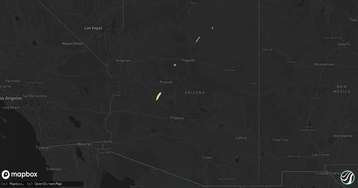
Get this storm
October 21 map
$229
one time, instant access
Download today. No call, no setup
Keep the $229
Bought the map and want the full workflow? Apply the entire $229 to a subscription within 7 days. None of it is wasted.
Every map, not just this one
This buys you this map. Subscription and you get every map we run, in the markets you choose from a few cities to whole states to nationwide. Plus real-time alerts the moment a storm fires.
Contact data
Name, contact info, occupancy, even credit band for addresses in the footprint. You go from where it hit to who to call.
Become the source they trust
Unlimited branding weather history reports on demand. You already have the documented answer ready for the property owner, and you are the one who showed up with it.
Property data and RoofTrace estimates
Pull up any address you have got, its value and the exact code rules for that jurisdiction, straight from One Click Code. Then RoofTrace estimates the squares, pitch, and roof value, priced the way you price.
Storm reports in Arizona
Arizona
| Date | Description |
|---|---|
| 10/21/20266:56 PM CDT | Measured biggest hail stone of quarter sized hail. |
| 10/21/20266:46 PM CDT | Measured peak wind gust of 61 mph. |
| 10/21/20265:45 PM CDT | A local report indicates 1.75 inch wind near 5 E Deer Valley |
| 10/21/20265:45 PM CDT | A local report indicates 1.50 inch wind near 5 ENE Deer Valley |
| 10/21/20265:43 PM CDT | A local report indicates 1.00 inch wind near 5 SE Deer Valley |
| 10/21/20265:42 PM CDT | A local report indicates 1.75 inch wind near 4 E Deer Valley |
| 10/21/20265:40 PM CDT | Photo of multiple hail stones next to a tape measure with the largest stone around 1.25 inches. |
| 10/21/20265:40 PM CDT | A local report indicates 1.25 inch wind near 3 ENE Deer Valley |
| 10/21/20265:40 PM CDT | A local report indicates 1.00 inch wind near 3 ESE Deer Valley |
| 10/21/20265:38 PM CDT | Report from mping: quarter |
| 10/21/20265:35 PM CDT | A local report indicates 1.50 inch wind near 4 S Deer Valley |
| 10/21/20265:34 PM CDT | Photo of a few hail stones with the largest estimated at 2 inches in diameter. |
| 10/21/20265:32 PM CDT | A local report indicates 1.50 inch wind near 4 NE Glendale |
| 10/21/20265:32 PM CDT | A local report indicates 1.00 inch wind near 2 NE Glendale |
| 10/21/20265:30 PM CDT | A local report indicates 60 MPH wind near 4 ESE Glendale |
| 10/21/20265:30 PM CDT | A local report indicates 1.25 inch wind near 6 SSE Deer Valley |
| 10/21/20265:30 PM CDT | A local report indicates 1.75 inch wind near 4 SSE Deer Valley |
| 10/21/20265:30 PM CDT | A local report indicates 1.25 inch wind near 5 SSW Deer Valley |
| 10/21/20265:25 PM CDT | A local report indicates 1.00 inch wind near 5 NE Glendale |
| 10/21/20265:25 PM CDT | A local report indicates 1.00 inch wind near 4 ENE Peoria |
| 10/21/202612:43 PM CDT | Public reported via facebook hail up to the size of golf balls. |
| 10/21/202612:39 PM CDT | Law enforcement reported downed trees on walker road between mile markers 3 and 4 near lynx lake. |
| 10/21/202612:34 PM CDT | Public reported... Via facebook... Hail up to the size of ping pong balls. |
| 10/21/202612:08 PM CDT | Public reported... Via facebook... Hail up to the size of quarters. |
| 10/21/202611:43 AM CDT | Corrects previous hail report from 2 wsw downtown flagstaff. Public reported via facebook hail up to the size of golf balls. |
| 10/21/202611:38 AM CDT | A nws employee reported hail up to the size of ping pong balls. |
| 10/21/202611:34 AM CDT | Corrects previous hail report from 2 n flagstaff airport. Public reported... Via facebook... Hail up to the size of ping pong balls. |
| 10/21/202611:31 AM CDT | Public reported hail up to the size of half dollars. Hail accumulation on the ground. |
| 10/21/202611:28 AM CDT | Corrects previous hail report from 1 n downtown flagstaff. Public reported... Via facebook... Hail up to the size of quarters. |
| 10/21/202611:28 AM CDT | Public reported hail up to the size of half dollars. |
| 10/21/202611:24 AM CDT | Former nws employee reported quarter sized hail in the cheshire neighborhood. |
| 10/21/202611:20 AM CDT | Public reported hail up the size of half dollars. |
| 10/21/202611:18 AM CDT | Public reported hail up to the size of ping pong balls. Dents observed in a truck. |
| 10/21/202611:17 AM CDT | Asos station kflg flagstaff airport. |
| 10/21/20269:53 AM CDT | Report from wednesday morning. Yavapai sheriff office reported trees down and caused closure of walker rd around mile post 4. |
| 10/21/20269:39 AM CDT | Corrects previous tstm wnd gst report from 4 ese prescott courthouse. Yavapai county sheriff office reported 5 downed trees on walker road near mile marker 4 near lynx |
| 10/21/20269:32 AM CDT | An ef1 rated tornado developed south of walker and traveled north-northeast across walker road. The estimated maximum wind speed was 105 mph along its 8 mile path. Maxi |
| 10/21/20268:45 AM CDT | A former nws employee reported dozens of 1-2 ft diameter ponderosa pine trees down in the forest. Some trees were snapped. Time is estimated based on radar signatures. |
| 10/20/20269:02 PM CDT | *** 1 inj *** 46 structures sustained damaged in heber-overgaard. There was 1 non life-threatening injury to a bicyclist. Time of report is estimated by radar. Further |
| 10/20/20268:59 PM CDT | *** 1 inj *** approximate start point of an ef-1 rated tornado that moved north through the heber-overgaard area. Peak winds estimated to be 110 mph along its 11 minute |
| 10/20/20267:34 PM CDT | Photo of an estimated quarter-sized hail stone. |
All States Impacted by Hail Map on October 21, 2026
Cities Impacted by Hail Map on October 21, 2026
- Williams, AZ
- Chino Valley, AZ
- Flagstaff, AZ
- Wickenburg, AZ
- Hotevilla, AZ
- Congress, AZ
- Middleton, MI
- Ithaca, MI
- Kirkland, AZ
- Yarnell, AZ
- Prescott, AZ
- Tonto Basin, AZ
- Carson City, MI
- Sumner, MI
- Prescott Valley, AZ
- Sedona, AZ
- Clarkdale, AZ
- Payson, AZ
- Leupp, AZ
- Tuba City, AZ
- Pine, AZ
- Ash Fork, AZ
- Paulden, AZ
- Winslow, AZ
- Saint Johns, AZ
- Fence Lake, NM
- Kykotsmovi Village, AZ
- Benson, AZ
- Chambers, AZ
- Zuni, NM
- Gallup, NM
- Ramah, NM
- Keams Canyon, AZ
- Dulce, NM
- Bluewater, NM
- Farmington, NM
- Bloomfield, NM
- Willcox, AZ
- Winkelman, AZ
- Tolleson, AZ
- Phoenix, AZ
- Thoreau, NM
- Prewitt, NM
- Glendale, AZ
- Littlefield, AZ
- Laveen, AZ
- Datil, NM
- Show Low, AZ
- Colorado City, AZ
- Grants, NM
- Cave Creek, AZ
- Hurricane, UT
- Scottsdale, AZ
- Carefree, AZ
- Enterprise, UT
- Central, UT
- Safford, AZ
- Mesa, AZ
- Black Canyon City, AZ
- Fort Mcdowell, AZ
- Peach Springs, AZ
- Peridot, AZ
- Roosevelt, AZ
- Ivins, UT
- San Carlos, AZ
- Gunlock, UT
- Veyo, UT
- Saint George, UT
- Dammeron Valley, UT
- Young, AZ
- Forest Lakes, AZ
- Taylor, AZ
- Beryl, UT
- Pine Valley, UT
- Leeds, UT
- Heber, AZ
- Snowflake, AZ
- Overgaard, AZ
- Concho, AZ
- Springdale, UT
- Morenci, AZ
- Clifton, AZ
- Rockville, UT
- Virgin, UT
- Holbrook, AZ
- Buckhorn, NM
- Ganado, AZ
- Kaibeto, AZ
- Tonalea, AZ
- Parks, AZ
- Overton, NV
- Aragon, NM
- Mesquite, NV
- Bunkerville, NV
- Caliente, NV
- Mormon Lake, AZ
- Grand Canyon, AZ
- Alamo, NV
- Polacca, AZ
- Munds Park, AZ
- Sun City, AZ
- Surprise, AZ
- Peoria, AZ
- Marble Canyon, AZ
- New River, AZ
- Petrified Forest Natl Pk, AZ
- Florence, AZ
- Whiteriver, AZ
- Superior, AZ
- Miami, AZ
- Globe, AZ


