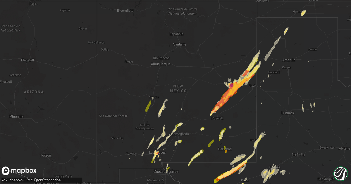
Hail Map in New Mexico on October 21, 2015
Get this storm
October 21 map
$229
one time, instant access
Download today. No call, no setup
Keep the $229
Bought the map and want the full workflow? Apply the entire $229 to a subscription within 7 days. None of it is wasted.
Every map, not just this one
This buys you this map. Subscription and you get every map we run, in the markets you choose from a few cities to whole states to nationwide. Plus real-time alerts the moment a storm fires.
Contact data
Name, contact info, occupancy, even credit band for addresses in the footprint. You go from where it hit to who to call.
Become the source they trust
Unlimited branding weather history reports on demand. You already have the documented answer ready for the property owner, and you are the one who showed up with it.
Property data and RoofTrace estimates
Pull up any address you have got, its value and the exact code rules for that jurisdiction, straight from One Click Code. Then RoofTrace estimates the squares, pitch, and roof value, priced the way you price.
Storm reports in New Mexico
New Mexico
| Date | Description |
|---|---|
| 10/21/20154:16 PM CDT | A local report indicates 1.00 inch wind near TULAROSA |
| 10/21/20153:22 PM CDT | A local report indicates 1.75 inch wind near LAS CRUCES |
| 10/21/20152:41 PM CDT | A local report indicates 1.00 inch wind near 2 NE MESILLA |
| 10/21/20152:41 PM CDT | A local report indicates 1.50 inch wind near 3 SSE LAS CRUCES |
| 10/21/20152:39 PM CDT | A local report indicates 1.50 inch wind near 1 SSE LAS CRUCES |
| 10/21/20152:33 PM CDT | Pea to quarter size hail 6 blocks away from nmsu. |
| 10/21/20152:27 PM CDT | At nmsu |
| 10/21/20152:24 PM CDT | A local report indicates 1.75 inch wind near 3 E MESILLA |
| 10/21/20152:23 PM CDT | A local report indicates 1.50 inch wind near 2 ESE LAS CRUCES |
| 10/21/20152:13 PM CDT | Pea to quarter size hail near las cruces. |
| 10/21/20152:10 PM CDT | A local report indicates 1.00 inch wind near 3 ESE LAS CRUCES |
| 10/21/20151:12 PM CDT | A local report indicates 1.00 inch wind near 3 W GLENRIO |
| 10/21/201512:18 PM CDT | A local report indicates 1.00 inch wind near WHEATLAND |
| 10/21/201512:00 PM CDT | A local report indicates 1.75 inch wind near 9 N SAINT VRAIN |
| 10/21/201511:48 AM CDT | A local report indicates 1.75 inch wind near MELROSE |
| 10/21/201511:40 AM CDT | A local report indicates 1.75 inch wind near 1 S MELROSE |
| 10/21/201511:25 AM CDT | A local report indicates 1.50 inch wind near 21 S TAIBAN |
| 10/21/201511:20 AM CDT | A local report indicates 2.50 inch wind near 2 W TAIBAN |
| 10/21/201511:18 AM CDT | A local report indicates 1.75 inch wind near 5 E TOLAR |
| 10/21/201511:17 AM CDT | A local report indicates 1.75 inch wind near 13 SE TOLAR |
| 10/21/20159:40 AM CDT | A local report indicates 1.25 inch wind near 21 N ROSWELL |
| 10/20/20158:10 PM CDT | A local report indicates 1.50 inch wind near CARLSBAD |
| 10/20/20157:52 PM CDT | A local report indicates 1.00 inch wind near CARLSBAD |
| 10/20/20157:47 PM CDT | A local report indicates 1.00 inch wind near 6 SSW CARLSBAD |
| 10/20/20157:40 PM CDT | At the junction of hamilton road and old cavern highway. |
| 10/20/20157:38 PM CDT | A local report indicates 1.00 inch wind near COTTONWOOD |
| 10/20/20157:28 PM CDT | A local report indicates 1.00 inch wind near ATOKA |
All States Impacted by Hail Map on October 21, 2015
Cities Impacted by Hail Map on October 21, 2015
- Tyrone, OK
- Melrose, NM
- Artesia, NM
- Lake Arthur, NM
- Socorro, NM
- Las Cruces, NM
- Mesilla, NM
- Mescalero, NM
- Bent, NM
- Tularosa, NM
- Mesilla Park, NM
- La Mesa, NM
- Alamogordo, NM
- Cloudcroft, NM
- Seminole, TX
- Odessa, TX
- Crane, TX
- Brady, TX
- Stratford, TX
- Dumas, TX
- Cactus, TX
- Grady, NM
- Broadview, NM
- Clovis, NM
- Pecos, TX
- Balmorhea, TX
- Loving, NM
- Jal, NM
- Mentone, TX
- Salt Flat, TX
- Roswell, NM
- Ralls, TX
- Crosbyton, TX
- Floydada, TX
- Midland, TX
- Carlsbad, NM
- Taiban, NM
- Guymon, OK
- Hooker, OK
- Hobbs, NM
- Monahans, TX
- Van Horn, TX
- Roaring Springs, TX
- Mcadoo, TX
- Chamberino, NM
- Anthony, NM
- Fort Sumner, NM
- Dalhart, TX
- Adrian, TX
- Channing, TX
- Vega, TX
- Floyd, NM
- Goldsmith, TX
- Elida, NM
- Hereford, TX
- San Jon, NM
- Hagerman, NM
- Mayhill, NM
- Eunice, NM
- Fort Stockton, TX
- Rincon, NM
- Bard, NM
- Deming, NM
- Claude, TX
- Fort Davis, TX
- Andrews, TX
- Carrizozo, NM
- Seagraves, TX
- Sudan, TX
- Farwell, TX
- El Paso, TX
- Fort Bliss, TX
- Garden City, TX
- Mcalister, NM
- Tucumcari, NM
- Dickens, TX
- Marathon, TX
- Kermit, TX
- Grandfalls, TX
- Midkiff, TX
- Barstow, TX
- Denver City, TX
- Bovina, TX
- Friona, TX
- White Sands Missile Range, NM
- Derry, NM
- Magdalena, NM


