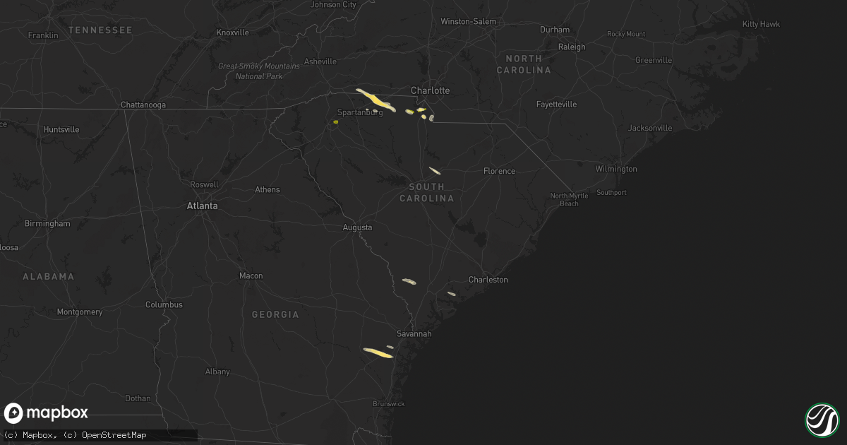
Hail Map in South Carolina on October 20, 2023
Get this storm
October 20 map
$229
one time, instant access
Download today. No call, no setup
Keep the $229
Bought the map and want the full workflow? Apply the entire $229 to a subscription within 7 days. None of it is wasted.
Every map, not just this one
This buys you this map. Subscription and you get every map we run, in the markets you choose from a few cities to whole states to nationwide. Plus real-time alerts the moment a storm fires.
Contact data
Name, contact info, occupancy, even credit band for addresses in the footprint. You go from where it hit to who to call.
Become the source they trust
Unlimited branding weather history reports on demand. You already have the documented answer ready for the property owner, and you are the one who showed up with it.
Property data and RoofTrace estimates
Pull up any address you have got, its value and the exact code rules for that jurisdiction, straight from One Click Code. Then RoofTrace estimates the squares, pitch, and roof value, priced the way you price.
Storm reports in South Carolina
South Carolina
| Date | Description |
|---|---|
| 10/20/20234:12 PM CDT | 3 trees down at 4068 white hall rd. |
| 10/20/20234:01 PM CDT | 1 tree down on hill rd. |
| 10/20/20233:42 PM CDT | Tree down at 2000 lento rd. |
| 10/20/20233:39 PM CDT | Tree fell on a power line along columbia ave near eagle chase ct. |
| 10/20/20233:30 PM CDT | A local report indicates 1.50 inch wind near 3 S Fort Mill |
| 10/20/20233:25 PM CDT | Social media picture of nickel to quarter size hail between york and rock hill. |
| 10/20/20233:25 PM CDT | 911 call center reported powerlines down on sherer rd. |
| 10/20/20233:10 PM CDT | 911 call center reported powerlines down on potato house rd and wylie rd. |
| 10/20/20233:03 PM CDT | A local report indicates 1.00 inch wind near 2 NNE Mauldin |
| 10/20/20232:57 PM CDT | Report from mping: quarter |
| 10/20/20232:45 PM CDT | A local report indicates 1.50 inch wind near 3 WNW Gaffney |
| 10/20/20232:41 PM CDT | Large piece of metal roofing blown off the cherokee county administration building. |
| 10/20/20232:41 PM CDT | Nickel to quarter size hail covering the ground. |
| 10/20/20232:33 PM CDT | Quarter size hail along hwy 11 near gaffney. |
| 10/20/20232:31 PM CDT | Awning ripped off the back of a home... Power line down. |
| 10/20/20232:25 PM CDT | Quarter size hail near the intersection of cabin creek rd and robbs school rd. |
All States Impacted by Hail Map on October 20, 2023
Cities Impacted by Hail Map on October 20, 2023
- Gaffney, SC
- Hickory Grove, SC
- York, SC
- Rutherfordton, NC
- Estill, SC
- Varnville, SC
- Rock Hill, SC
- Hinesville, GA
- Ludowici, GA
- Allenhurst, GA
- Midway, GA
- Riceboro, GA
- Chesnee, SC
- Mooresboro, NC
- Smyrna, SC
- Blacksburg, SC
- Sharon, SC
- Glennville, GA
- Fort Stewart, GA
- Elgin, SC
- Lugoff, SC
- Brunson, SC
- Luray, SC
- Green Pond, SC
- Hampton, SC
- Forest City, NC
- Columbus, NC
- Lyford, TX
- Raymondville, TX
- San Perlita, TX
- Sebastian, TX
- Fleming, GA
- Catawba, SC
- Fort Mill, SC
- Spartanburg, SC
- Lancaster, SC
- Pacolet, SC
- Mauldin, SC
- Greenville, SC
- Simpsonville, SC


