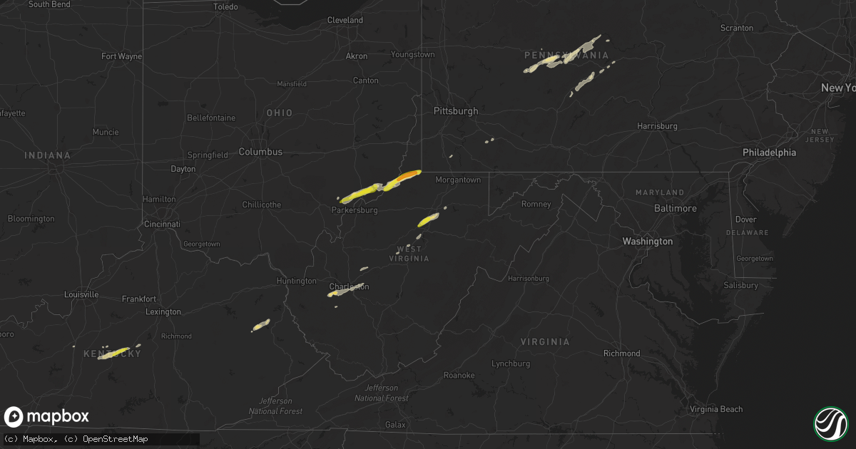
Hail Map in West Virginia on October 20, 2016
Get this storm
October 20 map
$229
one time, instant access
Download today. No call, no setup
Keep the $229
Bought the map and want the full workflow? Apply the entire $229 to a subscription within 7 days. None of it is wasted.
Every map, not just this one
This buys you this map. Subscription and you get every map we run, in the markets you choose from a few cities to whole states to nationwide. Plus real-time alerts the moment a storm fires.
Contact data
Name, contact info, occupancy, even credit band for addresses in the footprint. You go from where it hit to who to call.
Become the source they trust
Unlimited branding weather history reports on demand. You already have the documented answer ready for the property owner, and you are the one who showed up with it.
Property data and RoofTrace estimates
Pull up any address you have got, its value and the exact code rules for that jurisdiction, straight from One Click Code. Then RoofTrace estimates the squares, pitch, and roof value, priced the way you price.
Storm reports in West Virginia
West Virginia
| Date | Description |
|---|---|
| 10/20/20166:46 PM CDT | A local report indicates 1.00 inch wind near 5 E BRIDGEPORT |
| 10/20/20166:29 PM CDT | A local report indicates 1.25 inch wind near LOST CREEK |
| 10/20/20166:20 PM CDT | A local report indicates 1.00 inch wind near LOST CREEK |
| 10/20/20164:34 PM CDT | Per 911 center... Tree down at 57th st se and chesterfield ave in kanawha city. Radar estimated time. |
| 10/20/20163:44 PM CDT | A local report indicates 1.50 inch wind near 1 S NEW MARTINSVILLE |
| 10/20/20163:40 PM CDT | One tree down on intersection of route 2 and 180 |
| 10/20/20163:39 PM CDT | In paden city |
| 10/20/20163:37 PM CDT | One tree down on the intersection of east main street and 4th avenue |
| 10/20/20163:34 PM CDT | Numerous trees down across roads and power outages |
All States Impacted by Hail Map on October 20, 2016
Cities Impacted by Hail Map on October 20, 2016
- New Matamoras, OH
- Sistersville, WV
- Proctor, WV
- Littleton, WV
- Paden City, WV
- New Martinsville, WV
- Sardis, OH
- Gravel Switch, KY
- Campbellsville, KY
- Lebanon, KY
- Bradfordsville, KY
- Raywick, KY
- Flatgap, KY
- Salyersville, KY
- West Liberty, KY
- Oil Springs, KY
- Sitka, KY
- Walton, WV
- Elkview, WV
- Clendenin, WV
- Danville, KY
- Renovo, PA
- Cherokee, AL
- Flemington, WV
- State College, PA
- Port Matilda, PA
- Bellefonte, PA
- Graysville, OH
- Karthaus, PA
- Woodland, PA
- Frenchville, PA
- Morrisdale, PA
- Penfield, PA
- Clearfield, PA
- Curwensville, PA
- Grampian, PA
- Glen Richey, PA
- Mineral Springs, PA
- Hyde, PA
- Waterford, OH
- Marietta, OH
- Fleming, OH
- Friendly, WV
- Cameron, WV
- Jefferson, PA
- Waynesburg, PA
- Gassaway, WV
- Lebanon, TN
- Spruce Creek, PA
- Tyrone, PA
- Warriors Mark, PA
- Pennsylvania Furnace, PA
- Foster, WV
- Macedonia, IL
- Norris City, IL
- Broughton, IL
- McLeansboro, IL
- Dale, IL
- Jane Lew, WV
- Lost Creek, WV
- Du Bois, PA
- Rockton, PA
- Punxsutawney, PA
- Mahaffey, PA
- Rossiter, PA
- Glen Campbell, PA
- Pottersdale, PA
- Whipple, OH
- Wingett Run, OH
- Reno, OH
- Lowell, OH
- Cutler, OH
- Belpre, OH
- Vincent, OH
- Bradyville, TN
- Enfield, IL
- Rio Grande City, TX
- Mission, TX
- Sullivan City, TX
- Grulla, TX
- Alum Creek, WV
- Orlando, WV
- Weston, WV
- Walkersville, WV
- Connellsville, PA
- Scottdale, PA
- White, PA
- Bridgeport, WV
- Mount Clare, WV
- Loretto, KY
- Saint Francis, KY
- Beech Creek, PA
- Westport, PA
- Yawkey, WV
- Charleston, WV
- Sod, WV
- Sumerco, WV
- Tornado, WV
- South Charleston, WV
- Howard, PA
- Tad, WV
- Acme, PA
- Mill Hall, PA
- Lamar, PA
- Camden, WV
- Bishop, TX
- Luthersburg, PA
- Lock Haven, PA
- Glendale, KY
- Elizabethtown, KY
- Reader, WV
- Burnsville, WV
- Copen, WV
- Newport, OH
- Gainesville, TX
- Muenster, TX
- Lindsay, TX


