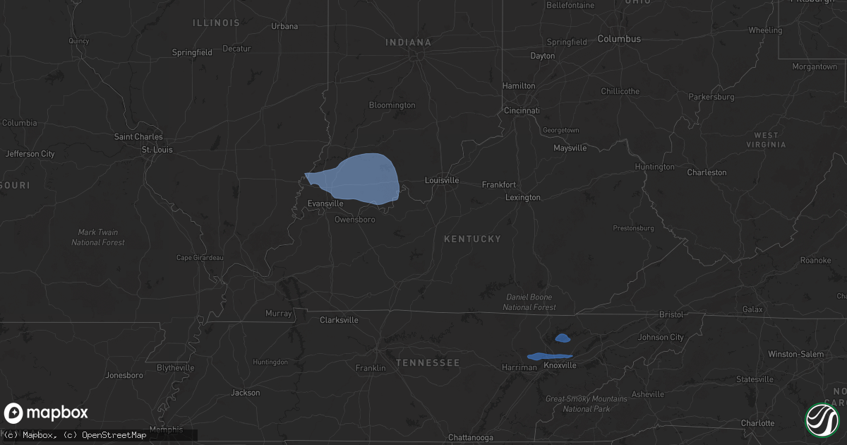
Hail Map in Kentucky on October 19, 2025
Get this storm
October 19 map
$229
one time, instant access
Download today. No call, no setup
Keep the $229
Bought the map and want the full workflow? Apply the entire $229 to a subscription within 7 days. None of it is wasted.
Every map, not just this one
This buys you this map. Subscription and you get every map we run, in the markets you choose from a few cities to whole states to nationwide. Plus real-time alerts the moment a storm fires.
Contact data
Name, contact info, occupancy, even credit band for addresses in the footprint. You go from where it hit to who to call.
Become the source they trust
Unlimited branding weather history reports on demand. You already have the documented answer ready for the property owner, and you are the one who showed up with it.
Property data and RoofTrace estimates
Pull up any address you have got, its value and the exact code rules for that jurisdiction, straight from One Click Code. Then RoofTrace estimates the squares, pitch, and roof value, priced the way you price.
Storm reports in Kentucky
Kentucky
| Date | Description |
|---|---|
| 10/19/20252:39 PM CDT | Law enforcement reported a tree down on lick mountain road in lick creek. Time was estimated from radar. |
| 10/19/20252:29 PM CDT | Down trees and powerlines were reported along east big creek road... Just off highway 119 outside the huddy community. Time was estimated from radar. |
| 10/19/20252:22 PM CDT | A tree was reported down near the racoon community along frozen creek court. Time was estimated from radar. |
| 10/19/20251:44 PM CDT | Tree was reported blown down and blocking a lane of ky-15 near jeff mart. Event time estimated from radar. |
| 10/19/20251:11 PM CDT | Tree damage was reported at the corner of 223 and moore creek road. |
| 10/19/20251:11 PM CDT | Reports of tree and power line damage all up and down ky 223 and ky 718. Time estimated from radar. |
| 10/19/20251:11 PM CDT | Trees reported down on aj gray cemetery road... Near flat lick. Time estimated from radar. |
| 10/19/20251:10 PM CDT | Trees were reported down on possum hollow road... Time estimated from radar. |
| 10/19/20251:00 PM CDT | Large tree down on hwy 2392. Reported around 2 pm. |
| 10/19/202511:05 AM CDT | Nws storm survey team determined an ef1 tornado with maximum winds of 90mph impacted western nicholasville... Ky on october 19... 2025. The tornado began as a cold air |
| 10/19/202511:05 AM CDT | An ef 1 tornado touched down briefly west of nicholasville. It was 20 yards wide with a max wind speed of 90 mph and a length of 0.65 miles. |
All States Impacted by Hail Map on October 19, 2025
Cities Impacted by Hail Map on October 19, 2025
- Benton, IL
- Ina, IL
- Whittington, IL
- Bonnie, IL
- Scheller, IL
- Mount Vernon, IL
- Opdyke, IL
- Waltonville, IL
- Ewing, IL
- Woodlawn, IL
- Ashley, IL
- Macedonia, IL
- Belle Rive, IL
- Dahlgren, IL
- McLeansboro, IL
- Owensville, IN
- Poseyville, IN
- Mount Carmel, IL
- Cynthiana, IN
- Princeton, IN
- Fort Branch, IN
- Evansville, IN
- Haubstadt, IN
- Elberfeld, IN
- Chandler, IN
- Boonville, IN
- Oakland City, IN
- Francisco, IN
- Lynnville, IN
- Winslow, IN
- Spurgeon, IN
- Petersburg, IN
- Tennyson, IN
- Chrisney, IN
- Stendal, IN
- Gentryville, IN
- Dale, IN
- Otwell, IN
- Velpen, IN
- Grandview, IN
- Rockport, IN
- Holland, IN
- Washington, IN
- Montgomery, IN
- Huntingburg, IN
- Jasper, IN
- Santa Claus, IN
- Lincoln City, IN
- Lamar, IN
- Saint Anthony, IN
- Birdseye, IN
- Saint Meinrad, IN
- Ferdinand, IN
- Evanston, IN
- Lewisport, KY
- Cannelburg, IN
- Hawesville, KY
- Tell City, IN
- Troy, IN
- Loogootee, IN
- Bristow, IN
- Cannelton, IN
- Derby, IN
- Dubois, IN
- Celestine, IN
- Rome, IN
- Leopold, IN
- Schnellville, IN
- Union Star, KY
- Saint Croix, IN
- Branchville, IN
- Eckerty, IN
- English, IN
- French Lick, IN
- Shoals, IN
- Payneville, KY
- Leavenworth, IN
- Taswell, IN
- Sulphur, IN
- Paoli, IN
- Grantsburg, IN
- Battletown, KY
- Clinton, TN
- Briceville, TN
- Oliver Springs, TN
- Oak Ridge, TN
- Powell, TN
- Knoxville, TN
- Heiskell, TN
- Sharps Chapel, TN
- Maynardville, TN
- Corryton, TN
- Strawberry Plains, TN
- Mascot, TN
- Brandon, MS


