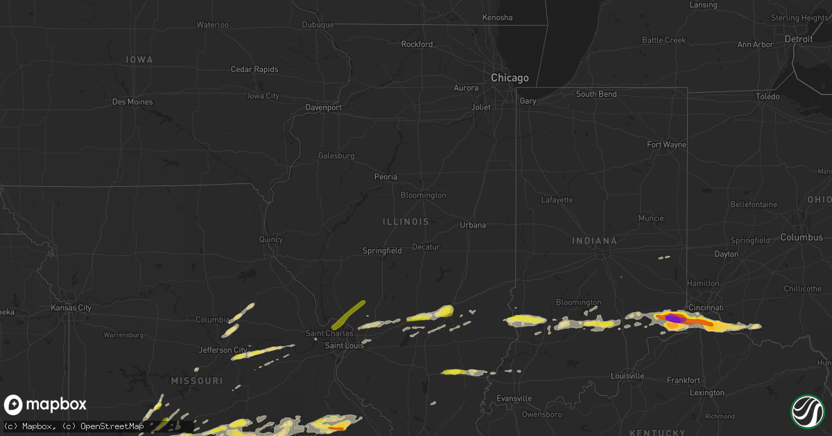
Hail Map in Illinois on October 19, 2016
Get this storm
October 19 map
$229
one time, instant access
Download today. No call, no setup
Keep the $229
Bought the map and want the full workflow? Apply the entire $229 to a subscription within 7 days. None of it is wasted.
Every map, not just this one
This buys you this map. Subscription and you get every map we run, in the markets you choose from a few cities to whole states to nationwide. Plus real-time alerts the moment a storm fires.
Contact data
Name, contact info, occupancy, even credit band for addresses in the footprint. You go from where it hit to who to call.
Become the source they trust
Unlimited branding weather history reports on demand. You already have the documented answer ready for the property owner, and you are the one who showed up with it.
Property data and RoofTrace estimates
Pull up any address you have got, its value and the exact code rules for that jurisdiction, straight from One Click Code. Then RoofTrace estimates the squares, pitch, and roof value, priced the way you price.
Storm reports in Illinois
Illinois
| Date | Description |
|---|---|
| 10/19/201612:16 AM CDT | Estimate of quarter size hail and ponding of water wihile driving |
| 10/18/20168:41 PM CDT | Swop report |
| 10/18/20168:40 PM CDT | A local report indicates 1.00 inch wind near EFFINGHAM |
| 10/18/20168:34 PM CDT | Quarter sized hail reported in keptown...relayed via wand-tv |
| 10/18/20168:30 PM CDT | Public report via ktvi-tv in st louis. |
| 10/18/20168:02 PM CDT | 8 inch diameter limb down in st. Elmo. Time estimated from radar. |
All States Impacted by Hail Map on October 19, 2016
Cities Impacted by Hail Map on October 19, 2016
- Vernon, TX
- Palestine, IL
- Brownstown, IL
- Mulberry Grove, IL
- Saint Elmo, IL
- Vandalia, IL
- Lyons, IN
- Oaktown, IN
- Flat Rock, IL
- Sandborn, IN
- Carlisle, IN
- Robinson, IL
- Merom, IN
- Linton, IN
- Wagoner, OK
- Comanche, OK
- Seymour, TX
- Throckmorton, TX
- Park Hills, MO
- Farmington, MO
- Arcadia, MO
- Sainte Genevieve, MO
- Ironton, MO
- Belleview, MO
- Pilot Knob, MO
- Doe Run, MO
- Middle Brook, MO
- Lesterville, MO
- Bismarck, MO
- Perryville, MO
- Fredericktown, MO
- Saint Mary, MO
- Gravette, AR
- Colcord, OK
- Jay, OK
- Saint Charles, MO
- O'Fallon, MO
- Dupont, IN
- Kingdom City, MO
- Mexico, MO
- Auxvasse, MO
- Martinsburg, MO
- Benton City, MO
- Dillsboro, IN
- Loose Creek, MO
- Linn, MO
- Bonnots Mill, MO
- Fort Worth, TX
- Haltom City, TX
- Patoka, IL
- Vernon, IL
- Arlington, TX
- Berger, MO
- New Haven, MO
- Lebanon, MO
- Falcon, MO
- Plato, MO
- Lynchburg, MO
- Laquey, MO
- Niangua, MO
- Carl Junction, MO
- Galena, KS
- Joplin, MO
- Webb City, MO
- Long Lane, MO
- Moscow, OH
- California, KY
- Newton, IL
- Ingraham, IL
- Dieterich, IL
- Mason, IL
- Effingham, IL
- Watson, IL
- Altamont, IL
- Alexandria, KY
- Hermitage, MO
- Boss, MO
- Bixby, MO
- Norman, IN
- Heltonville, IN
- Newburg, MO
- Edgar Springs, MO
- Duke, MO
- Beulah, MO
- Ash Grove, MO
- Walnut Grove, MO
- Willard, MO
- Latonia, KY
- Union, KY
- Morning View, KY
- Walton, KY
- Butler, KY
- Independence, KY
- Patriot, IN
- Petersburg, KY
- Versailles, IN
- Holton, IN
- Warsaw, KY
- Georgetown, OH
- Ft Mitchell, KY
- Felicity, OH
- Aurora, IN
- De Mossville, KY
- Burlington, KY
- Rising Sun, IN
- Florence, KY
- Canaan, IN
- Erlanger, KY
- Neville, OH
- Foster, KY
- Florence, IN
- Madison, IN
- Vevay, IN
- Bethel, OH
- Milan, IN
- Cross Plains, IN
- Moores Hill, IN
- New Richmond, OH
- Hamersville, OH
- Bennington, IN
- Medora, IN
- Brownstown, IN
- Salem, MO
- Licking, MO
- Byars, OK
- Wanette, OK
- Asher, OK
- Williams, IN
- Bedford, IN
- Bloomfield, IN
- Owensburg, IN
- Crane, IN
- Springville, IN
- Wetumka, OK
- Konawa, OK
- Maud, OK
- Sasakwa, OK
- Strafford, MO
- Seymour, MO
- Rogersville, MO
- Marshfield, MO
- Houston, MO
- Theodosia, MO
- Healdton, OK
- Everton, MO
- Jadwin, MO
- Sorento, IL
- Hamel, IL
- New Douglas, IL
- Greenville, IL
- Edwardsville, IL
- Highland, IL
- Worden, IL
- Pocahontas, IL
- Alhambra, IL
- Elnora, IN
- Montgomery, IN
- Odon, IN
- Flemington, MO
- Bolivar, MO
- Polk, MO
- Urbana, MO
- Pittsburg, MO
- Preston, MO
- Half Way, MO
- Buffalo, MO
- Wayne City, IL
- Fairfield, IL
- Thompsonville, IL
- West Frankfort, IL
- Winchester, OH
- Russellville, OH
- Butlerville, IN
- Ripley, OH
- West Union, OH
- North Vernon, IN
- Seymour, IN
- Verona, KY
- Vernon, IN
- Lawton, OK
- Lamar, MO
- Ashland, MO
- Fulton, MO
- New Bloomfield, MO
- Aspermont, TX
- Fair Grove, MO
- Holdenville, OK
- Commiskey, IN
- Hermann, MO
- Raymondville, MO
- Pryor, OK
- Wichita Falls, TX
- Eldon, MO
- Valley View, TX
- Muenster, TX
- Gainesville, TX
- Wyandotte, OK
- Gentry, AR
- Rogers, AR
- Lowell, AR
- Cave Springs, AR
- Bentonville, AR
- Dustin, OK
- Bland, MO
- Saint Jo, TX
- Catoosa, OK
- Claremore, OK
- Tulsa, OK
- Chamois, MO
- Morrison, MO
- Old Glory, TX
- Sheppard Afb, TX
- Munday, TX
- Conway, MO
- Richland, MO
- Watts, OK
- Carthage, MO
- Jasper, MO
- Aurora, MO
- Cassville, MO
- Tecumseh, OK
- Shawnee, OK
- Powell, MO
- Grand Prairie, TX
- Salina, OK
- Springfield, MO
- Prague, OK
- Paden, OK
- Louisville, IL
- Okemah, OK
- Phillipsburg, MO
- Plainville, IN
- Washington, IN
- Goree, TX
- Weinert, TX
- Chouteau, OK
- Locust Grove, OK
- Temple, OK
- Bunker, MO
- Neosho, MO
- Goodman, MO
- Seneca, MO
- Stratford, OK
- Springdale, AR
- Fairland, OK
- Grove, OK
- Ellery, IL
- Golden Gate, IL
- Union Center, SD
- Owensville, MO
- Fordland, MO
- Freetown, IN
- Jefferson City, MO
- Roff, OK
- Fitzhugh, OK
- Ada, OK
- Rosebud, MO
- Kansas, OK
- Woodson, TX
- Bucyrus, MO
- Keenes, IL
- Albion, IL
- Barnhill, IL
- Opdyke, IL
- Grayville, IL
- Collinsville, IL
- O'Fallon, IL
- Troy, IL
- Calvin, OK
- Stuart, OK
- Hartville, MO
- Grovespring, MO
- Roby, MO
- Waurika, OK
- Nashville, IN
- Success, MO
- Henrietta, TX
- Keyesport, IL
- Smithboro, IL
- Mcalester, OK
- Lamar, OK
- Mount Carmel, IL
- Meeker, OK
- Rush Springs, OK
- Marlow, OK
- Pauls Valley, OK
- Lexington, OK
- Hanna, OK
- Lenox, MO
- Rolla, MO
- Connersville, IN
- Falmouth, IN
- Tunas, MO
- Windyville, MO
- Elkland, MO
- Edgewood, IL
- Farina, IL
- Kinmundy, IL
- Ryan, OK
- Mcloud, OK
- Rose, OK
- Bloomington, IN
- Shobonier, IL
- Crowell, TX
- Leslie, MO
- Vienna, MO
- Westphalia, MO
- Macks Creek, MO
- Milton, IN
- Marthasville, MO
- Seminole, OK
- Isabella, MO
- Thornfield, MO
- Broken Arrow, OK
- Sullivan, IN
- Eldridge, MO
- Knox City, TX
- Lockwood, MO
- Fort Leonard Wood, MO
- Brighton, MO
- Pleasant Hope, MO
- Black, MO
- Davisville, MO
- Miller, MO
- Viburnum, MO
- Graham, OK
- Ratliff City, OK
- Hulbert, OK
- Noble, OK
- Mountain Grove, MO
- Lewellen, NE
- Paris Crossing, IN
- Crothersville, IN
- Princeton, IN
- Francisco, IN
- Dixon, MO
- Wynnewood, OK
- Brookline, MO
- Brule, NE
- Exeter, MO
- Wewoka, OK
- Weleetka, OK
- Shelbyville, IN
- Owensville, IN
- Ringling, OK
- Oronogo, MO
- Tahlequah, OK
- Twin Oaks, OK
- Oaks, OK
- Hastings, OK
- Peggs, OK
- Inola, OK
- Protem, MO
- Westville, OK
- Proctor, OK
- Coweta, OK
- Porter, OK
- Cross Timbers, MO
- Aldrich, MO
- Gerald, MO
- Wheeler, IL
- Potosi, MO
- Oolitic, IN
- Avoca, IN
- Vallonia, IN
- Loogootee, IN
- Lone Grove, OK
- Wilson, OK
- Davidson, OK
- Lindsay, TX
- Morrisville, MO
- Edwardsport, IN
- Duncan, OK
- Walters, OK
- Springer, OK
- Bunker Hill, IL
- Ramsey, IL
- Dahlgren, IL
- Godfrey, IL
- Florissant, MO
- Dow, IL
- Elsah, IL
- Portage Des Sioux, MO
- Brighton, IL
- Shipman, IL
- Jerseyville, IL
- West Alton, MO
- Sulphur Springs, AR


