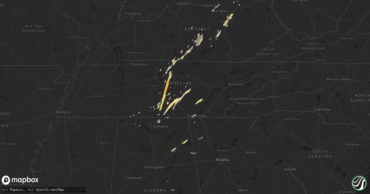
Hail Map in Tennessee on October 18, 2011
Get this storm
October 18 map
$229
one time, instant access
Download today. No call, no setup
Keep the $229
Bought the map and want the full workflow? Apply the entire $229 to a subscription within 7 days. None of it is wasted.
Every map, not just this one
This buys you this map. Subscription and you get every map we run, in the markets you choose from a few cities to whole states to nationwide. Plus real-time alerts the moment a storm fires.
Contact data
Name, contact info, occupancy, even credit band for addresses in the footprint. You go from where it hit to who to call.
Become the source they trust
Unlimited branding weather history reports on demand. You already have the documented answer ready for the property owner, and you are the one who showed up with it.
Property data and RoofTrace estimates
Pull up any address you have got, its value and the exact code rules for that jurisdiction, straight from One Click Code. Then RoofTrace estimates the squares, pitch, and roof value, priced the way you price.
Storm reports in Tennessee
Tennessee
| Date | Description |
|---|---|
| 10/18/20114:50 PM CDT | Report of trees down on north side of pulaski with power outages. Time estimated based on radar. |
| 10/18/20113:48 PM CDT | Power line blown down in roadway and hail of unknown size reported |
| 10/18/20113:39 PM CDT | A local report indicates 1.00 inch wind near 10 S LEBANON |
| 10/18/20113:26 PM CDT | A local report indicates 1.75 inch wind near 2 ESE WALTERHILL |
| 10/18/20113:25 PM CDT | A local report indicates 1.75 inch wind near MURFREESBORO |
| 10/18/20113:25 PM CDT | A local report indicates 1.75 inch wind near MANCHESTER |
| 10/18/20113:20 PM CDT | Two trees blown down and windows broken out in homes... With alarms going off. |
| 10/18/20113:20 PM CDT | A local report indicates 1.25 inch wind near MANCHESTER |
| 10/18/20113:20 PM CDT | A local report indicates 65 MPH wind near 3 N MURFREESBORO |
| 10/18/20113:20 PM CDT | Hail covered the ground |
| 10/18/20113:15 PM CDT | A local report indicates 1.75 inch wind near MURFREESBORO |
| 10/18/20113:10 PM CDT | Reported at barfield. Also...local tv station has pictures of tennis ball sized hail in rutherford county area. |
| 10/18/20113:10 PM CDT | A local report indicates 1.75 inch wind near MURFREESBORO |
| 10/18/20113:06 PM CDT | Reported in rocky mount |
| 10/18/20113:05 PM CDT | A local report indicates 1.00 inch wind near TULLAHOMA |
| 10/18/20113:05 PM CDT | Quarter size hail reported at west middle school. |
| 10/18/20113:00 PM CDT | The hail produced lots of damage to cars and roofs |
| 10/18/20112:58 PM CDT | Public reported hail up to golfball size near shelbyville. Time and location estimated based on radar. |
| 10/18/20112:54 PM CDT | Penny to quarter size hail up to one half of an inch deep was reported covering the road at this location. |
| 10/18/20112:54 PM CDT | Penny to quarter size hail was reported covering the road on tankeysville ridge road. |
| 10/18/20112:50 PM CDT | Penny to quarter size hail was reported covering ed sanders road up to one half inch deep. |
| 10/18/20112:48 PM CDT | Penny to quarter size hail was reported covering the road on lost creek road. |
| 10/18/20112:43 PM CDT | Golfball -- or larger -- hail reported on minusa road. |
All States Impacted by Hail Map on October 18, 2011
Cities Impacted by Hail Map on October 18, 2011
- Kellyton, AL
- Equality, AL
- Alexander City, AL
- Owingsville, KY
- Lafayette, TN
- Westmoreland, TN
- Nancy, KY
- Liberty, KY
- Paint Lick, KY
- Richmond, KY
- Waco, KY
- Irvine, KY
- Winchester, KY
- Berea, KY
- Wartrace, TN
- Normandy, TN
- Manchester, TN
- Mcminnville, TN
- Hillsboro, TN
- Morrison, TN
- New Hope, KY
- Raywick, KY
- Murfreesboro, TN
- Lascassas, TN
- Lebanon, TN
- Christiana, TN
- Carlisle, KY
- Doyle, TN
- Belvidere, TN
- Estill Springs, TN
- Kelso, TN
- Tullahoma, TN
- Mulberry, TN
- Winchester, TN
- Rock Island, TN
- Lynchburg, TN
- Harvest, AL
- Huntsville, AL
- Toney, AL
- Meridianville, AL
- Hazel Green, AL
- Knifley, KY
- Rockford, AL
- Shelbyville, TN
- Watertown, TN
- Bell Buckle, TN
- Adolphus, KY
- Scottsville, KY
- Elk Horn, KY
- Campbellsville, KY
- Petersburg, TN
- Fayetteville, TN
- Waynesburg, KY
- Eubank, KY
- Crab Orchard, KY
- Brodhead, KY
- Columbia, KY
- Castalian Springs, TN
- Bethpage, TN
- Holland, KY
- Fort Payne, AL
- Cedar Bluff, AL
- Collinsville, AL
- Leesburg, AL
- Gaylesville, AL
- Chattanooga, TN
- Edmonton, KY
- Dayton, TN
- Graysville, TN
- Bradfordsville, KY
- Gravel Switch, KY
- Attalla, AL
- Fountain Run, KY
- Gamaliel, KY
- Mount Sterling, KY
- Dunnville, KY
- New Market, AL
- Elora, TN
- Versailles, KY
- Hendersonville, TN
- Stanford, KY
- Russell Springs, KY
- Greensburg, KY
- Sylacauga, AL
- Belfast, TN
- Dunlap, TN
- Sale Creek, TN
- Whiteside, TN
- Tompkinsville, KY
- Burkesville, KY
- Pulaski, TN
- Mannsville, KY
- Leoma, TN
- Loretto, TN
- Beaumont, KY
- Summer Shade, KY
- Calhoun, GA
- Gallant, AL
- Cornersville, TN
- Taft, TN
- Hartsville, TN
- Moorefield, KY
- Town Creek, AL
- Rogersville, AL
- Gadsden, AL
- Cedartown, GA
- Piedmont, AL
- Iron City, TN
- Readyville, TN
- Milton, TN
- Mount Hermon, KY
- Mount Juliet, TN
- Gallatin, TN
- Sparta, TN
- Eagleville, TN
- Chapel Hill, TN
- Rockvale, TN
- Cookeville, TN
- Bradyville, TN
- Wildwood, GA
- Bethelridge, KY
- Yosemite, KY
- Rome, GA
- Plainville, GA
- Smithville, TN
- Frankewing, TN
- Eighty Eight, KY
- Glasgow, KY
- Georgetown, KY
- Lexington, KY
- Midway, KY
- Tremont, MS
- Greenwood Springs, MS
- Monticello, KY
- Chickamauga, GA
- Muscle Shoals, AL
- Breeding, KY
- Quebeck, TN
- Flintville, TN


