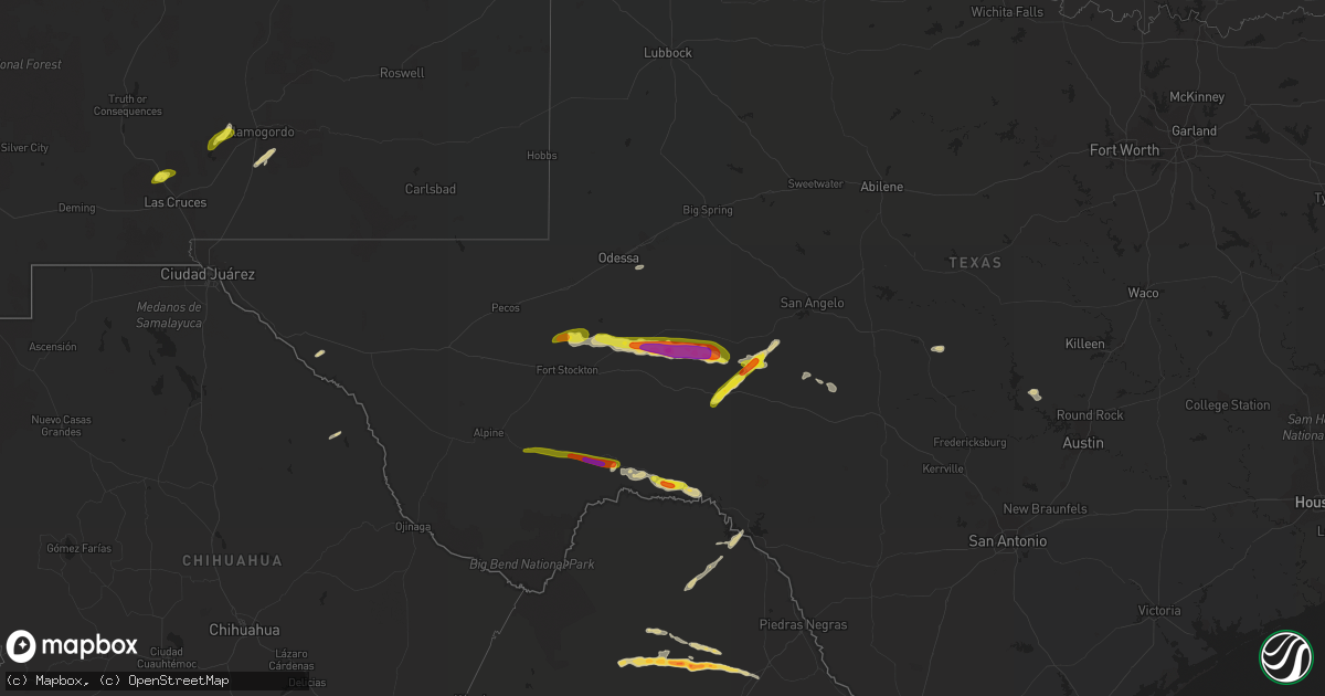
Hail Map on October 16, 2022
Get this storm
October 16 map
$229
one time, instant access
Download today. No call, no setup
Keep the $229
Bought the map and want the full workflow? Apply the entire $229 to a subscription within 7 days. None of it is wasted.
Every map, not just this one
This buys you this map. Subscription and you get every map we run, in the markets you choose from a few cities to whole states to nationwide. Plus real-time alerts the moment a storm fires.
Contact data
Name, contact info, occupancy, even credit band for addresses in the footprint. You go from where it hit to who to call.
Become the source they trust
Unlimited branding weather history reports on demand. You already have the documented answer ready for the property owner, and you are the one who showed up with it.
Property data and RoofTrace estimates
Pull up any address you have got, its value and the exact code rules for that jurisdiction, straight from One Click Code. Then RoofTrace estimates the squares, pitch, and roof value, priced the way you price.
States Impacted by Hail Map on October 16, 2022
Storm reports
Arizona
| Date | Description |
|---|---|
| 10/16/20227:52 AM CDT | At 1252 AM MST, a severe thunderstorm was located over Salt River Indian Community, or 7 miles southeast of Paradise Valley, moving northwest at 20 mph. HAZARD...Quarter size hail. SOURCE...Radar indicated. IMPACT...Damage to vehicles is expected. Locations impacted include... Phoenix, Mesa, Scottsdale, Paradise Valley, Mesa Riverview Mall, Piestewa Peak Park, Downtown Scottsdale, Salt River Indian Community, Downtown Mesa, Scottsdale Airport, Camelback Mountain and North Mountain Park.This includes the following highways...AZ Route 51 between mile markers 5 and 13.AZ Route 87 between mile markers 173 and 182.AZ Route 202 between mile markers 10 and 17. |
| 10/15/202210:10 PM CDT | At 310 PM MST, a severe thunderstorm was located over Sun Lakes, moving south at 10 mph. HAZARD...60 mph wind gusts and quarter size hail. SOURCE...Radar indicated. IMPACT...Hail damage to vehicles is expected. Expect wind damage to roofs, siding, and trees. Locations impacted include... Sun Lakes, Olberg, Bapchule, Santan and Sacaton. This includes the following highways...AZ Interstate 10 between mile markers 166 and 180.AZ Route 87 between mile markers 158 and 160.AZ Route 347 between mile markers 177 and 180. |
| 10/15/20229:14 PM CDT | At 214 AM MST, a severe thunderstorm was located near Chandler Fashion Center Mall, or near Chandler, moving northwest at 25 mph. HAZARD...Quarter size hail. SOURCE...Radar indicated. IMPACT...Damage to vehicles is expected. Locations impacted include... Phoenix, Chandler, Tempe, Paradise Valley, Laveen, Sun Lakes, Papago Park, Piestewa Peak Park, Arizona Mills Mall, Tumbleweed Park, South Phoenix, Arizona State Fairgrounds, Chandler City Hall, South Mountain Park and Downtown Phoenix.This includes the following highways...AZ Interstate 10 between mile markers 140 and 169.AZ Interstate 17 between mile markers 195 and 203.AZ Route 51 between mile markers 1 and 6. |
| 10/15/20228:36 PM CDT | At 136 AM MST, a severe thunderstorm was located near Bapchule, or near Sun Lakes, moving northwest at 15 mph. HAZARD...Quarter size hail. SOURCE...Radar indicated. IMPACT...Damage to vehicles is expected. Locations impacted include... Chandler, Gilbert, Sun Lakes, Bapchule, Tumbleweed Park, Olberg, Chandler Fashion Center Mall, Chandler City Hall, Gilbert City Hall, Firebird Lake, Santan and Sacaton.This includes the following highways...AZ Interstate 10 between mile markers 161 and 179.AZ Route 87 between mile markers 151 and 170.AZ Route 202 between mile markers 43 and 55. |
New Mexico
| Date | Description |
|---|---|
| 10/16/20223:30 PM CDT | Military meteorologist reported quarter sized hail at i-25 mile marker 21. Interstate covered with hail from mile marker 20 to mile marker 25. |
| 10/16/202210:13 AM CDT | Hail the size of quarters fell for several minutes. |
| 10/15/202211:19 PM CDT | At 418 PM MDT, a severe thunderstorm was located 4 miles northwest of White Sands National Monument, moving northeast at 20 mph. HAZARD...Quarter size hail. SOURCE...Radar indicated. IMPACT...Damage to vehicles is expected. Locations impacted include... Alamogordo, White Sands National Monument, Holloman Air Force Base, Boles Acres and Lake Lucero.This includes the following highways... Highway 70 in New Mexico between mile markers 199 and 212. Highway 54 in New Mexico between mile markers 61 and 64. |
| 10/15/20229:26 PM CDT | At 226 PM MDT, a severe thunderstorm was located 6 miles northeast of Radium Springs, moving northeast at 60 mph. HAZARD...60 mph wind gusts and quarter size hail. SOURCE...Radar indicated. IMPACT...Hail damage to vehicles is expected. Expect wind damage to roofs, siding, and trees. Locations impacted include... Leasburg, Jornada Range, Radium Springs, Portions of Jornada Experimental Range, Fort Selden State Historic Site and Leasburg Dam State Park.This includes Interstate 25 in New Mexico between mile markers 14 and29. |
Texas
| Date | Description |
|---|---|
| 10/16/20222:54 AM CDT | At 753 PM CDT, a severe thunderstorm was located near The Intersection Of Us-190 And Ranch Road 1828, or 15 miles west of Eldorado, moving east at 30 mph. HAZARD...60 mph wind gusts and quarter size hail. SOURCE...Radar indicated. IMPACT...Hail damage to vehicles is expected. Expect wind damage to roofs, siding, and trees. This severe thunderstorm will be near... Eldorado around 825 PM CDT.Other locations impacted by this severe thunderstorm include Us-190 Near The Crockett-Sutton County Line, The Intersection Of Ranch Road 1828 And RanchRoad 915 and The Intersection Of Us-190 And Ranch Road 1828. |
| 10/16/20221:51 AM CDT | At 650 PM CDT, a severe thunderstorm was located 12 miles south of Big Lake, moving east at 35 mph. HAZARD...70 mph wind gusts and ping pong ball size hail. SOURCE...Radar indicated. IMPACT...People and animals outdoors will be injured. Expect hail damage to roofs, siding, windows, and vehicles. Expect considerable tree damage. Wind damage is also likely to mobile homes, roofs, and outbuildings. This severe thunderstorm will remain over mainly rural areas of northeastern Crockett County, including the following locations... The Intersection Of Us 190 And Highway 163 and Us-190 Near The Crockett-Sutton County Line. |
| 10/16/20221:12 AM CDT | At 607 PM CDT, a severe thunderstorm was located 10 miles north of Iraan, moving east at 35 mph. HAZARD...Golf ball size hail and 70 mph wind gusts. SOURCE...Radar indicated. IMPACT...People and animals outdoors will be injured. Expect hail damage to roofs, siding, windows, and vehicles. Expect considerable tree damage. Wind damage is also likely to mobile homes, roofs, and outbuildings. This severe thunderstorm will remain over mainly rural areas of north central Crockett County. |
| 10/16/202212:32 AM CDT | At 531 PM CDT, a severe thunderstorm was located over Upton County Airport, or near McCamey, moving east at 20 mph. HAZARD...60 mph wind gusts and quarter size hail. SOURCE...Radar indicated. IMPACT...Hail damage to vehicles is expected. Expect wind damage to roofs, siding, and trees. This severe thunderstorm will remain over mainly rural areas of northwestern Crockett County. |
| 10/15/20228:07 PM CDT | At 106 AM CDT, a severe thunderstorm was located 9 miles west of Hart, moving northeast at 20 mph. HAZARD...70 mph wind gusts. SOURCE...Radar indicated. IMPACT...Expect considerable tree damage. Damage is likely to mobile homes, roofs, and outbuildings. Locations impacted include... Dimmitt, Hart, Earth and Springlake. |
Oklahoma
| Date | Description |
|---|---|
| 10/16/20227:36 AM CDT | At 1235 AM CDT, severe thunderstorms were located along a line extending from 3 miles northeast of Boone to 4 miles northeast of Lake Lawtonka to near Fort Sill, moving east at 35 mph. HAZARD...60 mph wind gusts and quarter size hail. SOURCE...Trained weather spotters reported quarter size hail south of Meers. IMPACT...Hail damage to vehicles is expected. Expect wind damage to roofs, siding, and trees. Locations impacted include... Northern Lawton, Elgin, Apache, Fletcher, Cyril, Sterling, Cement, Medicine Park, Meers, Lake Lawtonka, Boone, Fort Sill, Lake Ellsworth, Wichita Mountains Wildlife Refuge and Stecker. |