Hail Map in Texas on October 14, 2026
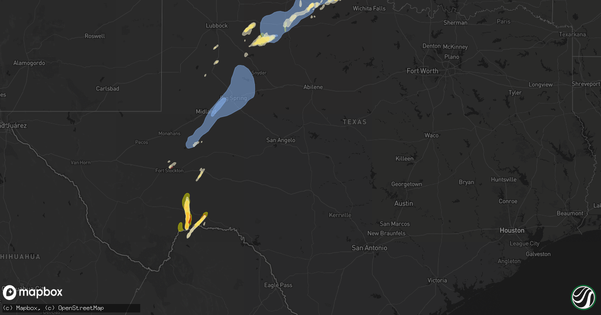
Get this storm
October 14 map
$229
one time, instant access
Download today. No call, no setup
Keep the $229
Bought the map and want the full workflow? Apply the entire $229 to a subscription within 7 days. None of it is wasted.
Every map, not just this one
This buys you this map. Subscription and you get every map we run, in the markets you choose from a few cities to whole states to nationwide. Plus real-time alerts the moment a storm fires.
Contact data
Name, contact info, occupancy, even credit band for addresses in the footprint. You go from where it hit to who to call.
Become the source they trust
Unlimited branding weather history reports on demand. You already have the documented answer ready for the property owner, and you are the one who showed up with it.
Property data and RoofTrace estimates
Pull up any address you have got, its value and the exact code rules for that jurisdiction, straight from One Click Code. Then RoofTrace estimates the squares, pitch, and roof value, priced the way you price.
Storm reports in Texas
Texas
| Date | Description |
|---|---|
| 10/14/20266:56 PM CDT | A local report indicates 60 MPH wind near 3 NW Knox City |
| 10/14/20266:00 PM CDT | A local report indicates 59 MPH wind near 10 WSW Guthrie |
| 10/14/20265:35 PM CDT | Sheet metal blown off of barns wrapped. |
| 10/14/20265:25 PM CDT | Branches several inches in diameter blown off of multiple large mesquite trees. |
| 10/14/20265:23 PM CDT | Roof blown off of a house. Time estimated. |
| 10/14/20264:47 PM CDT | A local report indicates 62 MPH wind near 1 SSE Lomax |
| 10/14/20264:43 PM CDT | Trained spotter measured 70-75 mph wind gusts with a handheld anemometer. |
| 10/14/20264:43 PM CDT | Trained spotter reported a dumpster and a utility sign blown over and approximately 2 1/2 in diameter tree branches downed on west side drive in stanton. Also reported |
| 10/14/20264:43 PM CDT | Trained spotter reported a tree down over convent st at the intersection of south convent st and east saint elizabeth st. |
| 10/14/20264:20 PM CDT | Em reported multiple power lines down across the road near 2509 scr 1150. |
| 10/14/20264:20 PM CDT | Em reported down power lines a 1301 s county rd 1082. |
| 10/14/20264:20 PM CDT | Em reported down power lines at 6105 s county rd 1178. |
| 10/14/20263:38 PM CDT | Crane mesonet site measured a 64 mph wind gust. |
| 10/14/20263:07 PM CDT | Report from mping: golf ball |
| 10/14/20262:29 PM CDT | Trained spotter and pecos county em reported a tornado ne of fort stockton. Preliminary reports of damage. |
| 10/14/20262:24 PM CDT | Corrects previous tornado report from 3 ne fort stockton. Trained spotter and pecos county em reported a tornado ne of fort stockton. The tornado pulled metal wall pane |
| 10/14/20262:18 PM CDT | Emergency management reported a brief tornado touched down in fort stockton near the intersection of ryan and young streets. The tornado tracked past the pecos county c |
| 10/13/20268:50 PM CDT | Uprooted large tree. Time estimated by radar. |
| 10/13/20268:10 PM CDT | A local report indicates 60 MPH wind near 4 SE Oklaunion |
| 10/13/20267:19 PM CDT | Delayed storm report. |
Cities Impacted by Hail Map on October 14, 2026
- Hopedale, OH
- Jewett, OH
- Paducah, TX
- Fort Stockton, TX
- Imperial, TX
- Seymour, TX
- Crowell, TX
- Ralls, TX
- Crosbyton, TX
- Lamesa, TX
- Crane, TX
- McCamey, TX
- Tahoka, TX
- Dickens, TX
- Spur, TX
- Odessa, TX
- Midkiff, TX
- Midland, TX
- Goshen, OH
- Morrow, OH
- Loveland, OH
- Pleasant Plain, OH
- Blanchester, OH
- Clarksville, OH
- Midland, OH
- Marathon, TX
- Vernon, TX
- Oak Hill, OH
- Thurman, OH
- Gallipolis, OH
- Rio Grande, OH
- Bidwell, OH
- Dryden, TX
- Stanton, TX
- Garden City, TX
- Big Spring, TX
- Post, TX
- Justiceburg, TX
- Iraan, TX
- Knott, TX
- Coahoma, TX
- Gail, TX
- Snyder, TX
- Girard, TX
- Westbrook, TX
- Jayton, TX
- Afton, TX
- Aspermont, TX
- Harrold, TX
- Oklaunion, TX
- Davidson, OK
- Fluvanna, TX
- Ira, TX
- Colorado City, TX
- Walters, OK
- Chattanooga, OK
- Faxon, OK
- Cache, OK
- Quanah, TX
- Chillicothe, TX
- Frederick, OK
- Elmer, OK
- Tipton, OK
- Loveland, OK
- Randlett, OK
- Electra, TX
- Burkburnett, TX
- Hollister, OK
- Devol, OK
- Iowa Park, TX
- Grandfield, OK
- Geronimo, OK
- Lawton, OK
- Indiahoma, OK
- Temple, OK
- Waurika, OK
- Hastings, OK
- Duncan, OK
- Comanche, OK
- Byers, TX
- Ryan, OK
- Wilson, OK
- Ringling, OK
- Marlow, OK
- Loco, OK
- Tussy, OK
- Elmore City, OK
- Graham, OK
- Healdton, OK
- Rush Springs, OK
- Ratliff City, OK
- Lindsay, OK
- Foster, OK
- Hennepin, OK
- Springer, OK
- Pauls Valley, OK
- Ardmore, OK
- Wynnewood, OK
- Paoli, OK
- Maysville, OK
- Wayne, OK
- Lone Grove, OK
- Lexington, OK
- Purcell, OK
- Davis, OK
- Byars, OK
- Stratford, OK
- Sulphur, OK
- Wanette, OK
- Asher, OK
- Maud, OK
- Norman, OK
- Macomb, OK
- Shawnee, OK
- Bowlegs, OK
- Noble, OK
- Konawa, OK
- Seminole, OK
- Tecumseh, OK
- Wewoka, OK
- Earlsboro, OK
- Ada, OK
- Prague, OK
- Okemah, OK
- Paden, OK
- Boley, OK
- Wetumka, OK
- Holdenville, OK
- Weleetka, OK
- Castle, OK


