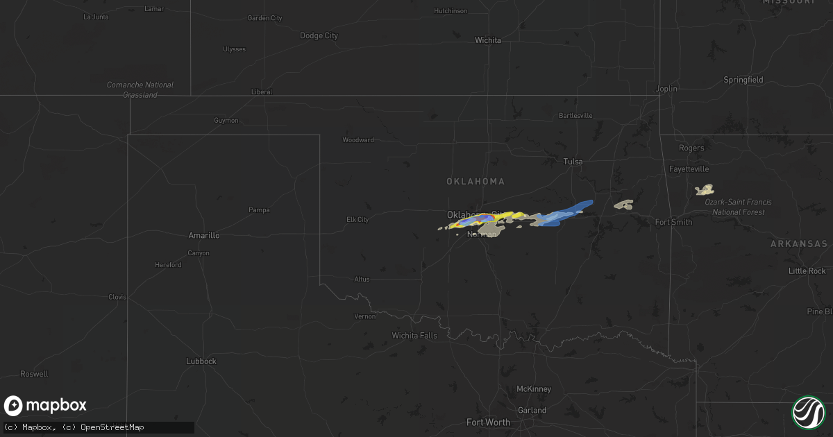
Hail Map in Oklahoma on October 14, 2021
Get this storm
October 14 map
$229
one time, instant access
Download today. No call, no setup
Keep the $229
Bought the map and want the full workflow? Apply the entire $229 to a subscription within 7 days. None of it is wasted.
Every map, not just this one
This buys you this map. Subscription and you get every map we run, in the markets you choose from a few cities to whole states to nationwide. Plus real-time alerts the moment a storm fires.
Contact data
Name, contact info, occupancy, even credit band for addresses in the footprint. You go from where it hit to who to call.
Become the source they trust
Unlimited branding weather history reports on demand. You already have the documented answer ready for the property owner, and you are the one who showed up with it.
Property data and RoofTrace estimates
Pull up any address you have got, its value and the exact code rules for that jurisdiction, straight from One Click Code. Then RoofTrace estimates the squares, pitch, and roof value, priced the way you price.
Storm reports in Oklahoma
Oklahoma
| Date | Description |
|---|---|
| 10/14/20216:45 AM CDT | At 1145 PM CDT, a severe thunderstorm was located 5 miles northwest of Tuttle, moving northeast at 30 mph. HAZARD...60 mph wind gusts and quarter size hail. SOURCE...Radar indicated. IMPACT...Hail damage to vehicles is expected. Expect wind damage to roofs, siding, and trees. Locations impacted include... Southwestern Oklahoma City, Moore, Newcastle, Yukon, Bethany, Mustang, Warr Acres, The Village, Tuttle, Nichols Hills, Union City, Minco, Valley Brook and Woodlawn Park. |
| 10/14/20214:20 AM CDT | Large tree limb broken on dwight mission road. Relayed via twitter. |
| 10/14/20213:26 AM CDT | A local report indicates 61 MPH wind near CHECOTAH |
| 10/14/20211:18 AM CDT | A local report indicates 1.25 inch wind near MEEKER |
| 10/14/202112:32 AM CDT | A local report indicates 70 MPH wind near 1 E DEL CITY |
| 10/14/202112:30 AM CDT | Main area of damage between se 15th street and e reno ave near the high school. Numerous large tree limbs downed... Sheet metal roofing peeled off of a shopping center. |
| 10/14/202112:30 AM CDT | Power poles down... Trees uprooted. |
| 10/14/202112:29 AM CDT | A local report indicates 1.75 inch wind near 2 ESE VALLEY BROOK |
| 10/14/202112:26 AM CDT | With est 65 mph gusts. |
| 10/14/202112:25 AM CDT | With one-inch hail. |
| 10/14/202112:20 AM CDT | Windows destroyed and roof removed from building... Found 100yds away. |
| 10/14/202112:20 AM CDT | Evidence from images provided by our media partners... Details from emergency management... Radar data... And an on-site nws survey suggests strong evidence of an inten |
| 10/14/202112:20 AM CDT | A local report indicates 1.75 inch wind near 4 WSW VALLEY BROOK |
| 10/14/202112:15 AM CDT | Power pole down. |
| 10/14/202112:15 AM CDT | Delayed report. The most concentrated area of damage extends from the west side of will rogers world airport to the 2100-2800 block of s. Western ave. This includes pow |
| 10/14/202112:13 AM CDT | A local report indicates 70 MPH wind near 6 E MUSTANG |
| 10/14/202112:13 AM CDT | Damage to hanger at will rogers airport. |
| 10/14/202112:10 AM CDT | A local report indicates 68 MPH wind near 6 E MUSTANG |
| 10/14/202112:03 AM CDT | A local report indicates 1.25 inch wind near 1 E MUSTANG |
| 10/14/202112:00 AM CDT | A local report indicates 1.00 inch wind near 1 SW MUSTANG |
| 10/14/202112:00 AM CDT | A local report indicates 65 MPH wind near 3 S MUSTANG |
| 10/13/202111:55 PM CDT | A local report indicates 60 MPH wind near 5 NNE TUTTLE |
Cities Impacted by Hail Map on October 14, 2021
- Prague, OK
- Meeker, OK
- Shawnee, OK
- Oklahoma City, OK
- Combs, AR
- Elkins, AR
- Ozark, AR
- Winslow, AR
- Henryetta, OK
- Newalla, OK
- Mcloud, OK
- Choctaw, OK
- Tuttle, OK
- Minco, OK
- Union City, OK
- Mustang, OK
- Wheatland, OK
- Okemah, OK
- Earlsboro, OK
- Newcastle, OK
- Norman, OK
- Gore, OK
- Harrah, OK
- Mountainburg, AR
- Saint Paul, AR
- Paden, OK
- Anadarko, OK
- Braggs, OK
- Muskogee, OK
- Warner, OK
- Vian, OK
- Seminole, OK
- Weleetka, OK
- Tecumseh, OK
- Wewoka, OK
- Castle, OK
- Okmulgee, OK
- Boley, OK
- Boynton, OK
- Council Hill, OK
- Morris, OK


