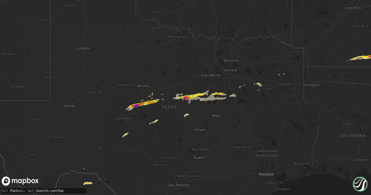
Hail Map on October 14, 2018
Get this storm
October 14 map
$229
one time, instant access
Download today. No call, no setup
Keep the $229
Bought the map and want the full workflow? Apply the entire $229 to a subscription within 7 days. None of it is wasted.
Every map, not just this one
This buys you this map. Subscription and you get every map we run, in the markets you choose from a few cities to whole states to nationwide. Plus real-time alerts the moment a storm fires.
Contact data
Name, contact info, occupancy, even credit band for addresses in the footprint. You go from where it hit to who to call.
Become the source they trust
Unlimited branding weather history reports on demand. You already have the documented answer ready for the property owner, and you are the one who showed up with it.
Property data and RoofTrace estimates
Pull up any address you have got, its value and the exact code rules for that jurisdiction, straight from One Click Code. Then RoofTrace estimates the squares, pitch, and roof value, priced the way you price.
Storm reports
Missouri
| Date | Description |
|---|---|
| 10/14/20185:38 AM CDT | At 1037 PM CDT, a severe thunderstorm was located 3 miles south of Hartville, or 12 miles west of Mountain Grove, moving east at 55 mph. HAZARD...Quarter size hail. SOURCE...Radar indicated. IMPACT...Damage to vehicles is expected. Locations impacted include... Houston... Dawson... Huggins... Solo... Bucyrus... Simmons... Bendavis... |
Arkansas
| Date | Description |
|---|---|
| 10/14/20186:55 PM CDT | A tree was blown down across ar highway 133 near county road 95. A few additional trees were blown down along county roads in the milo area. |
| 10/14/20182:49 AM CDT | At 749 PM CDT, a severe thunderstorm was located over Montrose, or 11 miles west of Lake Village, moving east at 25 mph. HAZARD...60 mph wind gusts and half dollar size hail. SOURCE...Radar indicated. IMPACT...Hail damage to vehicles is expected. Expect wind damage to roofs, siding, and trees. This severe thunderstorm will be near... Lake Village and Mcmillan Corner around 815 PM CDT. |
| 10/14/20182:11 AM CDT | At 711 PM CDT, a severe thunderstorm was located near Hamburg, moving east at 25 mph. HAZARD...60 mph wind gusts and quarter size hail. SOURCE...Radar indicated. IMPACT...Hail damage to vehicles is expected. Expect wind damage to roofs, siding, and trees. This severe thunderstorm will be near... Snyder around 730 PM CDT. Portland around 740 PM CDT. Montrose around 745 PM CDT. |
| 10/14/20181:33 AM CDT | At 633 PM CDT, a severe thunderstorm was located 8 miles northwest of West Crossett, moving east at 30 mph. HAZARD...60 mph wind gusts and quarter size hail. SOURCE...Radar indicated. IMPACT...Hail damage to vehicles is expected. Expect wind damage to roofs, siding, and trees. This severe thunderstorm will be near... North Crossett around 650 PM CDT. Old Milo around 700 PM CDT. Fountain Hill around 705 PM CDT. Hamburg around 710 PM CDT.Other locations impacted by this severe thunderstorm includeBlanchton. |
| 10/14/20181:31 AM CDT | At 631 PM CDT, a severe thunderstorm was located 9 miles south of Ingalls, or 9 miles northwest of West Crossett, moving east at 35 mph. HAZARD...60 mph wind gusts and quarter size hail. SOURCE...Radar indicated. IMPACT...Hail damage to vehicles is expected. Expect wind damage to roofs, siding, and trees. Locations impacted include... Johnsonville... Blanchton... Vick... |
Texas
| Date | Description |
|---|---|
| 10/14/20185:05 PM CDT | Spotter reported quarter size hail and 50-60 mile per hour wind gusts on highway 84 north near novice. |
| 10/14/20184:19 PM CDT | Spotter reports baseball size hail which killed a lot of chickens in hatchel around the highway 83 and fm 2887 junction. |
| 10/14/20184:19 PM CDT | Spotter reported wind damage in hatchel with large tree limbs down. |
| 10/14/20184:09 PM CDT | Ballinger fd reports a big size carport wrapped around a tree just north of ballinger on fm 2111. |
| 10/14/20184:00 PM CDT | Media shared a video on twitter of lemon size hail about 12 miles outside of ballinger on fm 2111. |
| 10/14/20184:54 AM CDT | At 953 PM CDT, a severe thunderstorm was located 16 miles southeast of Christoval, moving northeast at 20 mph. HAZARD...60 mph wind gusts and quarter size hail. SOURCE...Radar indicated. IMPACT...Hail damage to vehicles is expected. Expect wind damage to roofs, siding, and trees. This severe thunderstorm will remain over mainly rural areas of northeastern Schleicher...southeastern Tom Green and southwestern Concho Counties, including the following locations... Adams. |
| 10/14/20183:55 AM CDT | At 855 PM CDT, a severe thunderstorm was located over Van, or 13 miles southwest of Mineola, moving east at 25 mph. HAZARD...60 mph wind gusts and quarter size hail. SOURCE...Radar indicated. IMPACT...Hail damage to vehicles is expected. Expect wind damage to roofs, siding, and trees. Locations impacted include... Lindale, Red Springs and Carroll. |
| 10/14/20183:46 AM CDT | At 846 PM CDT, a severe thunderstorm was located over Van, or 13 miles east of Canton, moving east at 30 mph. HAZARD...60 mph wind gusts and quarter size hail. SOURCE...Radar indicated. IMPACT...Hail damage to vehicles is expected. Expect wind damage to roofs, siding, and trees. Locations impacted include... Van and Edom. This includes Interstate 20 between mile markers 533 and 542. |
| 10/14/20183:20 AM CDT | At 819 PM CDT, severe thunderstorms were located along a line extending from Newsome to near Hainesville, moving northeast at 15 mph. HAZARD...60 mph wind gusts and quarter size hail. SOURCE...Radar indicated. IMPACT...Hail damage to vehicles is expected. Expect wind damage to roofs, siding, and trees. Locations impacted include... Pittsburg, Leesburg, Rosewood, Newsome, Rocky Mound, Perryville and Grice. |
| 10/14/20183:14 AM CDT | At 813 PM CDT, a severe thunderstorm was located near Itasca, or 14 miles north of Hillsboro, moving east at 25 mph. HAZARD...Half dollar size hail. SOURCE...Radar indicated. IMPACT...Damage to vehicles is possible. This severe thunderstorm will be near, Italy around 845 PM CDT. Bardwell around 915 PM CDT. Alma around 940 PM CDT.This includes the following interstates... Interstate 35E between mile markers 378 and 395. Interstate 45 between mile markers 244 and 256. |
| 10/14/20182:55 AM CDT | At 754 PM CDT, one severe thunderstorm was located near Covington, and another was 8 miles southwest of Blum. Both were moving east at 30 mph. HAZARD...Half dollar size hail. SOURCE...Radar indicated. IMPACT...Damage to vehicles is possible. Severe thunderstorms will be near, Covington around 800 PM CDT. Itasca around 810 PM CDT. Whitney around 815 PM CDT. Hillsboro around 845 PM CDT. Carl's Corner around 850 PM CDT.This includes the following interstates... Interstate 35 between mile markers 368 and 369. Interstate 35W between mile markers 1 and 13. Interstate 35E between mile markers 371 and 377. |
| 10/14/20181:49 AM CDT | At 649 PM CDT, a severe thunderstorm was located 8 miles south of Stephenville, moving east at 35 mph. HAZARD...Tennis ball size hail. SOURCE...Radar indicated. IMPACT...People and animals outdoors will be injured. Expect damage to roofs, siding, windows, and vehicles. This severe thunderstorm will remain over mainly rural areas of southeastern Erath County. |
| 10/14/20181:37 AM CDT | At 636 PM CDT, a severe thunderstorm was located 9 miles southwest of Dinosaur Valley State Park, or 15 miles east of Stephenville, moving northeast at 15 mph. HAZARD...Half dollar size hail. SOURCE...Radar indicated. IMPACT...Damage to vehicles is possible. Locations impacted include... Glen Rose and Dinosaur Valley State Park. Wind gusts to 50 mph will also be possible with this storm. |
| 10/14/201812:10 AM CDT | At 509 PM CDT, a severe thunderstorm was located 7 miles east of Silver Valley, or 9 miles north of Coleman, moving northeast at 50 mph. HAZARD...60 mph wind gusts and quarter size hail. SOURCE...Trained weather spotters. IMPACT...Hail damage to vehicles is expected. Expect wind damage to roofs, siding, and trees. This severe thunderstorm will be near, Burkett around 525 PM CDT. Cross Cut around 530 PM CDT. Cross Plains around 535 PM CDT.Other locations impacted by this severe thunderstorm include Us-283 Near The Coleman-Callahan County Line, Echo and Lake Coleman. |
| 10/13/201811:25 PM CDT | At 424 PM CDT, a severe thunderstorm was located near Crews, or 11 miles southeast of Winters, moving east at 50 mph. At 415 PM CDT, trained spotters reported wind damage and baseball sized hail in Hatchel. HAZARD...Ping pong ball size hail and 60 mph wind gusts. SOURCE...Trained weather spotters. IMPACT...People and animals outdoors will be injured. Expect hail damage to roofs, siding, windows, and vehicles. Expect wind damage to roofs, siding, and trees. This severe thunderstorm will be near, Novice and Glen Cove around 435 PM CDT. Silver Valley around 440 PM CDT. Coleman around 450 PM CDT.Other locations impacted by this severe thunderstorm includeGoldsboro, Lake Winters Lake, Us-283 Near The Coleman-Callahan County Line, Echo, Lake Coleman and Hords Creek Reservoir. |
| 10/13/201810:47 PM CDT | At 347 PM CDT, a severe thunderstorm was located over Maverick, or 12 miles northwest of Ballinger, moving east at 35 mph. HAZARD...60 mph wind gusts and quarter size hail. SOURCE...Radar indicated. IMPACT...Hail damage to vehicles is expected. Expect wind damage to roofs, siding, and trees. This severe thunderstorm will be near, Norton around 350 PM CDT. Ballinger around 405 PM CDT. Winters and Hatchel around 410 PM CDT. Crews around 425 PM CDT.Other locations impacted by this severe thunderstorm include Wilmeth,Lake Winters Lake and Ballinger Lake. |
| 10/13/20188:17 PM CDT | Quarter size hail at interstate 35w and cr 67. |
| 10/13/20187:00 PM CDT | A local report indicates 1.00 inch wind near DUBLIN |
Cities Impacted by Hail Map on October 14, 2018
- Winters, TX
- Norton, TX
- Ballinger, TX
- Coleman, TX
- Miles, TX
- Burkett, TX
- Talpa, TX
- Novice, TX
- Bronte, TX
- Montrose, AR
- Hamburg, AR
- Stephenville, TX
- Hico, TX
- Glen Rose, TX
- Walnut Springs, TX
- Hermitage, AR
- Ben Wheeler, TX
- Van, TX
- Lindale, TX
- Tyler, TX
- Morgan, TX
- Kopperl, TX
- Lohn, TX
- Rochelle, TX
- Milford, TX
- Dublin, TX
- Bynum, TX
- Bluff Dale, TX
- Itasca, TX
- Mertens, TX
- Cleburne, TX
- Iredell, TX
- Frost, TX
- Covington, TX
- De Leon, TX
- Meridian, TX
- Comanche, TX
- Nemo, TX
- Grandview, TX
- Italy, TX
- Hillsboro, TX
- Whitney, TX
- Rio Vista, TX
- Blum, TX
- Clyde, TX
- Gilmer, TX
- Portland, AR
- Crossett, AR
- Scurry, TX
- Kemp, TX
- Evant, TX
- Hamilton, TX
- Ore City, TX
- Brownsboro, TX
- Cisco, TX
- Eastland, TX
- Barry, TX
- Corsicana, TX
- Blooming Grove, TX
- Canton, TX
- El Dorado, AR
- Fountain Hill, AR
- Strong, AR
- Jersey, AR
- Baird, TX
- Christoval, TX
- Brownwood, TX
- Rising Star, TX
- Mingus, TX
- Cross Plains, TX
- Eldorado, TX
- Lake Village, AR